

- Usage in publication:
-
- Alapah limestone*
- Modifications:
-
- Original reference
- Biostratigraphic dating
- Dominant lithology:
-
- Limestone
- Chert
- Shale
- AAPG geologic province:
-
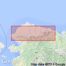
- Alaska Northern region
Summary:
Pg. 4, 6, 25-34, figs. 2-4, pl. 2. Alapah limestone of Lisburne group. Forms upper part of Lisburne group. Comprises nine unnamed members at type locality (ascending): shaly limestone, 85 feet thick; dark limestone, 175 feet; platy limestone, 187 feet; banded limestone, 210 feet; black chert-shale, 38 feet; light-gray limestone, 46 feet; fine-grained limestone, 80 feet; chert-nodule member, 80 feet; and upper limestone, 70 feet. Total thickness 970 feet. Disconformably overlies Wachsmith limestone (new) of Lisburne group. Upper contact is not exposed. Age is probably Late Mississippian based on lithostrotionoid corals and productid brachiopods.
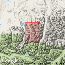
Type section (composite): along ridge top of Sugarloaf Hill, on west slope of Mount Wachsmuth, Lat. 68 deg. 19 min. 40 sec. N., Long. 150 deg. 55 min. 15 sec. W., and at west end of North Ridge, Mount Wachsmuth, Lat. 68 deg. 20 min. N., Long. 150 deg. 55 min. 15 sec. W., central Brooks Range, northern AK.
Type locality: on northern part of Mount Wachsmuth, Shainin Lake area, central Brooks Range.
Named from Alapah Creek, which flows into south end of Shainin Lake.
Source: US geologic names lexicon (USGS Bull. 1200, p. 37); supplemental information from GNU records (USGS DDS-6; Menlo GNULEX).
- Usage in publication:
-
- Alapah Limestone*
- Modifications:
-
- Age modified
- Biostratigraphic dating
- AAPG geologic province:
-
- Alaska Northern region
Summary:
In central and eastern Brooks Range, age is considered Late Mississippian based on revised megafossil zonations. Assemblages (mollusks, brachiopods, corals, and gastropods) range from Meramecian to Chesterian.
Source: Modified from GNU records (USGS DDS-6; Menlo GNULEX).
For more information, please contact Nancy Stamm, Geologic Names Committee Secretary.
Asterisk (*) indicates published by U.S. Geological Survey authors.
"No current usage" (†) implies that a name has been abandoned or has fallen into disuse. Former usage and, if known, replacement name given in parentheses ( ).
Slash (/) indicates name conflicts with nomenclatural guidelines (CSN, 1933; ACSN, 1961, 1970; NACSN, 1983, 2005, 2021). May be explained within brackets ([ ]).