

- Usage in publication:
-
- Akmalik Chert
- Modifications:
-
- Named
- Reference
- Biostratigraphic dating
- Dominant lithology:
-
- Chert
- AAPG geologic province:
-
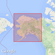
- Alaska Northern region
Summary:
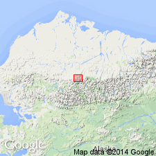
Named as formation in Lisburne Group. Extensively exposed in Kurupa Hills and in Imnaitchiak and Akmalik Creeks area. Type locality designated in canyon of Akmalik Creek, sec.30 T12S R10N, U.P.M. (Killik River quad) about 2 mi (3.2 km) southwest of Kikiktat Mountain, central Brooks Range, northern AK. Reference section is in Kurupa Hills, sec.29 T12S R12W, U.P.M. Contains rocks previously designated "black Lisburne". Consists of bedded black chert with minor amounts of siliceous black mudstone and interbedded black shale. Orange- and red-brown streaks stain surface of chert due to oxidation of included pyrite. Is between 230 and 260 ft thick in Killik River area. Base not well exposed but apparently gradationally overlies Kayak Shale of Endicott Group. Underlies Imnaitchiak Chert (new) of Etivluk Group. Age is considered to be Mississippian to Early Pennsylvanian based on plant fossils, radiolarians and conodonts.
Source: GNU records (USGS DDS-6; Menlo GNULEX).
- Usage in publication:
-
- Akmalik Chert*
- Modifications:
-
- Adopted
- Age modified
- Biostratigraphic dating
- AAPG geologic province:
-
- Alaska Northern region
Summary:
Akmalik Chert of Lisburne Group of Mull and others (1987) is adopted. Consists of bedded, black, spiculite chert with black shale partings with minor amounts of siliceous black mudstone and rare dolomitic limestone beds. Age is Late Mississippian (Meramecian and Chesterian) and Early Pennsylvanian (Morrowan); indicated by radiolarian and conodont assemblages and a plant fossil.
Source: GNU records (USGS DDS-6; Menlo GNULEX).
- Usage in publication:
-
- Akmalik Chert*
- Modifications:
-
- Age modified
- Biostratigraphic dating
- AAPG geologic province:
-
- Alaska Northern region
Summary:
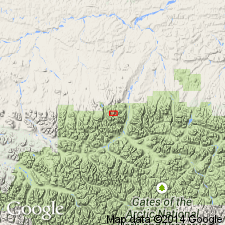
Akmalik Chert of Lisburne Group. Age is restricted to Early to Late Mississippian (middle Osagean to probably late Meramecian; late Tournaisian to Visean) based on conodonts and radiolarians identified from the type section and its counterpart on opposite side of Akmalik Creek (Lat. 68 deg. 23.13 min. N., Long. 154 deg. 19.2 min. W., Killik River quadrangle), and a partial section along an unnamed tributary to Akmalik Creek about 0.2 km to west. Lower part of Akmalik lies within the conodont S. ANCHORALIS-D. LATUS zone of Poole and Sandberg, 1991 (Pacific Sec. SEPM Book 67, p. 107-136), upper part lies within the radiolarian A. CARALLA zone of Won, 1991 (Paleo. Soc. Korea Jour., v. 7, no. 1, p. 13-25).
Source: Publication.
For more information, please contact Nancy Stamm, Geologic Names Committee Secretary.
Asterisk (*) indicates published by U.S. Geological Survey authors.
"No current usage" (†) implies that a name has been abandoned or has fallen into disuse. Former usage and, if known, replacement name given in parentheses ( ).
Slash (/) indicates name conflicts with nomenclatural guidelines (CSN, 1933; ACSN, 1961, 1970; NACSN, 1983, 2005, 2021). May be explained within brackets ([ ]).