The National Geologic Map Database is migrating to a new infrastructure. We apologize for any service disruptions during this process.
|
|---|


- Usage in publication:
-
- Aguila sandstone
- Modifications:
-
- Original reference
- Dominant lithology:
-
- Graywacke
- Conglomerate
- AAPG geologic province:
-
- San Joaquin basin
Summary:
Pg. 7 (fig. 3), 19-20, 41 (App.), pls. 1 (geol. map), 2, 3. See also 1956 [abs.], Dissert. Abs., v. 16, no. 1, p. 101. Aguila sandstone. Massive light-brown medium-grained graywacke with closely spaced concretionary ledges and local thin conglomerate at top. Thickness at type locality 2,035 feet. Rests with apparent conformity upon Johnson Peak formation (new); at most places conformably underlies Serpiente sandstone (new); along south limb of Stoker Canyon syncline, where perhaps as much as 8,000 feet of Upper Cretaceous strata have been removed by erosion, Aguila is unconformably overlain by middle Eocene Avenal sandstone; locally underlies lower Eocene(?) beds. Age is Late Cretaceous.
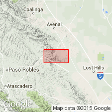
Type locality (see pl. 1 geol. map): measured section H-H', map coords. 1080.7/1429.6 to 1081.1/1430.6, Stoker Canyon syncline, Orchard Peak area, Diablo Range, Tent Hills quadrangle, Kern Co., southern CA.
Named from Aguila Canyon, a canyon on north limb of Stoker Canyon syncline, map coords. 1081.3/1429.8 (see pl. 1 geol. map and App. p. 41), [author's local name for canyon southwest of Three Peaks and northeast of Stoker Canyon, in sec. 31, T. 24 S., R. 17 E., approx. Lat. 35 deg. 47 min. 56 sec. N., Long. 120 deg. 10 min. 42 sec. W., Tent Hills 7.5-min quadrangle, Kings Co., southern CA]. "Aguila" is Spanish word for "eagle."
[GNC remark (Jan. 20, 2019): subsequent geologists consider Marsh's stratigraphic classification to be of local significance. Most apply Anderson and Pack's (1915) stratigraphic terminology and assign these rocks to the Panoche Formation. See also Panoche.]
Source: Publication; US geologic names lexicon (USGS Bull. 1200, p. 29).
For more information, please contact Nancy Stamm, Geologic Names Committee Secretary.
Asterisk (*) indicates published by U.S. Geological Survey authors.
"No current usage" (†) implies that a name has been abandoned or has fallen into disuse. Former usage and, if known, replacement name given in parentheses ( ).
Slash (/) indicates name conflicts with nomenclatural guidelines (CSN, 1933; ACSN, 1961, 1970; NACSN, 1983, 2005, 2021). May be explained within brackets ([ ]).