The National Geologic Map Database is migrating to a new infrastructure. We apologize for any service disruptions during this process.
|
|---|


- Usage in publication:
-
- Aguas Buenas limestone member*
- Modifications:
-
- Revised
- AAPG geologic province:
-
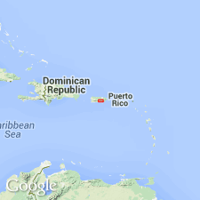
- Caribbean region
Summary:
The Aguas Buenas limestone of Semmes (1919) is correlated with limestone in the Comerio quad. and is revised as the Aguas Buenas limestone member, the basal lenticular limestone of informal formation K near Cidra. Basal strata of formation K adjoin stratigraphically equivalent strata of formation D in the Cayey quad.
Source: GNU records (USGS DDS-6; Reston GNULEX).
- Usage in publication:
-
- Aguas Buenas Limestone Member*
- Modifications:
-
- Revised
- AAPG geologic province:
-
- Caribbean region
Summary:
Aguas Buenas Limestone Member is here redefined, removed from the Fajardo Formation, and assigned to the base of the Torrecilla Breccia. Type locality designated where 30 m of dark-gray finely crystalline, lenticular, reef limestone with rudist and gastropod fauna are exposed. Overlies hydrothermally altered volcanic rock; top is faulted out at type locality, but nearby it is overlain by sandstone and siltstone that grade into volcanic strata of the Torrecilla. Age is Early Cretaceous, probably Albian, based on fossils.
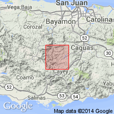
Type locality: quarry (Puerto Rico Meter Grid System 183,640 E.; 41,430 N.) on northwest side of Quebrada la Zapera, 4.1 km north-northeast of Cidra, Comerio quadrangle, north-central Puerto Rico.
Type area: in zone of well-developed karst topography, in Barrio Sumidero, about 3 km due south of Aguas Buenas, Comerio quadrangle, north-central Puerto Rico.
Source: GNU records (USGS DDS-6; Reston GNULEX).

- Usage in publication:
-
- Aguas Buenas Limestone Member*
- Modifications:
-
- Overview
- AAPG geologic province:
-
- Caribbean region
Summary:
The Aguas Buenas Limestone Member of the Torrecilla Breccia occurs in central PR. Member is defined as minor limestone within the formation. The Aguas Buenas is of Early Cretaceous age.
Source: GNU records (USGS DDS-6; Reston GNULEX).
For more information, please contact Nancy Stamm, Geologic Names Committee Secretary.
Asterisk (*) indicates published by U.S. Geological Survey authors.
"No current usage" (†) implies that a name has been abandoned or has fallen into disuse. Former usage and, if known, replacement name given in parentheses ( ).
Slash (/) indicates name conflicts with nomenclatural guidelines (CSN, 1933; ACSN, 1961, 1970; NACSN, 1983, 2005, 2021). May be explained within brackets ([ ]).