The National Geologic Map Database is migrating to a new infrastructure. We apologize for any service disruptions during this process.
|
|---|


- Usage in publication:
-
- Agua Caliente gabbro
- Modifications:
-
- Original reference
- Dominant lithology:
-
- Gabbro
- AAPG geologic province:
-
- Southern Rocky Mountain region
Summary:
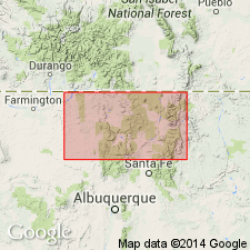
Pg. 11, 25. Agua Caliente gabbro. Gabbroic rocks; not schistose. Suggests that they may be intrusive and of Keweenawan age [Precambrian].
[Type locality not designated.] Notable exposures on one of southern tributaries of Agua Caliente Creek, Picuris area, [in sec. 33, T. 24 N., R. 11 E., and secs. 2, 3, and 12, T. 23 N., R. 11 E., Taos Co.], central northern NM.
Source: US geologic names lexicon (USGS Bull. 1200, p. 26); supplemental information from GNU records (USGS DDS-6; Denver GNULEX).
For more information, please contact Nancy Stamm, Geologic Names Committee Secretary.
Asterisk (*) indicates published by U.S. Geological Survey authors.
"No current usage" (†) implies that a name has been abandoned or has fallen into disuse. Former usage and, if known, replacement name given in parentheses ( ).
Slash (/) indicates name conflicts with nomenclatural guidelines (CSN, 1933; ACSN, 1961, 1970; NACSN, 1983, 2005, 2021). May be explained within brackets ([ ]).