

- Usage in publication:
-
- Agort Chert
- Modifications:
-
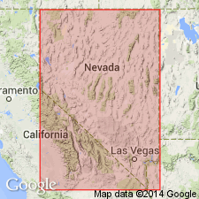
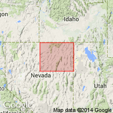
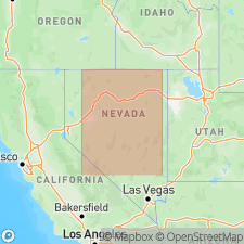
- Areal extent
- Dominant lithology:
-
- Chert
- AAPG geologic province:
-
- Great Basin province
Summary:
Pg. 585 (fig. 3), 587 (fig. 4). Comparison of Lower Paleozoic volcanic and non-volcanic geosynclinal belts in Nevada and Newfoundland. Agort Chert listed in table showing distribution of the sequences with argillites, cherts, and volcanic rocks in Nevada and Idaho. Thickness of chert 800 feet. Occurs above Valder Formation (new) and below Silurian Noh Formation (new). Name credited to Riva (1966, in press). Present in northeastern Nevada. Age is Ordovician.
Type locality and origin of name not stated.
Source: US geologic names lexicon (USGS Bull. 1350, p. 8).
- Usage in publication:
-
- Agort Chert
- Modifications:
-
- Principal reference
- Reference
- Dominant lithology:
-
- Chert
- AAPG geologic province:
-
- Great Basin province
Summary:
Agort Chert. Gray-black, thick-bedded chert with siliceous shaly interbeds. Chert composed of poorly preserved radiolarian tests enclosed in dark carbonaceous matrix streaked with microfibrous quartz. Siliceous shaly interbeds contain poorly preserved graptolites of Middle and Late Ordovician age. Disconformably underlies Noh Formation. Unconformably overlies Valder Formation. Age is considered Ordovician, based on fossils.
Type section: steep slope on northeastern flank of HD Range, Elko Co., northeastern NV (Riva, 1970).
Reference section: on steep slopes between type section of Noh Formation on hill overlooking Bell Canyon, 1 mi northwest of Bell Mine (Riva, 1970).
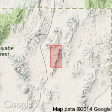
Named from Agort Pass which separates northern end of HD Range from Blanchard Mountain, [Blanchard Mountain 7.5-min quadrangle, Elko Co., northeastern NV] (Riva, 1970).
[HD Range unlabeled on topographic maps; occurs btw. Lat. 41 deg. 37 min. 31 sec. N. and 41 deg. 29 min. 59 sec. N., Long. 114 deg. 37 min. 34 sec. W. and 114 deg. 30 min. 04 sec. W., Knoll Mountain SE, Texas Spring, Blanchard Mountain, Knoll Mountain, and Wine Cup Ranch 7.5-min quadrangles, Elko Co., northeastern NV (USGS GNIS database, accessed June 25, 2014).
Bell Mine located at approx. Lat. 41 deg. 38 min. 30 sec. N., Long. 114 deg. 36 min. 00 sec. N., Texas Spring 7.5-min quadrangle, Elko Co., northeastern NV (USGS historical topographic map collection TopoView, accessed August 9, 2018).]
Source: Modified from GNU records (USGS DDS-6; Menlo GNULEX).
- Usage in publication:
-
- Agort Chert
- Modifications:
-
- Areal extent
- AAPG geologic province:
-
- Great Basin province
Summary:
Pg. 11. Agort Chert of Riva (1970). Succession of gray to black chert beds, as much as 1 foot thick, with gray siliceous-shale interbeds; includes a 25 foot-thick bed of massive light-colored quartzite. Thickness at type locality 700 feet. Lies above Valder Formation and below Tiser Formation. In places, upper part of Agort disconformably underlies basal part of Noh Formation (Silurian); hiatus represents lowermost Silurian. Fossils; carries graptolites of Middle to Late Ordovician age.
Present [locally] in HD Range, Elko County, northeastern Nevada. Not separately mapped; included in allochthonous western assemblage.
Source: Publication.
- Usage in publication:
-
- Agort Chert*
- Modifications:
-
- Areal extent
- AAPG geologic province:
-
- Great Basin province
Summary:
Pg. 3 (column 14), App. p. 23. Agort Chert of Riva (1970). Chert and minor shale. Overlies Ordovician Tiser Limestone and Valder Formation; underlies Silurian Noh Formation; = part of Vinini Formation, based on age and lithology. In places disconformably underlies Mississippian Diamond Peak Formation; erosional hiatus represents Antler orogeny. Age is Late Ordovician.
Present locally in HD Range and nearby Windermere Hills, Elko Co., northeastern NV.
[HD Range unlabeled on topographic maps; occurs btw. Lat. 41 deg. 37 min. 31 sec. N. and 41 deg. 29 min. 59 sec. N., Long. 114 deg. 37 min. 34 sec. W. and 114 deg. 30 min. 04 sec. W., Knoll Mountain SE, Texas Spring, Blanchard Mountain, Knoll Mountain, and Wine Cup Ranch 7.5-min quadrangles, Elko Co., northeastern NV (USGS GNIS database, accessed June 25, 2014).]
Source: Publication; supplemental information from K.B. Ketner, USGS (written commun., 2010).
For more information, please contact Nancy Stamm, Geologic Names Committee Secretary.
Asterisk (*) indicates published by U.S. Geological Survey authors.
"No current usage" (†) implies that a name has been abandoned or has fallen into disuse. Former usage and, if known, replacement name given in parentheses ( ).
Slash (/) indicates name conflicts with nomenclatural guidelines (CSN, 1933; ACSN, 1961, 1970; NACSN, 1983, 2005, 2021). May be explained within brackets ([ ]).