

- Usage in publication:
-
- Agency shale member
- Modifications:
-
- Original reference
- Dominant lithology:
-
- Shale
- AAPG geologic province:
-
- Williston basin
Summary:
Pg. 5. Agency shale member of Pierre shale. Hard fissile very light gray shale defined as basal member of Pierre shale. Exposed thickness about 120 feet. [Age is Late Cretaceous.]
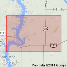
Named from Cheyenne River Agency [in T. 12 N., R. 31 E., Dewey Co., SD], where it is well exposed. Unit extends up Missouri River to within a few mi of mouth of Moreau River, down the Missouri below mouth of Cheyenne River [in Armstrong Co., SD], and some distance up Cheyenne River.
Source: US geologic names lexicon (USGS Bull. 1200, p. 25); supplemental information from GNU records (USGS DDS-6; Denver GNULEX).
- Usage in publication:
-
- Agency shale zone
- Agency shale
- Modifications:
-
- Principal reference
- Revised
- AAPG geologic province:
-
- Williston basin
- Sioux uplift
Summary:
Pg. 8, 18, 19, 22-23. Agency shale zone (also referred to as Agency shale). Rank reduced to zone in Sully member (new) of Pierre formation. At type section consists of light-gray siliceous shale; lower part contains medium-gray concretions greater than 2 feet in diameter, and smaller concretions that weather yellow and reddish-yellow. Base not exposed. Thickness 121 feet. Underlies Oacoma zone (new) of Sully member; Overlies Gregory member of Pierre. In central South Dakota thickness varies from 0 to possibly 125 feet. Appears to be absent south of Crow Creek in Buffalo County, South Dakota (Sioux uplift). Age is Cretaceous. Lists fossils, gives representative sections, and shows outcrop along Missouri River Valley, South Dakota (Williston basin and Sioux uplift).
Type section: measured at the highway bridge across the Missouri River below Whitlocks Crossing and Cheyenne Agency, southeastern Dewey Co., SD (Williston basin).
Source: US geologic names lexicon (USGS Bull. 1200, p. 25); supplemental information from GNU records (USGS DDS-6; Denver GNULEX).
For more information, please contact Nancy Stamm, Geologic Names Committee Secretary.
Asterisk (*) indicates published by U.S. Geological Survey authors.
"No current usage" (†) implies that a name has been abandoned or has fallen into disuse. Former usage and, if known, replacement name given in parentheses ( ).
Slash (/) indicates name conflicts with nomenclatural guidelines (CSN, 1933; ACSN, 1961, 1970; NACSN, 1983, 2005, 2021). May be explained within brackets ([ ]).