

- Usage in publication:
-
- Adams Formation
- Modifications:
-
- Original reference
- Dominant lithology:
-
- Clay
- Silt
- Till
- AAPG geologic province:
-
- Alaska Southeastern region
Summary:
Adams Formation. Formerly called Adams lacustrine-till complex by McKenzie (1969). Composed of clay, and sandy silt with intercalated clayey till. Forms glaciolacustrine deposits, massive to rhythmically bedded. Is 55 m thick. Overlies lower member of Van Horn Formation with sharp contact. Underlies Berg Formation with gradational contact. Age is Holocene (younger than 1,700 +/-100 yr B.P.).
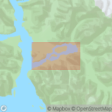
Type section: exposures on southeast shore of Adams Inlet, Lat. 58 deg. 53 min. N., Lat. 135 deg. 47 min. 54 sec. W. [southeast AK]. Top of section has elevation of 199 m and is 1.9 km N. 30 deg. E. of top of Tree Mountain.
Source: GNU records (USGS DDS-6; Menlo GNULEX); US geologic names lexicon (USGS Bull. 1520, p. 5).
For more information, please contact Nancy Stamm, Geologic Names Committee Secretary.
Asterisk (*) indicates published by U.S. Geological Survey authors.
"No current usage" (†) implies that a name has been abandoned or has fallen into disuse. Former usage and, if known, replacement name given in parentheses ( ).
Slash (/) indicates name conflicts with nomenclatural guidelines (CSN, 1933; ACSN, 1961, 1970; NACSN, 1983, 2005, 2021). May be explained within brackets ([ ]).