The National Geologic Map Database is migrating to a new infrastructure. We apologize for any service disruptions during this process.
|
|---|


- Usage in publication:
-
- Adams Argillite*
- Modifications:
-
- Original reference
- Dominant lithology:
-
- Slate
- Quartzite
- Siltstone
- Shale
- Limestone
- AAPG geologic province:
-
- Alaska East-Central region
Summary:
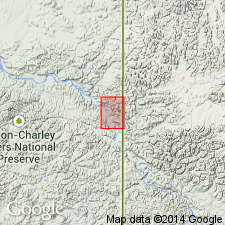
Pg. A7-A9, A17. Adams Argillite. Basal beds are light brown quartzite. Most of quartzite massive, but along Tatonduk River it is thinly bedded and cross laminated and has interbeds of siltstone and grayish-green chloritic shale. Remainder of formation made up of variety of rocks. Argillaceous rocks include gray, green, and red argillite and shale. Isolated outcrop of greenstone occurs about 50 feet above base of Adams Argillite about 1.5 miles northeast of Hillard Peak. Greenstone also occurs in Adams Argillite about 3 miles northeast of mouth of Nation River. Stratigraphic position of this greenstone uncertain, inasmuch as rocks are extensively folded and faulted. Thickness about 600 feet in Hillard Peak area. About 300 feet at east end of Limestone Hogback, but part of formation may be faulted there. Along Tatonduk River seems to be about 400 feet thick. Rests accordantly on Funnel Creek Limestone (new). Underlies Hillard Limestone (new). No complete section found. Age is Early Cambrian, based on fossils (archaeocyathids, trilobites, and specifically OLDHAMIA species).
Type section: at east end of Limestone Hogback, in W/2 sec. 31, T. 2 N., R. 33 E., east-central AK. Named from exposures in vicinity of Adams Peak in east central AK.
Source: US geologic names lexicon (USGS Bull. 1350, p. 6-7); supplemental information from GNU records (USGS DDS-6; Menlo GNULEX).
For more information, please contact Nancy Stamm, Geologic Names Committee Secretary.
Asterisk (*) indicates published by U.S. Geological Survey authors.
"No current usage" (†) implies that a name has been abandoned or has fallen into disuse. Former usage and, if known, replacement name given in parentheses ( ).
Slash (/) indicates name conflicts with nomenclatural guidelines (CSN, 1933; ACSN, 1961, 1970; NACSN, 1983, 2005, 2021). May be explained within brackets ([ ]).