The National Geologic Map Database is migrating to a new infrastructure. We apologize for any service disruptions during this process.
|
|---|


- Usage in publication:
-
- Adam Peak Formation*
- Modifications:
-
- Original reference
- Dominant lithology:
-
- Shale
- Dolomite
- Sandstone
- AAPG geologic province:
-
- Great Basin province
Summary:
Pg. 36-38, pl. 1. Adam Peak formation. Predominantly clastic sequence including shale and siltstone, dolomitic sandstone, chert, and limestone. West of Adam Peak, where section is most complete, formation divisible into three unnamed members: lower, about 850 feet thick, interbedded shale, limestone, and dolomitic sandstone; middle, about 950 feet thick, chert, dolomite, and dolomitic sandstones. True thickness of upper member unknown because of cutting out by overriding Harmony formation. Exposed section about 2,100 feet thick. Overlies Battle formation on crest and west side of Osgood Mountains. Fossils indicate Late Pennsylvanian to Early Permian.
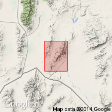
Named from Adam Peak in Osgood Mountains, Osgood Mountains 15-min quadrangle, Humboldt Co., north-central NV. [Type locality not designated, but section described west of Adam Peak.]
Occupies belt about 2.5 mi long on western slope of range west of Adam Peak, from head of East Fork of Eden Creek on north to ridge east of Goughs Canyon on south. Also occurs as fault-bounded blocks along crest of range from Goughs Canyon to Perforate Canyon. Formation is on thrust plate that overrides strata of Etchart limestone at south end of northern belt and along west side of southern blocks.
Source: US geologic names lexicon (USGS Bull. 1350, p. 6); supplemental information from GNU records (USGS DDS-6; Menlo GNULEX).
For more information, please contact Nancy Stamm, Geologic Names Committee Secretary.
Asterisk (*) indicates published by U.S. Geological Survey authors.
"No current usage" (†) implies that a name has been abandoned or has fallen into disuse. Former usage and, if known, replacement name given in parentheses ( ).
Slash (/) indicates name conflicts with nomenclatural guidelines (CSN, 1933; ACSN, 1961, 1970; NACSN, 1983, 2005, 2021). May be explained within brackets ([ ]).