

- Usage in publication:
-
- Ada formation
- Modifications:
-
- Original reference
- Dominant lithology:
-
- Conglomerate
- Limestone
- Sandstone
- Shale
- AAPG geologic province:
-
- Chautauqua platform
- Arkoma basin
Summary:
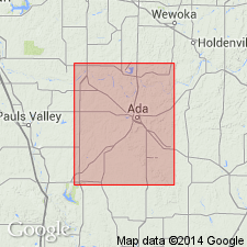
Pg. 128-132, pls. 3, 27, and map; name was also used by Morgan (but not defined) in Oklahoma Geol. Survey Circ., no. 12, pl. and p. 15, 1923. Ada formation. Present in Pontotoc and Seminole Counties, Oklahoma. Outcrop extends from northern edge of Stonewall quadrangle, north of Vamoosa, southwestward to a point about 3 miles southeast of Roff. Limestone conglomerates and coarse sandstones are very prominent along greater portion of outcrop. The shales are mostly light colored. Near base is a thin black limestone that is very persistent in vicinity of Ada. Clastic material becomes less toward north and in vicinity of Vamoosa is very scarce. With decrease in amount of clastic material the formation becomes thinner. Average thickness is 100+/- feet. At north edge of quadrangle it is only 60+/- feet thick. Conglomerates and sandstones characteristically saturated with asphalt. Asphaltic strata become less numerous north of Canadian River. Source of asphalt unclear; possibly heavy oil from exposed asphaltic sands of Simpson formation was brought out and deposited. Fossils scarce. North of Canadian River it appears to rest conformably on Vamoosa formation (new), but to south it overlaps Vamoosa and several older formations. Age is Pennsylvanian. Report includes geologic map.
[Named from development within and to west of town of Ada, Pontotoc Co., central southern OK.]
Source: US geologic names lexicon (USGS Bull. 896, p. 12); GNC OK Corr. Chart, sheet 2, Jan. 1931; supplemental information from GNU records (USGS DDS-6; Denver GNULEX).
For more information, please contact Nancy Stamm, Geologic Names Committee Secretary.
Asterisk (*) indicates published by U.S. Geological Survey authors.
"No current usage" (†) implies that a name has been abandoned or has fallen into disuse. Former usage and, if known, replacement name given in parentheses ( ).
Slash (/) indicates name conflicts with nomenclatural guidelines (CSN, 1933; ACSN, 1961, 1970; NACSN, 1983, 2005, 2021). May be explained within brackets ([ ]).