The National Geologic Map Database is migrating to a new infrastructure. We apologize for any service disruptions during this process.
|
|---|


- Usage in publication:
-
- Accomack Member*
- Modifications:
-
- Original reference
- Dominant lithology:
-
- Sand
- Gravel
- Silt
- Clay
- Peat
- AAPG geologic province:
-
- Atlantic Coast basin
Summary:
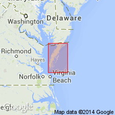
The Accomack beds of Mixon and others (1982), the dominantly transgressive sequence of sand, gravel, silt, clay, and peat that underlies the upland in the area north and west of the Ames Ridge shoreline in Accomack Co., VA, are here named the Accomack Member of the Omar Formation. It is well developed from Wallops Station, VA, to Shelltown, MD. Informal facies A through G represent marginal marine depositional environments. Unconformably overlies the Tunnels Mill Member of the Yorktown Formation; disconformably underlies the Occohannock Member of the Nassawadox Formation. Thickness at type section is 58 ft (18 m). Age is middle or late Pleistocene, based on paleomagnetic data, U/Th ages, and fossils.
Source: GNU records (USGS DDS-6; Reston GNULEX).

- Usage in publication:
-
- Accomack Member
- Modifications:
-
- Overview
- AAPG geologic province:
-
- Atlantic Coast basin
Summary:
Nomenclature on State map follows Mixon (1985). Accomack Member of Omar Formation is present east of Chesapeake Bay. Described in Accomack Co. as light- to dark-gray, light-yellowish-gray, brownish-gray, and yellowish-orange sand, gravel, silt, clay, and peat of southwest-trending central upland (altitude 38 to 50 ft). Upper part of unit is bounded on east and west by ocean- and bay-facing scarps; lower part is present in subsurface of adjacent lowland areas where it is overlain unconformably by upper Pleistocene and Holocene deposits. In northern part of county, unit is a barrier-backbarrier sequence of clean, cross-bedded, gravelly sand (above) and peat, clayey silt, and muddy sand (below). Mollusks include CRASSOSTREA, MERCENARIA, and NOETIA. In southern part of county, fine to coarse, trough cross-bedded sands of barrier-spit origin overlie fine- to very fine grained, muddy, nearshore-shelf sand containing SPISULA, ENSIS, ANOMIA, and MULINIA. At base of unit, pebbly to bouldery, medium- to very coarse grained sand and thick, compact clay-silts constitute the fluvial-estuarine fill of a paleochannel of the Susquehanna River system. Accomack Member and underlying channel fill are as much as 200 ft, or more, in thickness. Age is middle Pleistocene.
Source: GNU records (USGS DDS-6; Reston GNULEX).
For more information, please contact Nancy Stamm, Geologic Names Committee Secretary.
Asterisk (*) indicates published by U.S. Geological Survey authors.
"No current usage" (†) implies that a name has been abandoned or has fallen into disuse. Former usage and, if known, replacement name given in parentheses ( ).
Slash (/) indicates name conflicts with nomenclatural guidelines (CSN, 1933; ACSN, 1961, 1970; NACSN, 1983, 2005, 2021). May be explained within brackets ([ ]).