The National Geologic Map Database is migrating to a new infrastructure. We apologize for any service disruptions during this process.
|
|---|


- Usage in publication:
-
- Abbyville gabbro
- Modifications:
-
- Original reference
- Dominant lithology:
-
- Gabbro
- AAPG geologic province:
-
- Piedmont-Blue Ridge province
Summary:
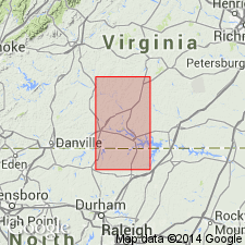
Pg. 37-38, map. Abbyville gabbro. Much altered intrusive hornblende gabbro of dirty greenish gray color; coarse-grained.
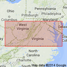
Occurs in vicinity of Abbyville, Mecklenburg Co., central southern VA.
Source: US geologic names lexicon (USGS Bull. 896, p. 8).
- Usage in publication:
-
- Abbyville gabbro
- Modifications:
-
- Age modified
- AAPG geologic province:
-
- Piedmont-Blue Ridge province
Jonas, A.I., 1928, Geological map of Virginia; preliminary edition: Virginia Geological Survey
Summary:
Abbyville gabbro. Mapped the hornblende gabbro around Abbyville, Virginia, as of pre-Cambrian age and as intrusive into Glenarm series (Algonkian?).
Source: US geologic names lexicon (USGS Bull. 896, p. 8).
For more information, please contact Nancy Stamm, Geologic Names Committee Secretary.
Asterisk (*) indicates published by U.S. Geological Survey authors.
"No current usage" (†) implies that a name has been abandoned or has fallen into disuse. Former usage and, if known, replacement name given in parentheses ( ).
Slash (/) indicates name conflicts with nomenclatural guidelines (CSN, 1933; ACSN, 1961, 1970; NACSN, 1983, 2005, 2021). May be explained within brackets ([ ]).