The National Geologic Map Database is migrating to a new infrastructure. We apologize for any service disruptions during this process.
|
|---|


- Usage in publication:
-
- Fishtrap dolomite
- Modifications:
-
- Named
- Dominant lithology:
-
- Dolomite
- Limestone
- AAPG geologic province:
-
- Montana folded belt
Summary:
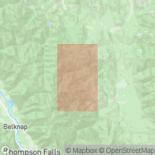
Named as an informal unit. Fishtrap is part of newly recognized section of Paleozoic rocks in drainage basin of Fishtrap Creek (for which unit was probably named), near Thompson Falls, Sanders Co, MT, Montana folded belt province. Available geologic maps have indicated only Precambrian Beltian rocks and Quaternary alluvial material in area. Paleozoic rocks crop out in an area 1-3 mi wide by a minimum of 12 mi (and possibly up to 40 mi) long. Described as gray dolomitic limestone; also referred to as a dolomite. Thickness is about 2500 ft. Based on limited mapping, unit does not appear to have direct correlative in MT Paleozoic section. Trilobites and brachiopods collected near base of 50-ft shale unit, here assigned to Wolsey Shale, in SE1/4 NE1/4 sec 26, T24N, R28W, were identified by A. R. Palmer (USGS) as Middle Cambrian. Conformably overlies Wolsey Shale; conformably underlies undifferentiated sequence of sandstones, quartzite, and micaceous shales.
Source: GNU records (USGS DDS-6; Denver GNULEX).
- Usage in publication:
-
- Fishtrap Formation
- Modifications:
-
- Overview
- AAPG geologic province:
-
- Montana folded belt
Summary:
Divides Fishtrap into six lithofacies referred to as, in ascending order: 1) mottled lime and dolomudstone (250 m thick); 2) oolitic, peloidal dolograinstone (58 m thick); 3) cryptalgal dolobindstone/mudstone (90 m thick); 4) shale/ siltstone (90 m thick); 5) crystalline cryptalgal dolobindstone (374 m thick); and 6) crystalline sandy dolostone and cryptalgal dolobindstone (33 m thick). Lithology described and depositional environment discussed for each lithofacies. Overlies Gordon Shale with gradational contact; underlies unnamed Ordovician sequence of quartz arenite and dolostone. Study area is in Libby trough between Libby, Lincoln Co, MT, and Thompson Falls, Sanders Co, MT, Montana folded belt province. Generalized stratigraphic section. Generalized correlation chart (fig. 5) shows Fishtrap correlates in part with Lakeview Formation in ID; lithofacies 1-5 correlate with Damnation, Dearborn, Pagoda, Steamboat, Switchback, and Devils Glen Formations in Lewis and Clark Range, MT; and Fishtrap correlates with Meagher, Park, Pilgrim, and Red Lion Formations in southwest MT. Fishtrap represents three upward-shallowing Grand Cycles which formed during contraction-expansion of an extensive peritidal algal-shoal complex. Based on paleontological data from underlying Gordon and overlying unnamed rocks, Fishtrap assigned Middle to latest Cambrian age.
Source: GNU records (USGS DDS-6; Denver GNULEX).
For more information, please contact Nancy Stamm, Geologic Names Committee Secretary.
Asterisk (*) indicates published by U.S. Geological Survey authors.
"No current usage" (†) implies that a name has been abandoned or has fallen into disuse. Former usage and, if known, replacement name given in parentheses ( ).
Slash (/) indicates name conflicts with nomenclatural guidelines (CSN, 1933; ACSN, 1961, 1970; NACSN, 1983, 2005, 2021). May be explained within brackets ([ ]).