

- Usage in publication:
-
- Bopesta formation*
- Modifications:
-
- Named
- Biostratigraphic dating
- Dominant lithology:
-
- Sandstone
- Ash
- Shale
- AAPG geologic province:
-
- Sierra Nevada province
Summary:
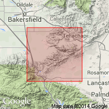
Named from Bopesta Ridge, southwest of Cache Peak, Kern Co, CA. [Name Bopesta formation first used by Buwalda (1934) in abstract]. Type section designated from near confluence of Cache Creek and its East Fork (which heads on south side of Cache Peak) in NW/4 sec.1 T32S R34E to north side of Cache Peak, sec.20 T31S R35E. Widely exposed in badlands areas east of upper Cache Creek 6 to 7 mi northeast of Monolith, Kern Co. Consists of tan and white, fine and coarse quartzose sandstones containing some ash and volcanic debris, few conglomeratic beds, and some gray sandy shale beds. Is probably not less than 3500 ft thick. Probably conformably overlies Kinnick formation (new) but contrasts strongly as mappable unit. Unconformably(?) underlies basic lavas. Age is late Miocene based on Cache Peak vertebrate fauna in lower and middle part of unit.
Source: GNU records (USGS DDS-6; Menlo GNULEX).
- Usage in publication:
-
- Bopesta Formation*
- Modifications:
-
- Revised
- AAPG geologic province:
-
- Sierra Nevada province
Summary:
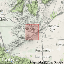
Bopesta Formation is extended downward at expense of underlying Kinnick Formation. Type section herein revised as follows: from contact with underlying pyroclastic rocks of Kinnick Formation (restricted) in NE/4 sec.11 T32S R34E northeastward to base of overlying andesite in NW/4 sec.31 T31S R35E, Kern Co, CA.
Source: GNU records (USGS DDS-6; Menlo GNULEX).
- Usage in publication:
-
- Bopesta Formation
- Modifications:
-
- Overview
- Biostratigraphic dating
- AAPG geologic province:
-
- Sierra Nevada province
Summary:
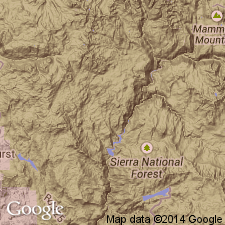
Neostratotype [principal reference] section designated along north-northwest trending transect from NW/4 sec.4 T32S R35E to SE/4 sec.32 T31S R35E in canyon draining south in Pine Tree Canyon [Kern Co, CA] because all four informal units of Bopesta Formation are well exposed here. Base of lowermost unit is defined as top of stratigraphically highest basalt of Kinnick Formation. Lowermost unit is chiefly lacustrine and marginal lacustrine sedimentary deposits. Andesitic agglomerate and breccia are intercalated with and overlie lowermost unit. Overlying middle and uppermost units are composed primarily of fluviatile deposits. Greatest exposed thickness is 2100 ft. Conformably overlies Kinnick Formation. Unconformably underlies informal Cache Peak formation of Michael (1960, unpub. Masters thesis). Three successive equid range zones are recognized in Bopesta. List and locations on map of fossils included. Deposition occurred between 17 and 14 Ma [based on correlation].
Source: GNU records (USGS DDS-6; Menlo GNULEX).
For more information, please contact Nancy Stamm, Geologic Names Committee Secretary.
Asterisk (*) indicates published by U.S. Geological Survey authors.
"No current usage" (†) implies that a name has been abandoned or has fallen into disuse. Former usage and, if known, replacement name given in parentheses ( ).
Slash (/) indicates name conflicts with nomenclatural guidelines (CSN, 1933; ACSN, 1961, 1970; NACSN, 1983, 2005, 2021). May be explained within brackets ([ ]).