

- Usage in publication:
-
- Morales member*
- Modifications:
-
- Named
- Dominant lithology:
-
- Clay
- Sand
- Gravel
- Shale
- AAPG geologic province:
-
- Transverse Ranges province
Summary:
Named for its development in Morales Canyon, Cuyama Valley, CA, as upper member of Santa Margarita formation. Consists of about 2000 ft of clay, white sand, and gravel with in its lower part, 300 to 400 ft of light-gray, poorly bedded soft clay shale, containing a few thin beds of white limestone (which on weathering break up into small irregular fragments). Unconformably overlies Whiterock Bluff shale member (new) of Santa Margarita formation; also unconformably overlies pre-Monterey rocks. Unconformably underlies Cuyama formation (new). Map legend shows age as Miocene.
Source: GNU records (USGS DDS-6; Menlo GNULEX).
- Usage in publication:
-
- Morales formation*
- Modifications:
-
- Principal reference
- Revised
- Age modified
- AAPG geologic province:
-
- Coastal basins
- Santa Maria basin
- Ventura basin
Summary:
Pg. 2974 (fig. 1), 2978 (fig. 3), 2990 (fig. 8), 2996-2998. Morales formation. Rank raised to formation. [Morales member of Santa Margarita formation of English (1916) is raised in rank to Morales formation because Morales and Santa Margarita are so unlike and are separated by an unconformity of regional extent.] At designated type locality, about 2,750 feet thick and consists of basal conglomerate 0 to 50 feet thick; alternating claystone, sandstone, and gravel about 1,300 feet; and sandstone and gravel about 1,400 feet.
South of Cuyama River, lower part of Morales consists of about 1,300 feet of gray gypsiferous claystones of lacustrine origin (mapped as Santa Margarita by English, 1916, and as Pleistocene lake beds by Eaton and others, 1941, AAPG Bull., v. 25, no. 2) which are conformably overlain by 1,500 feet of sand and gravel (here mapped as Cuyama formation by English, 1916, and included in Pleistocene fans by Eaton and others, 1941). Along south margin of Cuyama Valley, between Castro and Santa Barbara Canyons, as much as 1,000 feet of Morales sandstone, gravels, and claystone (mapped as Cuyama by English, 1916) are exposed and lie directly on Santa Margarita sandstone. In subsurface of Cuyama Valley, the Morales is more than 5,000 feet thick. In Cuyama Badlands, the Morales (here mapped as Santa Margarita by English, 1916) is approximately 4,200 feet thick and consists of an upper unit (2,200 feet) of coarse gray incoherent conglomerate made up of debris of granitic, gneissic, quartzitic rocks, schist, basalt, sandstone, and white shale; and a lower unit (2,000 feet) of pebble-conglomerate-sandstone with similar debris, and interbeds of gray sandy siltstone resting conformably on Quatal formation.
Regionally, Morales is unconformably overlain by Pleistocene alluvial fans; in Cuyama Valley, unconformably overlain by Pleistocene fanglomerates; in northern Cuyama Badlands and Carrizo Plain, overlain by Pleistocene Paso Robles formation. Age is probably Pliocene, based on stratigraphic relations.
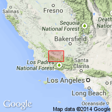
Type locality: from Whiterock Bluff eastward through sec. 25, T. 11 N., R. 28 W., and sec. 30, T. 11 N., R. 27 W., Caliente Mountain 15-min quadrangle, San Luis Obispo Co., CA. Named from Morales Canyon.
Source: US geologic names lexicon (USGS Bull. 1200, p. 2585-2586); GNU records (USGS DDS-6; Menlo GNULEX).
- Usage in publication:
-
- Morales Formation*
- Modifications:
-
- Revised
- Areal extent
- Age modified
- AAPG geologic province:
-
- California Coast Ranges province
- Transverse Ranges province
Summary:
Unit revised as the Morales Formation consisting of: (1) the Morales Formation of Hill and others (1958) and (2) the herein-abandoned Panorama Hills Formation of Dibblee (1962). Unit age is regarded as "probably late" Pliocene based on vertebrate megafossil (EQUUS sp. tooth) from middle of 5000-ft-thick section of unit.
Source: GNU records (USGS DDS-6; Menlo GNULEX).
For more information, please contact Nancy Stamm, Geologic Names Committee Secretary.
Asterisk (*) indicates published by U.S. Geological Survey authors.
"No current usage" (†) implies that a name has been abandoned or has fallen into disuse. Former usage and, if known, replacement name given in parentheses ( ).
Slash (/) indicates name conflicts with nomenclatural guidelines (CSN, 1933; ACSN, 1961, 1970; NACSN, 1983, 2005, 2021). May be explained within brackets ([ ]).