
North American Data Model Steering Committee
Notes of meeting October 27-28, 1999, Denver, Colorado
Attending:
- Brian Berdusco (OGS)
- Tom Berg (OH)
- Boyan Brodaric (GSC)
- Bruce Johnson (USGS)
- Rob Krumm (IL)
- Jonathan Matti (USGS)
- Scott McColloch (WV)
- Peter Schweitzer (USGS)
- Dave Soller (USGS)
- Loudon Stanford (ID)
Visitors:
- Eric Boisvert (GSC)
- Murray Journeay (GSC)
- Andy Rorick (U.S. Forest Service)
Notes:
- Discussion and approval of charters:
Steering Committee (SC) charter -- the 10/14/99 version was approved, with an amendment that provides for a committee coordinator (see item 5, below). Dave will make revisions and circulate to SC for concurrence. If, after one week from date of circulation, no objections are noted, the charter will be considered approved and will be posted to the SC web site.
Requirements Analysis Technical Team (RATT) charter -- approved, with minor changes. Dave will make revisions and circulate to SC for concurrence. If, after one week from date of circulation, no objections are noted, the charter will be considered approved and will be posted to the SC web site.
Data Model Design Technical Team (DMDTT) charter -- the 6/14/99 version was approved. The charter now will be posted to the SC web site.
Science Language Technical Team (SLTT) charter -- the 10/5/99 version was approved, with minor changes regarding the delivery of reports to the SC. Jon will make revisions and circulate to SC for concurrence. If, after one week from date of circulation, no objections are noted, the charter will be considered approved and will be posted to the SC web site.
Tool Development Technical Team (TDTT) charter -- the 10/14/99 version was approved, pending minor revisions. Peter will make revisions and circulate to SC for concurrence. If, after one week from date of circulation, no objections are noted, the charter will be considered approved and will be posted to the SC web site. The SC considered including in the charter the responsibility for user support and training, but will defer on this issue until software products become available. At that time, the SC may ask the TDTT to address these issues, or may form a new team.
Documentation Technical Team (DTT) charter -- the 10/5/99 version (v.2.0) was discussed. Rather than address long-term needs for documenting the conceptual data model and software tools, it was decided to focus on topics that can be completed within one year. The first task will likely be to develop a general-interest pamphlet that explains the concepts of the data model and what the SC plans to accomplish; detailed documentation of the data model (v.4.3) will be written at some later time. The first meeting of the DTT will address the possible tasks and develop a work plan, for SC concurrence. Loudon will make revisions to the charter and circulate to SC for concurrence. If, after one week from date of circulation, no objections are noted, the charter will be considered approved and will be posted to the SC web site.
Data Interchange Technical Team (DITT) charter -- the 9/29/99 version (v.1.1) was approved. The charter now will be posted to the SC web site.
Eric Boisvert and Boyan Brodaric led discussion of GSC/USGS supported software tool "Geomatter II". This tool, introduced at the Digital Mapping Techniques '99 (DMT'99) workshop and at the 1999 GSA annual meeting, will become available within the next few weeks. At that time, the SC will evaluate the tool and offer suggested revisions. Shortly thereafter, an announcement and short description will be posted to the data model Web conference site, (), with a link to the DMT'99 paper (at ), and the public will be invited to contact SC members for access to the tool. [Direct, unrestricted public access to the tool cannot yet be given, as it is based on third-party code.]
Andy Rorick (rorick_andy/[email protected]) presented the U.S. Forest Service (USFS) program to develop earth-science standardsfor their mapping and database activities. This program, known as the Natural Resource Information System (NRIS) contains a terrestrial module (Terra) that includes geologic and related topics. Andy is responsible for development and maintenance of geology and geomorphology standards for NRIS. Following a period of development within the USFS, this system will be made available to the public. Andy has contacted the SC in order to evaluate, and attempt to incorporate, elements of the SC's data model design into Terra. Andy has asked to be included on the SLTT, and the SC concurs. The NRIS is in some ways similar to the National Park Service's (NPS) National Resources Inventory and Monitoring program (see <http://pubs.usgs.gov/openfile/of98-487/gregson.html> and <http://pubs.usgs.gov/openfile/of99-386/gregson.html> ); the SC will contact the NPS, to ensure they are aware of SC activities.
Selection of a SC Coordinator:
At the request of some SC members, it was decided to appoint a SC coordinator. Responsibilities will include: 1) leading the SC meetings; 2) working with SC members to develop meeting agendas; 3) compiling the meeting minutes; and 4) being the official point of contact for the SC. Dave was selected to serve as Coordinator. The SC accepted for inclusion in the SC charter Jon's draft defining this position. Dave will circulate the revised SC charter.
Funding for the Technical Teams:
When members are selected for Technical Teams, some arrangement must be made to cover each member's salary and travel expenses. Before discussing the staffing of Technical Teams, the SC reviewed the available funding sources. Given the lack of sufficient funds to reimburse agencies for salary costs for technical team members, the discussion focused on funds needed to support travel to meetings, training, and potential software development costs. It must be assumed that each participating agency will support salary costs for its technical team members. In the GSC, efforts to obtain funding to support the data model activities will continue. In the USGS, the new data model project has requested operating expenses sufficient to pay for travel for numerous technical team members. State geological surveys will pay for most travel expenses for their technical team members; these funds are supplemented by STATEMAP administrative funds charged by the National Cooperative Geologic Mapping Program, which is operated cooperatively by the AASG and USGS. Several ideas arose that might help generate the needed funds: 1) the USGS and GSC will develop an "annex" (similar to a project) under the joint Memorandum of Agreement, to formally recognize the data model effort (Dave will write a draft, send it to Boyan for comment, and the revised annex will be circulated to the SC for comment before it is forwarded to management); 2) the NSF digital library initiative might be a source of funds (Murray will investigate); and 3) USGS Bureau-level funding might be sought, as this effort helps promote Bureau goals for data integration.
Visitor attendance:
The SC decided that, with prior approval, visitors are welcome to attend its meetings. A request to attend shall be forwarded by a SC member to the SC for comment; if there are no objections, given the topics to be discussed, the visitor is welcome to attend the next meeting.
Membership:
Membership will be limited to a Nation's principal geoscience agency(s). The Mexican geological survey has been invited to join the SC; they are interested, and are in the process of identifying the appropriate person. Regarding appointment of the second GSC member, the SC agreed with the GSC request to have a small number of persons (less than 5) share the seat. Following the SC decision to appoint a coordinator, selection of the second Canadian Province member can now proceed.
Preliminary report of the RATT:
Tom and Brian coordinated surveys of (respectively, state geological surveys and Canadian geoscience agencies, societies, and private companies). The SC was not, however, able to conduct a survey within the USGS prior to this meeting. In their surveys, two questions were asked, those being developed at the May SC meeting (i.e., "How do you and your clients want to use digital geologic maps" and "What hardware and software do you employ to build and use digital geologic maps"). Tom's survey asked a third question -- "Who are the users of digital geologic maps and related databases that your agency produces." The SC thanks Lisa Smith (Illinois GS) and Sonia Talwar and Marianne Quat (both GSC) for their invaluable help in conducting the survey and summarizing the results. The survey of states yielded 24 respondents; the Canadian survey yielded 33 respondents. The SC found these reports to support the SC's general perceptions of the user needs and capabilities. It was decided that each technical team chair would review the report for new insights and ideas, prior to the team's first meeting.
New opinion survey:
The first RATT survey provided the SC with valuable information, of a general nature. After extensive discussion, the SC decided not to use this survey format in any further information-gathering efforts, but rather to develop a new survey. The new survey will be designed to provide more detailed guidance and ideas to the technical teams, as they develop their work plans. The SC intends to direct this new survey, or opinion poll, to a broader audience including publications such as GSA Today, AAPG Explorer, and Geotimes. While developing this survey for publication in these venues, it will be released within the USGS both to gather new information and to provide guidance on format changes, prior to publication.
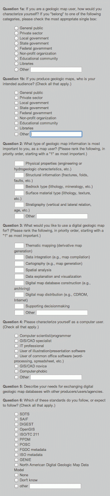
The survey will be prefaced by a brief introduction that explains the purpose of the survey, the history of the data model development effort, pertinent URLs, etc. The survey questions will be:
The survey also will ask for respondent's name, affiliation, and e-mail, and will stipulate a deadline for responding.
The SC will review the survey's questions and general format, and respond with comments within two weeks. Then, Brian, Tom, Dave, and Jon will discuss how to proceed.
Populating the technical teams:
For each TT, the SC described the tasks to be undertaken in the first year, estimated the optimal team size, described actions taken to identify nominees, and discussed each nominee.
Data Interchange TT: The task will be to develop a universal transfer standard. Bruce, the interim chair, prefers a team with a maximum of 3 to 4 members. Bruce will contact the nominees. If they are not interested, Bruce will identify other candidates and notify the SC. The SC can provide comment, but the final choice will be made by the Chair.
Tool Development TT: The tasks will include: examining architectural principles, identifying the types of tools needed, evaluating user needs, and perhaps some tool-building. The first meeting will be held after the USGS budget is approved by Congress. Peter is the interim chair. Peter will contact the nominees. If they are not interested, Peter will identify other candidates as needed and notify the SC. The SC can provide comment, but the final choice will be made by the Chair.
Requirements Analysis TT: The task described in #9 above will be addressed as soon as possible. Team members are: Brian, Tom, Dave, Jon, Sonya Talwar, and Lisa Smith.
Data Model Design TT: The general task will be to field comments and make revisions to the data model as needed. Specific tasks will be determined at the first meeting. Boyan is the interim chair. Boyan will contact the nominees. If they are not interested, Boyan will identify other candidates as needed and notify the SC. The SC can provide comment, but the final choice will be made by the Chair.
Documentation TT: As noted in #1 above, tasks will be determined at the first meeting. Loudon is the interim chair. Nominees will be contacted; if they are not interested, Loudon will identify other candidates as needed and notify the SC. The SC can provide comment, but the final choice will be made by the Chair.
Science Language TT: Jon, the interim chair, outlined the challenges inherent in forming such a team. Care must be taken to ensure an even mix of expertise, disciplines, agencies, and regions. Jon began the discussion by describing the backgrounds and extertise of each candidate nominated by the USGS Regional Geologists, in response to the memo he recently sent to them. USGS members of the SC then volunteered additional names. Additional candidates, from the states, Canada, and academia were then offered. More candidates from the Provinces and states also will be sought. At this point in the discussion, roughly 50 names had been offered, with many more expected within the next two to three months. It also was suggested that additional candidates be sought from academia, the map user community, and other agencies. To evaluate whether we have the appropriate mix of scientific disciplines, it was suggested that we consult the discipline list in the AGI GEOREF catalog.
The SC then discussed how to cull the list of candidates down to a manageable size, and whether there should be a core group (the TT) that builds the strawman science classifications and a larger, consultant group that provides comment. It was proposed that all candidates be invited to a workshop, perhaps in late winter, to be introduced to the overall task. As the discussion concluded, a decision was not made on how to proceed -- Jon will consider the advice given, decide how to proceed with selection of team members, and notify the SC.
Miscellaneous:
Discussion of user support, training, and software maintenance was deferred until the appropriate technical teams provide products. It was noted that the SC must remain aware of plans and progress in other standards-development efforts, especially OGC, POSC, and PPDM.
Name change:
It was decided that the SC's reference to its goal, advancement of the "Data Model", was too vague. The SC decided to name this effort the "proposed North American digital geologic map data model", until such time as the GSC/USGS "annex" is approved; then, we will no longer refer to it as "proposed". The acronym for this activity will be "NADM", and for the steering committee, "NADMSC". Quite a mouthfull.
Next meeting:
The next meeting will be in conjunction with the Digital Mapping Techniques '00 workshop, in Lexington, KY. Tentatively, the workshop is scheduled for May 17-20, and, as soon as possible, the coordinator will propose a meeting date for the NADMSC. At the meeting, reports from technical teams will be given. Teams are encouraged to also present their tasks and progress at the DMT'00 workshop. Finally, Boyan offered to host a NAMDSC meeting at Penn State, possibly including a workshop on spatial representation.