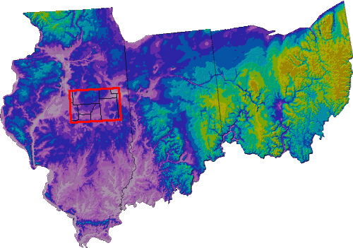
| Valleys in the bedrock surface contain groundwater resources: Throughout this area, glaciers scoured the landscape and, where they flowed over relatively weaker bedrock, deep valleys were carved. Where river valleys existed before the glaciers, they were modified and deepened. During the glaciations, these valleys were filled with glacial and river sediment. Within these sediments (mostly glacial till) there are thick sand and gravel deposits that contain valuable sources of groundwater for the region. In the study area (shown in red), the large preglacial valley is known as the Mahomet Bedrock Valley. The groundwater aquifer in this valley is more than 100 feet thick, and is the principal water supply for cities, industry, and homes.
|