[This paper was presented in Oct., 1998, and was published in Derksen, C.R.M., and Manson, C.J., editors, 1999, Accreting the continent's collections: Geoscience Information Society Proceedings, v. 29, p.47-55. Reproduced by permission.]
ABSTRACT
The principal stated purpose of the National Geologic Mapping Act of 1992 and 1997 is to build a national archive of geologic and related maps, to be known as the National Geologic Map Database. In 1995, planning began, and in 1996 a project was formed to develop the Database. Information about this project can be found at "http://ncgmp.usgs.gov/ngmdbproject". The Database is designed as a distributed system, through cooperation between the USGS and the Association of American State Geologists. The first phase of the project is to develop a comprehensive catalog of all published paper and digital geoscience maps of areas within the United States. As of Spring, 1998, about 26% of all maps were cataloged and available for search at the Database Web site ("http://ngmdb.usgs.gov"). To support the use of these maps, we have prepared at that URL a Lexicon of Geologic Names. During the remainder of 1998, work will include: development of databases and web pages for paleontology and geologic mapping in progress; enlargement of the map catalog with state geological survey entries; and continued work on the development of various standards and data models to support work on the project's next phase -- on-line access to standard geologic map products.
Both the USGS Strategic Plan and the Geologic Division Strategic Science Team Report support development of a viable National Geologic Map Database. This is one goal among many important management objectives, and limits on staffing and funding will necessitate difficult decisions. Recognition in these two reports of the value of the Database, and its prioritization through the Geologic Mapping Act as an important Federal and State government responsibility favor evolution of the project into a well-supported information resource for the community.
INTRODUCTION
The National Geologic Map Database is the product of two emerging societal trends-public access to the Internet, and the demand for scientific information relevant to societal issues. Historically, the availability of geologic maps and data could be known only by contacting or visiting an agency or institution to order products or conduct a library search. This process was cumbersome and somewhat inefficient. With increased use of the Internet via commonly-available web browsers, the public increasingly finds this approach unacceptable. In response, many agencies and libraries have begun to offer some Internet access to their information.
Geologic map information supplied by the earth-science agencies may or may not be used by the public, depending on its real or perceived utility to financial, environmental, land-use, and other societal issues. In 1990, the Office of Management and Budget questioned the value of geologic maps, and challenged the USGS's geologic mapping program to demonstrate a measureable utility of geologic maps, such that the economic efficiency of certain land-use decisions would be increased if geologic map information were used. The resulting study (Bernknopf and others, 1993) demonstrated this value, and it was clear to all concerned that geologic maps no longer could be justified solely on the basis of anecdotal evidence. Further, it was obvious that to maintain relevance to society and to the increasing number of map users employing geographic information systems (GIS), geologic maps must be produced in digital format.
In 1992, partly in response to these trends, Congress enacted the National Geologic Mapping Act. While asserting that geologic maps are useful and necessary to society, the Act called for increased production of high-quality maps by the state geological surveys and the USGS, through a newly-established partnership, the National Cooperative Geologic Mapping Program. This mapping program was justified in part by development of a National Geologic Map Database (NGMDB), as noted in the Act: "The purpose of this Act is to expedite the production of a geologic-map data base for the Nation, to be located within the United States Geological Survey, which can be applied to land-use management, assessment, and utilization, conservation of natural resources, groundwater management, and environmental protection."
DATABASE DESIGN AND PROGRESS
The Geologic Mapping Act stipulates that the NGMDB will be a national archive of geoscience maps, intended to provide the information needed to address various societal issues. The Act also mandates development of various standards to promote more efficient use of the map information. In mid-1995, the general stipulations in the Act were addressed by the USGS and the Association of American State Geologists (AASG), and the plan for building the Database was summarized by Soller and Berg (1995).
In considering the Act's general requirements for the NGMDB, we were faced with two different design philosophies: 1) a more traditional, searchable catalog of available maps; and 2) a more research-oriented project intended to provide users with access to digital maps via an interactive, map-based display. In discussions with potential users in the public and private sectors, it became clear that the primary goal must be to provide a searchable listing of available maps, and guidance on how to obtain those maps. Because most maps are not in digital form and because many organizations produce and distribute geologic maps, this was the only approach feasible within a reasonable period of time. In time, we may adopt some aspects of the second design philosophy; this will be facilitated by development of standards, an increase in the number of digital maps, research on interoperability among different software and data models, increases in bandwidth, and improvements in client-server software for data display and manipulation.
The NGMDB design consists of several phases. The first and most fundamental phase is a comprehensive, searchable catalog of all geoscience maps in the United States, in either paper or digital format. The users, upon searching the NGMDB catalog and identifying the map(s) they need, are to be linked to the appropriate organizations for further information and instructions for procuring the map. That organization could be a participating state or federal agency, association, or private company. The second phase of the NGMDB project focuses on public access to digital geoscience maps, and on the development of digital map standards and guidelines needed to improve the utility of those digital maps.
In late 1995, planning began on phase one. A web-based prototype catalog became available in 1996. The formation of several Standards Working Groups in mid-1996 initiated work on phase two. In mid-1998, a prototype version of the geologic names lexicon, "GEOLEX", became available at the NGMDB web site. This searchable lexicon is now being populated. It is a consolidated, revised, and error-corrected database derived from the USGS GNULEX and GEONAMES databases. It is intended to be a comprehensive, authoritative listing of geologic names approved for usage by the USGS. Work also has begun on a National Paleontologic Database and a set of web pages to support the Database and to permit searches. A public release is expected in 1999. To provide users with information about current mapping activities, a Geologic Mapping in Progress database has been developed, and will become available in 1999.
Progress on these various aspects of the NGMDB is summarized in Soller and Berg (1997 and 1998). Further and more current information can be found at the NGMDB project-information web site, at http://ncgmp.usgs.gov/ngmdbproject/. The NGMDB home page, with access to the map catalog and other features is at http://ngmdb.usgs.gov.
THE NGMDB MAP CATALOG
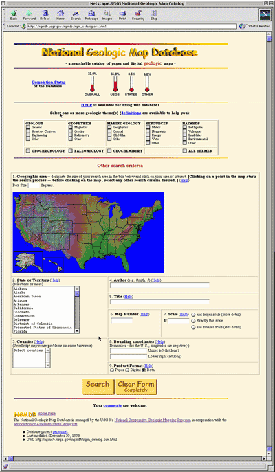
As already noted, the map catalog is the most fundamental aspect of this project. It provides users with a listing of maps specific to their interest, and where to obtain them. If a map is in digital format and available for download, links will be provided to the appropriate site. We have made significant progress toward completion of the map catalog, but still have many maps yet to record. A graphical estimate of the number of maps entered, and remaining, is provided on the catalog search page (figure 1). In 1999, we plan to include nearly all USGS maps in the catalog, and will then work closely with all state geological surveys to include their maps. This effort will be aided by a newly-developed web-based data entry form. This form enables our cooperators in the state geological surveys and university libraries to contribute map records directly into the catalog.
|
|
|
Figure 1. The National Geologic Map Database's map catalog search page. This page contains the catalog search form and completion status. (Available at http://ngmdb.usgs.gov/ ngmdb/ ngm_catalog.ora.html) |
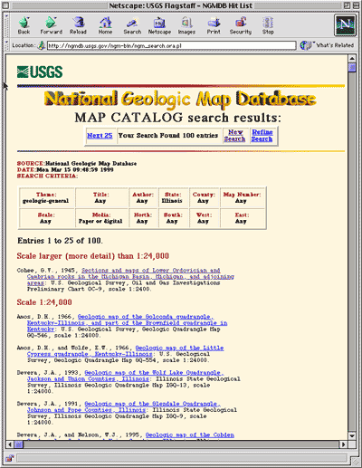
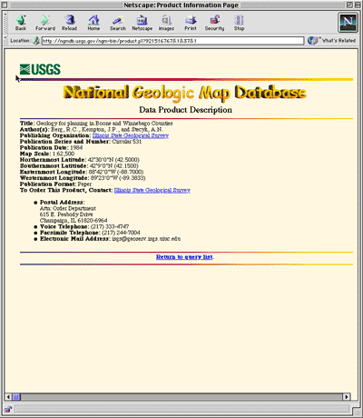
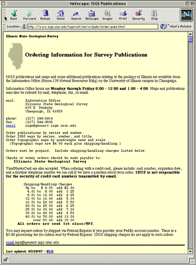
To conduct a catalog search, the user specifies the search criteria (figure 1). These criteria may include one or more of the following: map theme, geographic area, state, county, author, title, map scale(s), map series number, bounding coordinates, or product format. The NGMDB returns a "hit list" of maps that meet the criteria; the list is provided in a standard bibliographic format and sorted by map scale, author, and date (figure 2). The user may download to a file the entire list, if they choose. When the user selects a map from the list, a Product Description Page is shown (figure 3). This page contains typical bibliographic information and links to the agency that produced the map. If the agency has a map sales web page, we link to it. Figure 4 shows the Illinois State Geological Survey product ordering web page, which is linked from the Product Description Page.
|
|
|
Figure 2. The NGMDB returns a "hit list" of maps that meet the search criteria; the list is provided in a standard bibliographic format and sorted by map scale, author, and date. |
|
|
|
|
|
Figure 3. When the user selects a map from list in figure 2, this Product Description Page is shown. This page contains typical bibliographic information and links to the agency that produced the map. |
|
|
|
|
|
Figure 4. From the Product Description Page (figure 3), the user may want to find product-ordering information. By selecting the link for the line "To order this product, contact:", they are sent to this page from the Illinois State Geological Survey web site. |
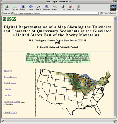
In the near future, the catalog will contain most of the newer USGS map publications that are available in digital format. For these products, the Product Description Page will provide links to the metadata and to the map data online. Figure 5 shows a USGS site where online map data and supporting information are available directly from the Product Description Page.
|
|
|
Figure 5. A USGS web site where online map data and supporting information are available directly from the Product Description Page. (Available at http://pubs.usgs.gov/ dds/dds38) |
We have received from users various suggestions for improving the design and content of the map catalog pages, and have made the appropriate changes. For example, Charlotte Derksen (Branner Library, Stanford University) suggested that, especially while the catalog is incomplete, we provide a listing of map series that are found in the catalog. This page, the "completion status of the map catalog" is now provided. We are now working to implement a suggestion that the Product Description Page include a notification if the map is "in stock" and available for purchase, or "out or print" and available at libraries only.
SOLICITING ADVICE AND COMMENTS
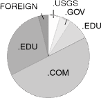
The NGMDB is designed as a tool useable by a wide audience ranging from the research geologist to the general public. Website usage statistics, while notoriously difficult to interpret, can at least provide a general summary of the user community. As shown in figure 6, the NGMDB is used mostly by the general public and the private sector, to help answer a variety of general and specific questions about geology and the availability of maps. Understanding their needs and interests is critical to the success of the NGMDB, just as it is for any library or public-service venture.
|
|
|
Figure 6. Classification of NGMDB users, derived from website logs. |
|
We actively solicit advice from the public, through a web-based comment form, and through formal and informal presentations and discussions with potential users. For example, in May, 1998, we held a public forum to evaluate the development plan for the National Geologic Map Database. Forum attendees represented various groups that use geoscience maps, including private industry, non-governmental organizations, K-12 and undergraduate education, libraries, state and local government, professional and trade associations, academia, and the federal government. Their advice was woven into the NGMDB work plan, and has helped justify additional effort on certain aspects of the plan, specifically the development of standardized, digital geologic maps.
Almost unanimously, forum attendees urged the NGMDB project to accelerate completion of the map catalog, and then to provide more access to digital geologic maps. Implementation of advanced techniques for web-based, interactive display and query of maps was seen as a relatively low priority. We were urged to develop closer ties to the American Geological Institute (specifically, to their GEOREF database) and the Alexandria Digital Library project. Preliminary discussions with these groups have now been completed, and we are working to develop useful links or data-sharing with those two important databases. The results of this forum will be published in 1999 as a USGS Fact Sheet.
SUMMARY
The National Geologic Map Database is intended to serve the public, as a reference tool and as a mechanism for coordinating the development of standards. We are trying to improve public access to the scientific information needed to help address societal issues. In the NGMDB project, and especially within the map catalog, the library community has the expertise needed to significantly improve the content and style of information delivery. We encourage you to contact us, to offer advice. Specific questions about the map catalog's content (or offers of assistance!) should be directed to the coordinator of that effort, Nancy Blair (USGS Western Region Chief Librarian, [email protected]).
References
Bernknopf, R.L.; Brookshire, D.S.; Soller, D.R.; McKee, M.J.; Sutter, J.F.; Matti, J.C.; Campbell, R.H., 1993, Societal value of geologic maps: U.S. Geological Survey Circular, no. 1111, 53 p.
Soller, D.R.; Berg, T.M., 1998, Progress toward development of the National Geologic Map Database. In D. R. Soller, editor, Digital mapping techniques `98-Workshop proceedings: U. S. Geological Survey Open-file Report, no. 98-487, p. 37-39. (Available at http://pubs.usgs.gov/openfile/of98-487/).
Soller, D.R., and Berg, T.M., 1997, The National Geologic Map Database - A progress report: Geotimes, v. 42, no. 12, p. 29-31. (Available at http://ncgmp.usgs.gov/ngmdbproject/reports/geotimes97.html)
Soller, D.R., and Berg, T.M., 1995, Developing the National Geologic Map Database: Geotimes, v. 40, no. 6, p. 16-18. (Available at http://ncgmp.usgs.gov/ngmdbproject/reports/geotimes95.html)
Return to National Geologic Map Database project
This page is <URL :http://ncgmp.usgs.gov/ngmdbproject/reports/gisproc98.html>
Page maintained by Dave Soller ([email protected])
Nov. 15, 1999