

- Usage in publication:
-
- Yates sandstone
- Modifications:
-
- Original reference
- Dominant lithology:
-
- Sandstone
- AAPG geologic province:
-
- Permian basin
Summary:
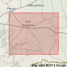
Pg. 487, 488. In Yates field, upper division of Permian is known as "Anhydrite series" and ranges in thickness from 650 to 750 feet. Yates is 50-foot sandstone that occurs 100 to 150 feet below top of Anhydrite series and from 500 to 550 feet above top of "brown lime," topmost member of "Big lime" in this field.
Source: US geologic names lexicon (USGS Bull. 1200, p. 4318).

- Usage in publication:
-
- Yates sand
- Modifications:
-
- Overview
- AAPG geologic province:
-
- Permian basin
Summary:
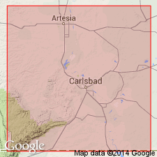
Yates sand. A subsurface sand, of Permian age and 50 to 60+ feet thick, lying 400+/- feet below eroded top of Permian in Yates oil pool, Pecos County, western Texas. Also known locally as Smith sand. Oil-bearing limestones lying at approximate horizon of this sand have been called Yates lime and Yates limestone.
Source: US geologic names lexicon (USGS Bull. 896, p. 2382).
- Usage in publication:
-
- Yates sand
- Modifications:
-
- Areal extent
- AAPG geologic province:
-
- Permian basin
Summary:
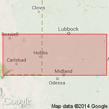
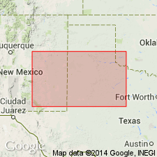
Pg. 1706. Yates sand has been traced from subsurface to surface outcrop and top of Yates mapped from Carlsbad to McKittrick Canyon. Subdivision of Whitehorse-Capitan is simplified. From top downward, it is subdivided into Carlsbad, Yates, Seven Rivers, and Queen. This involves redefinition of the Carlsbad.
Source: US geologic names lexicon (USGS Bull. 1200, p. 4318).
- Usage in publication:
-
- Yates sand
- Modifications:
-
- Revised
- Areal extent
- AAPG geologic province:
-
- Permian basin
Summary:
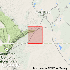
Yates sand areally extended into report area and revised. The Whitehorse is raised to group rank and divided into (ascending) Grayburg formation (new), Queen formation, Seven Rivers formation, Yates sand, and Tansill formation. In this report a geologic section was compiled from well logs in Eddy and Lea Counties, New Mexico, and Andrews, Martin, Dawson, Scurry, and Fisher Counties, Texas, in the Permian basin; it shows chiefly the continuity of the formations of Whitehorse group from the east side to the west side of the basin. These formations can be recognized in the subsurface by their contrasting lithologies --a principally chemical formation alternating with a principally clastic formation. Structural features existing at the time of deposition influenced the composition of these formations, yet these 5 formations can be traced across all structural features. Yates sand overlies Seven Rivers formation and underlies Tansill formation. Age of Whitehorse group is Permian.
Source: Modified from GNU records (USGS DDS-6; Denver GNULEX).
- Usage in publication:
-
- Yates formation*
- Modifications:
-
- Mapped
- AAPG geologic province:
-
- Permian basin
Summary:
Yates formation included in Carlsbad group. Overlies Seven Rivers formation; underlies Tansill formation. [Age is Late Permian (Guadalupe).]
Source: US geologic names lexicon (USGS Bull. 1200, p. 4318).
- Usage in publication:
-
- Yates Formation
- Modifications:
-
- Revised
- Reference
- Dominant lithology:
-
- Sandstone
- Siltstone
- Anhydrite
- AAPG geologic province:
-
- Permian basin
Summary:
Yates Formation of Artesia Group. Term Artesia Group (new) used in preference to Whitehorse Group in Eddy County, New Mexico. Assigned to lower part of group. Overlies Seven Rivers Formation; underlies Tansill Formation (both of Artesia Group). Age is Late Permian (late Guadalupian).
Reference well: depth-interval 1,144 to 1,405 ft, Humble Oil and Refining Company Federal Bogle No. 1 well, sec. 30, T. 16 S., R. 30 E., Eddy Co., NM, where Yates is composed of sandstone, siltstone, and anhydrite. The sandstone has large rounded, frosted quartz grains scattered in a matrix of fine- to very fine-grained sand.
Source: GNU records (USGS DDS-6; Denver GNULEX); US geologic names lexicon (USGS Bull. 1200, p. 4318).
For more information, please contact Nancy Stamm, Geologic Names Committee Secretary.
Asterisk (*) indicates published by U.S. Geological Survey authors.
"No current usage" (†) implies that a name has been abandoned or has fallen into disuse. Former usage and, if known, replacement name given in parentheses ( ).
Slash (/) indicates name conflicts with nomenclatural guidelines (CSN, 1933; ACSN, 1961, 1970; NACSN, 1983, 2005, 2021). May be explained within brackets ([ ]).