

- Usage in publication:
-
- Wyoming formation
- Wyoming group
- Modifications:
-
- Original reference
- AAPG geologic province:
-
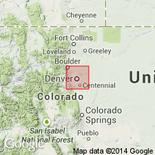
- Denver basin
Summary:
(Chapter II, Mesozoic geology, by G.H. Eldridge, p. 51-151.) Wyoming formation. Prominent series of brilliant red conglomerates, sandstones, and shales, with thin limestones and gypsums in upper part. Constitutes well-known Red Beds of Rocky Mountains region. Commonly referred to Triassic. In Denver field they rest directly and unconformably on ancient crystalline rocks, although in many other localities there intervene thousands of Paleozoic measures --Permian(?), Carboniferous, Silurian, and Cambrian. Thickness 500 to 3,000 feet. In Denver basin consists of an upper division and a lower division. The upper division consists of (descending): (1) fine-grained sandstone, often massive, pink and brown, persistent, 15 to 25 feet; (2) gray, yellow, green, pink, and lilac clays, gypsiferous and calcareous, especially 40 feet below top, 125 to 175 feet; (3) clays more arenaceous than those above, transitional in color from grays above to prevaillingly brick reds below, 150 to 200 feet; (4) sandstones and shales alternating, brick red to pink, white dots, 50 feet; (5) sandstones and shales, 60 feet; and (6) sandy and argillaceous shales, brick red, with narrow bands of white crystalline limestone, 75 feet. The lower division is divided into "Creamy" sandstone at top and Red Beds below. The "Creamy" sandstone, named for its color, is 200 to 400 feet thick, and consists of quartzose sandstone, conglomeratic at base, with two sandy limestone bands in lower part and round ferruginous concretions near top. The Red Beds consist of 270 to 2,000 feet of conglomerates, sandstones, and shales (chiefly conglomerates and sandstones), of red color, the basal 5 to 20 feet nearly everywhere composed of coarse subangular fragments of adjacent granite, gneiss, or schists, usually loosely agglomerated, with small admixture of sand which in places shades to red arenaceous mud.
Named for widespread development in Wyoming, but application of name in literature has been restricted to eastern CO.
Source: US geologic names lexicon (USGS Bull. 896, p. 2378-2379).
- Usage in publication:
-
- Wyoming formation*
- Modifications:
-
- Areal extent
- Revised
- AAPG geologic province:
-
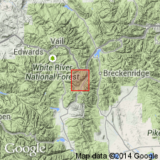
- Eagle basin
Summary:
Overlies the Jacque Mountain limestone (first published use), an unranked unit in the Maroon formation regarded as upper Carboniferous. Mapped area (geologic map) represents a geographic extension of the name into eastern part of Tenmile quad, Summit Co, CO, Eagle basin. Is the youngest (except for alluvium) sedimentary unit mapped. Name Wyoming formation applied because of correlation with rocks of this type in Rocky Mountain region and because of petrologic character. Is 1,500 ft thick. Consists of brick-red sandstone and thin shales. A few limestone beds. Sandstone is coarse to conglomeratic, and is composed of Archean debris. Feldspar and mica present in addition to quartz thought to be Triassic. Shown as Juratrias on geologic map. Permian rocks may be present in unit too.
Source: GNU records (USGS DDS-6; Denver GNULEX).

- Usage in publication:
-
- Wyoming formation†
- Wyoming group†
- Modifications:
-
- Overview
Summary:
Is now [ca. 1938] divided into (descending) Lykins formation ("Upper Wyoming" of Eldridge); Lyons sandstone restricted; Ingleside formation; and Fountain formation; the latter 3 representing "Lower Wyoming" of Eldridge. The Lykins formation is now considered to be of Triassic(?) and probably Permian age; the Lyons sandstone restricted of Permian age; and the Ingleside and Fountain of Pennsylvanian age.
Source: US geologic names lexicon (USGS Bull. 896, p. 2378-2379).
For more information, please contact Nancy Stamm, Geologic Names Committee Secretary.
Asterisk (*) indicates published by U.S. Geological Survey authors.
"No current usage" (†) implies that a name has been abandoned or has fallen into disuse. Former usage and, if known, replacement name given in parentheses ( ).
Slash (/) indicates name conflicts with nomenclatural guidelines (CSN, 1933; ACSN, 1961, 1970; NACSN, 1983, 2005, 2021). May be explained within brackets ([ ]).