

- Usage in publication:
-
- Wilcox formation*
- Modifications:
-
- Overview
- AAPG geologic province:
-
- Mid-Gulf Coast basin
Summary:
Name Wilcox formation has been adopted by the USGS to include the complex mass of sands, clays, lignites, marls, etc. between Porter Creek clays below and Tallahatta buhrstone (of Claiborne group) above. Thickness (estimated from width of outcrop) is 750 to 800 ft.
Source: GNU records (USGS DDS-6; Reston GNULEX).
- Usage in publication:
-
- Wilcox group*
- Modifications:
-
- Revised
- AAPG geologic province:
-
- Gulf Coast basin
Summary:
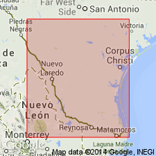
Divided into the Indio formation (new) at base, the Carrizo sandstone, and Bigford formation (new) at top. These formations are mapped (geologic map) in Webb, Dimmit, Maverick, Zavalla, and Uvalde Cos, TX in the Gulf Coast basin. Unconformably overlies the Midway formation. Underlies Mount Selman formation of Claiborne group. Eocene age.
Source: GNU records (USGS DDS-6; Denver GNULEX).

- Usage in publication:
-
- Wilcox group*
- Modifications:
-
- Named
- Dominant lithology:
-
- Lignite
- AAPG geologic province:
-
- Mid-Gulf Coast basin
Summary:
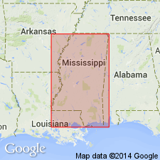
The term Wilcox as the geographic name to replace the nongeographic term "Lignitic" in its typical region (AL and MS) was formally adopted by the USGS on March 23, 1905, in connection with reports then in preparation on geology and underground water resources of MS (under supervision of E.C. Eckel) and AL (E.A. Smith). This name was selected after correspondence (by E.C. Eckel) with the State Geologist of AL (E.A. Smith), and type locality was specifically stated in the record to be Wilcox Co., AL, "which affords good exposures of the entire lignitic section." At the time the name Wilcox was adopted, the Survey also had in course of preparation (by A.C. Veatch) a report (USGS Prof. Paper 46) on Geology and underground water resources of LA and northern AR and it was decided that if the author of that report were unwilling to correlated the "Lignitic" of that area with the typical "Lignitic" of AL, the name Sabine would be acceptable west of the Mississippi River. The Water Supply Paper was published August 20, 1906, and the Bulletin was delivered September 25, 1906. E.A. Smith's report was published by the Alabama Geological Survey in 1907.
Source: GNU records (USGS DDS-6; Reston GNULEX).
- Usage in publication:
-
- Wilcox group*
- Modifications:
-
- Areal extent
- AAPG geologic province:
-
- Ouachita folded belt
Summary:
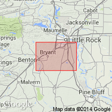
Pg. 11 (fig. 4), 38-58. Wilcox Group. Described in Arkansas bauxite region. Divided into (ascending) Berger formation, Saline formation, and Detonti sand (all new). Thickness as much as 1,209 feet. Unconformably overlies Wills Point formation of Midway group. Overlain by variegated clay and sand and thin lignite beds similar to those assigned to Claiborne group in other parts of Arkansas; whether this represents true contact of Wilcox and Claiborne must be decided by later studies. It is possible that Wilcox in Arkansas bauxite region, on lithologic basis, probably should be restricted to Berger formation, but current Arkansas usage is being followed in this report. Lower Eocene.
Source: US geologic names lexicon (USGS Bull. 1200, p. 4226-4233).

- Usage in publication:
-
- Wilcox Group, undivided
- Modifications:
-
- Mapped 1:250k
- Dominant lithology:
-
- Clay
- Lignite
- Silt
- Sand
- AAPG geologic province:
-
- Arkla basin
- East Texas basin
- Ouachita folded belt
Summary:
Wilcox Group, undivided. Mostly silty and sandy clay, very thinly bedded to massive, locally cross-bedded, in part carbonaceous, calcareous siltstone and ironstone concretions common, various shades of gray; local beds of clay, lignite, silt, and quartz sand; weathers various shades of gray, brown, yellow, and red; abundant plant fossils; thickness 700+/- feet. Lies below Carrizo Sand and above Paleocene Midway Group. Age is Eocene.
[Mapped in southern part of sheet, in Bowie, Camp, Cass, Franklin, Hopkins, Morris, Red River, and Titus Cos., northeastern TX, and Miller Co., southwestern AR.]
Source: Publication.

- Usage in publication:
-
- Wilcox Group
- Modifications:
-
- Mapped 1:250k
- AAPG geologic province:
-
- East Texas basin
Summary:
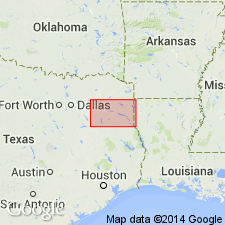
Wilcox Group. Includes (descending) Calvert Bluff Formation, Simsboro Formation, and Hooper Formation (all separately mapped). Lies above Midway Group and below Carrizo Sand. Age is Eocene.
Mapped in Falls, Freestone, Leon, Limestone, Navarro, and Robertson Cos., eastern TX.
Source: Publication.

- Usage in publication:
-
- Wilcox Group
- Modifications:
-
- Mapped 1:250k
- Dominant lithology:
-
- Mudstone
- AAPG geologic province:
-
- Gulf Coast basin
Summary:
Wilcox Group. Mostly mudstone with various amounts of sandstone, lignite, and ironstone concretions. Is glauconitic in uppermost and lowermost parts. Thickness about 1,200 to 1,300 feet. Overlies Midway Group (Eocene) and often in fault contact with it; underlies Carrizo Sand (Eocene). Age is Eocene.
Mapped undivided in Guadalupe, Gonzales, Caldwell, and Bastrop Cos., southeastern TX.
Source: Modified from GNU records (USGS DDS-6; Denver GNULEX).
- Usage in publication:
-
- Wilcox Group
- Modifications:
-
- Mapped 1:250k
- Dominant lithology:
-
- Clay
- Lignite
- Silt
- Sand
- AAPG geologic province:
-
- East Texas basin
- Arkla basin
Summary:
Wilcox Group undivided. Mostly silty and sandy clay, various shades of gray, local beds of clay, lignite, silt, and quartz sand, in part carbonaceous, laminated to massive, locally cross-bedded, weathers to various shades of gray, brown, yellow, and red. Calcareous siltstone and ironstone concretions common. Thickness 500 to 1,000 feet. Occurs below Carrizo Sand and above Wills Point Formation. Abundant plant fossils, a few marine fossils in southeastern part. Age is Eocene.
[Mapped in Anderson, Harrison, Henderson, Hopkins, Marion, Panola, Rains, Rusk, Van Zandt, and Wood Cos., eastern TX.]
Source: Publication.

- Usage in publication:
-
- Wilcox Group, undivided
- Modifications:
-
- Mapped 1:250k
- Dominant lithology:
-
- Mudstone
- Sandstone
- Lignite
- AAPG geologic province:
-
- Gulf Coast basin
- Ouachita folded belt
Summary:
Pamphlet [p. 4]. Wilcox Group, undivided. Mostly mudstone with varying amounts of sandstone and lignite; in uppermost and lowermost parts commonly glauconitic. Mudstone, massive to thin-bedded, some silt and very fine sand laminae, pale brown to yellowish brown in upper part, medium- to dark-gray, weathering yellowish gray in lower part. Sandstone in upper part, medium- to fine-grained, light-gray to pale yellowish brown, in lower part very fine-grained, yellowish brown to moderate brown. Lignite mostly near middle. Thickness about 440 to 1,200 feet. Lower boundary not readily mappable because of gradation into Midway Group (contact taken from sources shown on Index to Geologic Mapping). Underlies Carrizo Sand and younger sediments. Age is Eocene.
[Mapped east of Frio River, in Uvalde, Medina, Bexar, Atascosa, Wilson, and Guadalupe Cos., southern TX. Group represented by Indio Formation west of Frio River. See also entry under Indio.]
Source: Publication.

- Usage in publication:
-
- Wilcox Group
- Modifications:
-
- Mapped 1:250k
- Dominant lithology:
-
- Mudstone
- Sandstone
- Lignite
- AAPG geologic province:
-
- East Texas basin
Summary:
Wilcox Group undivided. Mostly mudstone with various amounts of sandstone, lignite, ironstone concretions, locally glauconitic in uppermost and lowermost parts. Mudstone, massive to thin-bedded, interbedded with laminae of silt and very fine sand, pale brown to yellowish brown in upper part, medium to dark gray in lower part, weathers yellowish brown. Sandstone, medium to fine grained, moderately well-sorted, cross-bedded, lenticular in upper part, units a few inches to 30 feet thick in lower part, light gray to pale yellowish brown and yellowish brown to moderate brown. Lignite mostly near middle of formation, seams 1 to 20 feet thick, brownish black. Abundant plant fossils, a few marine megafossils. Thickness 1,000 to 1,500 feet. Lies above Midway Group. Age is Eocene and Paleocene.
[Mapped in Anderson, Henderson, Navarro, and Van Zandt Cos., eastern TX.]
Source: Publication.

- Usage in publication:
-
- Wilcox Group
- Modifications:
-
- Revised
- AAPG geologic province:
-
- Black Warrior basin
- Mid-Gulf Coast basin
Summary:
Fearn Springs is here reduced in rank, removed from the Wilcox Group, and assigned as uppermost member to the Naheola Formation of the Midway Group in MS. This revises the Wilcox-Midway boundary upward to the Nanafalia-Fearn Springs contact.
Source: GNU records (USGS DDS-6; Reston GNULEX).
- Usage in publication:
-
- Wilcox Group
- Modifications:
-
- Overview
- AAPG geologic province:
-
- South Georgia sedimentary province
Summary:
Midway beds of Applin (1964) are here considered to be sediments of the lower Wilcox Group. Reevaluation of the fauna in Applin's logs indicate that they are actually late Paleocene to early Eocene, not early Paleocene. Lower Wilcox sediments were penetrated in three test wells in Gadsden Co. They are described as green to gray calcareous shales alternating with white to light brown, chalky limestone. No fossils were noted. Undifferentiated early Eocene Wilcox Group sediments are also present in these three test wells in Gadsden Co. These sediments are typically poorly fossiliferous, glauconitic and calcareous quartz sandstones, varying from greenish-gray to gray. As with the Paleocene Wilcox rocks, fossils are sparse or absent.
Source: GNU records (USGS DDS-6; Reston GNULEX).

- Usage in publication:
-
- Wilcox Group*
- Modifications:
-
- Overview
- Age modified
- AAPG geologic province:
-
- Upper Mississippi embayment
Summary:
Designation of this unit as strictly Wilcox is somewhat problematic. Missouri Geological Survey consistently refers to strata above Midway Group and below Mounds Gravel as Wilcox Group since strata were first recognized in southeastern MO by Lamar and Sutton (1930) and Eocene plant species typical of Wilcox were identified by E.W. Berry of U.S. Geological Survey. Wilcox in southeast MO was divided into (ascending) Ackerman Formation, Holly Springs Formation, and locally, the Idalia clay (informal) of the Holly Springs. More recently, divided into (ascending) Old Breastworks Formation, Fort Pillow Sand, and Flour Island Formation. Paleocene-Eocene boundary occurs in Flour Island Formation (Fredericksen and others, 1982). At first appearance, there seems to be close correlation between the two sets of nomenclature. However, from work in Jackson Purchase region of western KY, Olive (1980) describes occurrence of black chert pebbles as characteristic of Eocene Jackson Formation and Claiborne Group, but not of Wilcox Group. Black chert pebbles are common in Holly Springs Formation in MO. Thus, based on lithologic similarities, Holly Springs could be correlative with Jackson Formation and (or) Claiborne Group. This matter remains unresolved. Wilcox Group used in MO following usage of Missouri Geological Survey. Age is changed to Paleocene and Eocene(?) based on problems with correlation.
Source: GNU records (USGS DDS-6; Reston GNULEX).
For more information, please contact Nancy Stamm, Geologic Names Committee Secretary.
Asterisk (*) indicates published by U.S. Geological Survey authors.
"No current usage" (†) implies that a name has been abandoned or has fallen into disuse. Former usage and, if known, replacement name given in parentheses ( ).
Slash (/) indicates name conflicts with nomenclatural guidelines (CSN, 1933; ACSN, 1961, 1970; NACSN, 1983, 2005, 2021). May be explained within brackets ([ ]).