


- Usage in publication:
-
- Weymouth Formation*
- Modifications:
-
- Overview
- AAPG geologic province:
-
- New England province
Summary:
Used as Weymouth Formation, mapped undivided with Braintree Argillite, and both assigned an Early and Middle Cambrian age. Consists of argillite with some rare limestone, and Early and Middle Cambrian faunae, respectively. [Implied age of Weymouth alone is therefore Early Cambrian.]
Source: GNU records (USGS DDS-6; Reston GNULEX).
- Usage in publication:
-
- Weymouth Formation
- Modifications:
-
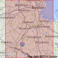
- Areal extent
- AAPG geologic province:
-
- New England province
Summary:
Red and maroon phyllites with a basal limestone bed occurring in the southwest part of the city of Newport, RI, are lithologically comparable to, coeval with, and assigned herein to the Weymouth Formation. These rocks have been previously designated the Pirate Cave Formation (Skehan et al, 1987). Use of the name Pirate Cave Formation and Hoppin Formation, another local name for the Weymouth, should be discontinued as the name Weymouth is preferred for all red, purple, and green mudstones and associated limestones that represent the Lower Cambrian in this region.
Source: GNU records (USGS DDS-6; Reston GNULEX).
- Usage in publication:
-
- Weymouth Formation*
- Modifications:
-
- Overview
- AAPG geologic province:
-
- New England province
Summary:
Weymouth Formation consists of greenish-gray and dark-red slate containing calcareous nodules, and subordinate beds and lenses of argillaceous limestone. Locally converted to hornfels by intrusion of Quincy Granite. At Nahant, MA, contains layer of greenish-white limestone. Lithology is similar to Hoppin Formation at Hoppin Hill, MA, except that lower quartzitic part of section has not been recognized in the Weymouth. No complete section of Weymouth has been described by any worker. Base is not exposed and can only be inferred to be at least 100 m thick (LaForge, 1932). Fossils in Weymouth are largely conoidal forms, but include some olenellids. Age is Early Cambrian. Report includes geologic maps and correlation charts. [Chapters A-J in U.S. Geological Survey Professional Paper 1366 are intended as explanations and (or) revisions to 1:250,000-scale MA State bedrock geologic map of Zen and others (1983).]
Source: GNU records (USGS DDS-6; Reston GNULEX).
For more information, please contact Nancy Stamm, Geologic Names Committee Secretary.
Asterisk (*) indicates published by U.S. Geological Survey authors.
"No current usage" (†) implies that a name has been abandoned or has fallen into disuse. Former usage and, if known, replacement name given in parentheses ( ).
Slash (/) indicates name conflicts with nomenclatural guidelines (CSN, 1933; ACSN, 1961, 1970; NACSN, 1983, 2005, 2021). May be explained within brackets ([ ]).