

- Usage in publication:
-
- Virgin limestone member*
- Modifications:
-
- Original reference
- Dominant lithology:
-
- Limestone
- Shale
- AAPG geologic province:
-
- Great Basin province
Summary:
Pg. 90-92. Virgin limestone member of Moenkopi formation. Earthy greenish-yellow limestone, in 3 thin bands separated by greenish-yellow and reddish-brown shale. Thickness 80 to 160 feet. Lies 400 to 435 feet below Shnabkaib shale member of Moenkopi and 355 to 610+/- feet above base of Moenkopi. Age is Early Triassic. [See also USGS Prof. Paper 129-D, 1922.]
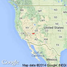
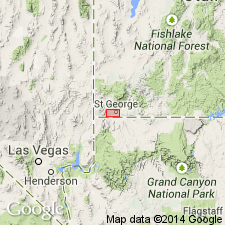
Named from Virgin City [Virgin on map], Washington Co., southwestern UT, where it is well exposed. Extends into northwestern AZ.
Two sections measured: (1) at Smith's Mesa, 3 miles north of Virgin City, where it is 80 feet thick; and (2) Harrisburg dome, 8 miles east of Saint George, Utah, where it is 160 feet thick.
Source: US geologic names lexicon (USGS Bull. 896, p. 2255); supplemental information from GNU records (USGS DDS-6; Denver GNULEX, Menlo GNULEX).
- Usage in publication:
-
- Virgin formation
- Modifications:
-
- Revised
- Biostratigraphic dating
Summary:
Pg. 971-1006; see also GSA Bull., v. 63, no. 12, pt. 2, p. 1342, 1952 [abs.], and Plateau, v. 25, no. 4, p. 69-79, 1953. Virgin formation of Moenkopi group. Rank raised to formation in Moenkopi group herein rank raised. Boundary of formation is placed at base of lowest limestone layer; this limestone rests disconformably on either "lower red member" of Moenkopi or upon alpha member of Kaibab. Thickness as much as 213 feet. [Age is Early Triassic, based on fossils.]
Source: US geologic names lexicon (USGS Bull. 1200, p. 4088).
- Usage in publication:
-
- Virgin Limestone Member*
- Modifications:
-
- Areal extent
- AAPG geologic province:
-
- Great Basin province
- Plateau sedimentary province
Summary:
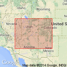
Is a member of the Moenkopi Formation that thickens westward across central Kane and Washington Cos, southern UT and across central Coconino and Mohave Cos, northern AZ into southeast NV in the Plateau sedimentary and Great Basin provinces. Eastern limit at Colorado River; O isopach trends northwest. Thickest section is 213 ft. Isopach map. Composed of alternation of gray, aphanitic to very finely crystalline, horizontally laminated to thick-bedded limestone in beds that range from several inches to 20 ft thick, and gray siltstone with very fine grained mica. Limestone is ledge-forming, locally has contorted bedding, penecontemporaneous slumping, cross-stratification, and mudcracks. Marine fossils: crinoids, pelecypods, gastropods, worms, crustaceans, and cephalopods. Contains ammonite TIROLITES. Lower contact placed at base of lowest limestone. Upper contact placed at top of uppermost limestone. Overlies lower red member of Moenkopi. Underlies middle red member of Moenkopi. Measured sections. Nomenclature chart. Of Early Triassic age.
Source: GNU records (USGS DDS-6; Denver GNULEX).
- Usage in publication:
-
- Virgin Limestone Member*
- Modifications:
-
- Overview
- AAPG geologic province:
-
- Great Basin province
Summary:
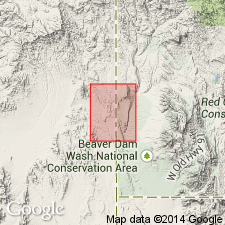
Mapped as third member from base of five members of Moenkopi Formation. Exposed in northeast corner of quad, Washington Co, UT and in northwest corner of quad, Lincoln Co, NV, Great Basin province. Consists of yellowish gray silty limestone, shale, and platy bioclastic limestone. Described in adjacent Dodge Spring quad (Anderson and Hintze, 1992, USGS GQ-1721). Unit is 150 m thick. Younger than lower red member of Moenkopi; conformably underlies Shnabkaib Member of Moenkopi. Early Triassic age.
Source: GNU records (USGS DDS-6; Denver GNULEX).
For more information, please contact Nancy Stamm, Geologic Names Committee Secretary.
Asterisk (*) indicates published by U.S. Geological Survey authors.
"No current usage" (†) implies that a name has been abandoned or has fallen into disuse. Former usage and, if known, replacement name given in parentheses ( ).
Slash (/) indicates name conflicts with nomenclatural guidelines (CSN, 1933; ACSN, 1961, 1970; NACSN, 1983, 2005, 2021). May be explained within brackets ([ ]).