

- Usage in publication:
-
- Torrey sand [member]
- Modifications:
-
- Named
- Dominant lithology:
-
- Sand
- AAPG geologic province:
-
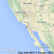
- Peninsular Ranges province
Summary:
Unit is named as the Torrey sand [member] of La Jolla formation. Consists of sand, usually coarse, porous, and unconsolidated. Color is usually white to light brown. Is highly cross-bedded. Sand is clean, moderately well-rounded grains of quartz with varying amounts of feldspar, some muscovite and biotite and minor amounts of ferromagnesians. Thickness is more than 200 feet. Grades into overlying Rose Canyon shale [member] and into underlying Delmar sand [member]. Age is Eocene.
Source: GNU records (USGS DDS-6; Menlo GNULEX).
- Usage in publication:
-
- Torrey Sandstone*
- Modifications:
-
- Adopted
- Revised
- AAPG geologic province:
-
- Peninsular Ranges province
Summary:
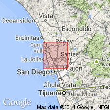
Torrey Sand Member of La Jolla Formation of Hanna (1926) is adopted and raised in rank to Torrey Sandstone of La Jolla Group. Is exposed from approximately 5 km north of Encinitas to Torrey Pines State Park 20 km south, and from coast to about 8 km inland. Has maximum thickness of 60 m. Although unit contains few poorly preserved fossils, its middle Eocene age is firmly established by its interfingering relationship with the Ardath Shale of the La Jolla Group.
Source: GNU records (USGS DDS-6; Menlo GNULEX).
For more information, please contact Nancy Stamm, Geologic Names Committee Secretary.
Asterisk (*) indicates published by U.S. Geological Survey authors.
"No current usage" (†) implies that a name has been abandoned or has fallen into disuse. Former usage and, if known, replacement name given in parentheses ( ).
Slash (/) indicates name conflicts with nomenclatural guidelines (CSN, 1933; ACSN, 1961, 1970; NACSN, 1983, 2005, 2021). May be explained within brackets ([ ]).