

- Usage in publication:
-
- Sunnyside tuff*
- Modifications:
-
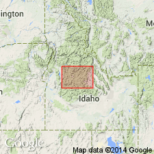
- Areal extent
- AAPG geologic province:
-
- Idaho Mountains province
Summary:
An informal term in the Challis Volcanic Group (rank raised) that was used formerly only in the Thunder Mountain mining district is extended throughout the Thunder Mountain cauldron complex, Valley Co, ID, Idaho Mountains province. Has yielded dates of 47.7 +/-1.6, 46.3 +/-1.1 and 46.3 +/-1.0 Ma from biotite and sanidine (K-Ar method), or Eocene age.
[Challis Volcanic Group conflicts with nomenclature guidelines stating a group [or supergroup] name combines a geographic name with the term "group," [or "supergroup,"] and no lithic designation is included (ACSN, 1961, 1970; NACSN, 1983, 2005, 2021).]
Source: GNU records (USGS DDS-6; Denver GNULEX).
For more information, please contact Nancy Stamm, Geologic Names Committee Secretary.
Asterisk (*) indicates published by U.S. Geological Survey authors.
"No current usage" (†) implies that a name has been abandoned or has fallen into disuse. Former usage and, if known, replacement name given in parentheses ( ).
Slash (/) indicates name conflicts with nomenclatural guidelines (CSN, 1933; ACSN, 1961, 1970; NACSN, 1983, 2005, 2021). May be explained within brackets ([ ]).