

- Usage in publication:
-
- Roxy formation*
- Modifications:
-
- Named
- Dominant lithology:
-
- Volcanics
- AAPG geologic province:
-
- Cascades province
Summary:
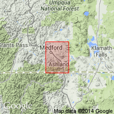
Named after Roxy Ann, well-known knob east of Medford, Jackson Co, OR. Named applied to sequence of flows, flow breccias, and coarse agglomerates that comprise lower part of Little Butte volcanic series (new). Base of formation is irregular and transitional with flows and water-laid pyroclastic rocks in upper part of Colestin formation (new); hence, base is defined as top of uppermost layer of water-laid pyroclastic rocks that are succeeded by at least 100 ft of flows with or without interlayered nonwater-laid pyroclastic rocks. Underlies Wasson formation (new). Age is early Oligocene based on leaf prints found in sec.24 T35S R1W, Medford 30' quad.
Source: GNU records (USGS DDS-6; Menlo GNULEX).
- Usage in publication:
-
- Roxy formation*
- Modifications:
-
- Mapped
- AAPG geologic province:
-
- Cascades province
Summary:
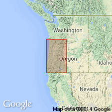
Mapped with unnamed andesite flows and breccia in area near Medford, OR. Age given for unnamed flows and Roxy formation (undivided) is Oligocene and early Miocene.
Source: GNU records (USGS DDS-6; Menlo GNULEX).
- Usage in publication:
-
- Roxy Formation
- Modifications:
-
- Revised
- Geochronologic dating
- AAPG geologic province:
-
- Cascades province
Summary:
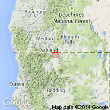
Included as middle formation (of 3) in Western Cascades Group. In northern CA, Roxy Formation consists of about 60% mafic lava flows. Flows are interbedded with volcaniclastic sedimentary deposits including mudflow breccia, conglomerates, and fluvial sands and silts. Divided into three "informal stratigraphic members" (ascending): Iron Gate (350 to 550 m thick), Soda Springs (0 to 125 m thick), and Camp Creek (250 to 300 m thick). Fission track age of about 27 Ma was obtained from Soda Springs. Roxy Formation overlies Colestin Formation; underlies Wasson Formation (both in Western Cascades Group). Geologic sketch map of portion of Copco 15' quad shows distribution of "informal" members and age of Roxy Formation to be late Oligocene.
Source: GNU records (USGS DDS-6; Menlo GNULEX).
For more information, please contact Nancy Stamm, Geologic Names Committee Secretary.
Asterisk (*) indicates published by U.S. Geological Survey authors.
"No current usage" (†) implies that a name has been abandoned or has fallen into disuse. Former usage and, if known, replacement name given in parentheses ( ).
Slash (/) indicates name conflicts with nomenclatural guidelines (CSN, 1933; ACSN, 1961, 1970; NACSN, 1983, 2005, 2021). May be explained within brackets ([ ]).