

- Usage in publication:
-
- Ridgely sandstone member
- Modifications:
-
- Named
- Dominant lithology:
-
- Sandstone
- AAPG geologic province:
-
- Appalachian basin
Summary:
Name Ridgely sandstone member introduced for top member of Oriskany formation. Unit consists of calcareous sandstone, which passes into an arenaceous limestone. Thickness ranges from 50 to 250 ft. Closely resembles Oriskany of NY in lithology and fauna. Overlies Shriver chert member of Oriskany and unconformably underlies Romney formation, which contains Onondaga fauna in basal beds. Named for Ridgely, WV [later changed to Ridgeley].
Source: GNU records (USGS DDS-6; Reston GNULEX).
- Usage in publication:
-
- Ridgeley sandstone*
- Modifications:
-
- Areal extent
- AAPG geologic province:
-
- Appalachian basin
Summary:
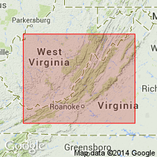
Ridgeley sandstone is identified at Petersburg, WV; 4 mi west of Wardensville, WV; 3 mi south of Wardensville; near Franklin, WV; near Monterey, VA, near McDonald, VA; west of Warm Springs VA; east of Warm Springs; west of Hot Springs, VA; west of Healing Springs, VA; and near Gala, VA.
Source: GNU records (USGS DDS-6; Reston GNULEX).
- Usage in publication:
-
- Ridgeley Sandstone
- Modifications:
-
- Areal extent
- Overview
- AAPG geologic province:
-
- Appalachian basin
Summary:
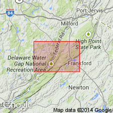
Ridgeley Sandstone mapped as upper member of Oriskany Group in northwestern NJ. Unit described as medium-gray, medium- to thick-bedded quartz-pebble conglomerate and coarse quartz sandstone. Sand grains are moderately well sorted and subrounded. Rock has a carbonate cement and contains abundant brachiopods. Unit first occurs west of Peters Valley and thickens to the southwest. Thickness ranges from 0 to 32 ft. Overlies Shriver Chert of Oriskany Group; underlies Esopus Formation. Age is Early Devonian.
Source: GNU records (USGS DDS-6; Reston GNULEX).
For more information, please contact Nancy Stamm, Geologic Names Committee Secretary.
Asterisk (*) indicates published by U.S. Geological Survey authors.
"No current usage" (†) implies that a name has been abandoned or has fallen into disuse. Former usage and, if known, replacement name given in parentheses ( ).
Slash (/) indicates name conflicts with nomenclatural guidelines (CSN, 1933; ACSN, 1961, 1970; NACSN, 1983, 2005, 2021). May be explained within brackets ([ ]).