

- Usage in publication:
-
- Queantoweap sandstone
- Modifications:
-
- Named
- Dominant lithology:
-
- Sandstone
- AAPG geologic province:
-
- Great Basin province
- Plateau sedimentary province
Summary:
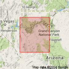
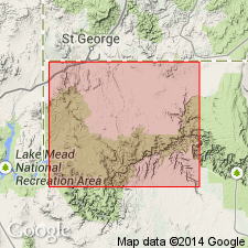
Named for the Queantoweap valley. Type section is on east side of valley between the upper and lower lava flows. Is well exposed on North Grand Wash Cliffs to area east of South Hurricane Cliffs, Mohave Co, AZ in the Plateau sedimentary province and west to the Virgin Mountains of AZ and adjoining NV, Great Basin province. Overlies Pakoon limestone (named) in western sections. Overlies Callville limestone (restricted) east of pinchout of Pakoon. Underlies and intertongues with Hermit shale. Tongues out eastward into the redbeds of the Supai formation. Cross section. Measured sections. Consists of massive ledge- and cliff-forming, cross-bedded, gray to pink, calcareous to slightly calcareous sandstone. Contact with Pakoon is sharp. Upper contact with Hermit is transitional through a range of 5 to 50 ft. Is 393+ ft thick at Hurricane Cliffs, 645 ft thick at North Grand Wash Cliffs, 400+ ft thick in the North Virgin Mountains. Probably increases in thickness northward. Assigned to the Early Permian.
Source: GNU records (USGS DDS-6; Denver GNULEX).
- Usage in publication:
-
- Queantoweap Sandstone
- Modifications:
-
- Not used
Summary:
Seems to be the same unit as the Esplanade Sandstone, upper formation of the Supai Group. Name Queantoweap not recognized in this report.
Source: GNU records (USGS DDS-6; Denver GNULEX).
- Usage in publication:
-
- Queantoweap Sandstone*
- Modifications:
-
- Overview
- AAPG geologic province:
-
- Great Basin province
Summary:
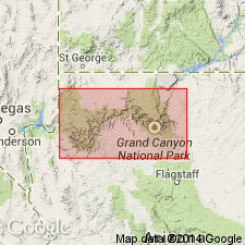
Mapped; best exposed on flanks of Scarecrow Peak, in northeast part of quad, Washington Co, UT and Lincoln Co, NV; also exposed in northwest part of quad and in central part of southwest quarter of quad, Lincoln Co, NV, Great Basin province. Consists of orange-pink fine-grained quartz sandstone that weathers yellowish to reddish brown; cross-bedding and ripplemarks are common. Unit is thin- to medium-bedded and forms slabby talus slopes. Up to 500 m thick. Conformably overlies Bird Spring Formation; conformably underlies Seligman Member of Toroweap Formation. Early Permian age.
Source: GNU records (USGS DDS-6; Denver GNULEX).
- Usage in publication:
-
- Queantoweap Sandstone*
- Modifications:
-
- Areal extent
- Overview
- AAPG geologic province:
-
- Great Basin province
- Plateau sedimentary province
Summary:
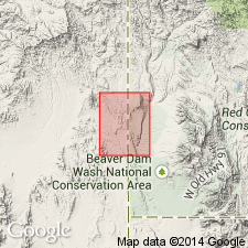
Clarifies nomenclature of Lower Permian clastic units between Wolfcampian Pakoon Limestone and Leonardian Toroweap Formation in northwest AZ, southeast NV, and southwest UT. Where the lowermost part of this sequence intertongues with the underlying Pakoon Limestone, the unit is called the Esplanade Sandstone. Where intertonguing does not occur the name Queantoweap Sandstone should be used. Queantoweap is used in Virgin Mountains, Beaver Dam Mountains, and Gorge of the Virgin River areas of southeast NV, southwest UT, and northwest AZ, Great Basin and Plateau sedimentary provinces. Upper part of Queantoweap in Beaver Dam Mountains, UT, is stratigraphically equivalent to Hermit Formation (redescribed) in Gorge of the Virgin River and elsewhere in northwestern AZ and southeastern NV. Nomenclatural change occurs approximately at Basin-and-Range - Colorado Plateaus transition which is along Grand Wash Cliffs. Overlies Pakoon; underlies Toroweap. Thickness at Gorge of the Virgin River is 124 m; at Red Pockets Mountain is over 133 m. Comparison of nomenclature previously used in region (fig. 2). Measured sections. Early Permian age.
Source: GNU records (USGS DDS-6; Denver GNULEX).
For more information, please contact Nancy Stamm, Geologic Names Committee Secretary.
Asterisk (*) indicates published by U.S. Geological Survey authors.
"No current usage" (†) implies that a name has been abandoned or has fallen into disuse. Former usage and, if known, replacement name given in parentheses ( ).
Slash (/) indicates name conflicts with nomenclatural guidelines (CSN, 1933; ACSN, 1961, 1970; NACSN, 1983, 2005, 2021). May be explained within brackets ([ ]).