


- Usage in publication:
-
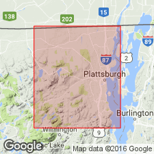
- Potsdam sandstone
- Modifications:
-
- Named
- Dominant lithology:
-
- Sandstone
- AAPG geologic province:
-
- Adirondack uplift
Summary:
Named the Potsdam Sandstone for Potsdam, St. Lawrence Co., NY. Consists of red, yellowish-red, gray, and grayish-white sandstone, made up of grains of sand and held together without cement. Grains are both siliceous and feldspar. Unit is of Late Cambrian age.
Source: GNU records (USGS DDS-6; Reston GNULEX).
- Usage in publication:
-
- Potsdam sandstone
- Modifications:
-
- Revised
- AAPG geologic province:
-
- Adirondack uplift
Summary:
Removed from the top of the Potsdam sandstone the "passage beds" (consisting of between 500 and 600 feet of alternating layers of dolomite and sandstone) and restricted the Potsdam to 800 to 900 feet of beds of very uniform character, mostly coarse grit, white or buff, in massive beds, much of it cross-bedded and ripple marked, with very coarse conglomerates at base.
Source: GNU records (USGS DDS-6; Reston GNULEX).
- Usage in publication:
-
- Potsdam sandstone
- Modifications:
-
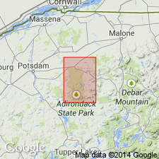
- Areal extent
- AAPG geologic province:
-
- Adirondack uplift
- New England province
Summary:
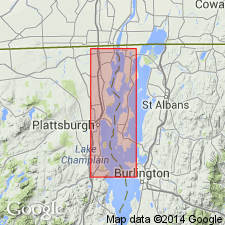
Geographically extended the Potsdam sandstone to VT. The Potsdam is lowest unit of NY Paleozoic section except for beds in thrust plates of Taconic Orogeny. Base of Potsdam in this area is coarse sandstone approaching conglomerate; it grades upward into fairly massive, clean sandstone. In VT, rock has been metamorphosed and is more properly quartzite. Thickness is about 400 feet. At Whitehall, upper beds show transition into Little Falls through interbedded dolomite and sandstone. This transition facies has been called Theresa formation. At Shoreham, in Ticonderoga quad., Little Falls is immediately underlain by 50 feet of massive quartzite without transition; beneath this is 50 feet of interbedded dolomite and sandstone, and then body of Potsdam. If these beds are equivalent to "Theresa" at Whitehall, they bear out suggestion by Emmons that the upper part of the Potsdam grades from sandstone in Champlain region to calcareous sediments in Saratoga region. Upper part of Potsdam is of Franconian age, remainder is presumed to be of Dresbachian age.
Source: GNU records (USGS DDS-6; Reston GNULEX).
- Usage in publication:
-
- Potsdam sandstone*
- Modifications:
-
- Revised
- AAPG geologic province:
-
- Adirondack uplift
Summary:
The Potsdam sandstone is divided into the (ascending) Nicholville conglomerate member and upper unnamed orthoquartzite member. Unnamed member corresponds to the Keeseville sandstone of Emmons (1842). Members may interfinger and may be locally unconformable.
Source: GNU records (USGS DDS-6; Reston GNULEX).
- Usage in publication:
-
- Potsdam sandstone
- Modifications:
-
- Revised
- Age modified
- AAPG geologic province:
-
- Adirondack uplift
Summary:
Revised the Potsdam as the Potsdam sandstone of the Beekmantown group and the Potsdam sandstone of the Saratoga Springs Group in NY. The age of the Potsdam is considered as Late Cambrian and Early Ordovician.
Source: GNU records (USGS DDS-6; Reston GNULEX).
- Usage in publication:
-
- Potsdam Sandstone
- Modifications:
-
- Revised
- AAPG geologic province:
-
- Adirondack uplift
Summary:
Subdivided the Potsdam Sandstone of the Saratoga Springs Group into (ascending) an unnamed basal member, the Ausable Member, and the Keeseville Member in NY. The Potsdam is oldest unit and is overlain by the Theresa Formation of the Saratoga Springs Group.
Source: GNU records (USGS DDS-6; Reston GNULEX).
- Usage in publication:
-
- Potsdam Formation
- Modifications:
-
- Areal extent
- AAPG geologic province:
-
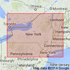
- Appalachian basin
Summary:
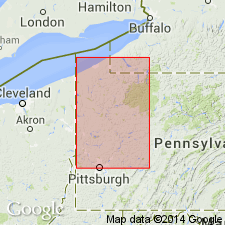
Geographically extended the Potsdam Formation into northwestern PA. Unit overlies Precambrian biotite schist and underlies the Warrior Formation. The Potsdam is considered of Cambrian age.
Source: GNU records (USGS DDS-6; Reston GNULEX).
- Usage in publication:
-
- Potsdam Supergroup
- Modifications:
-
- Revised
- Areal extent
- AAPG geologic province:
-
- Appalachian basin
Summary:
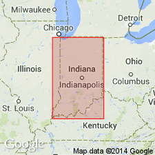
Geographically extended the Potsdam to the subsurface of IN and revised it to the Potsdam Supergroup. Unit includes (ascending) the Mount Simon Sandstone and the Munising Group. Thickness ranges from less than 1,000 feet in eastern IN to greater than 3,000 feet in northwestern IN. Contains high proportion of sandstone, siltstone, and shale while overlying Knox Supergroup is composed largely of carbonate rocks. In northern IN, unit is considered of Dresbachian to Franconian age, while in southern IN it is considered of Dresbachian age, only.
Source: GNU records (USGS DDS-6; Reston GNULEX).

- Usage in publication:
-
- Potsdam Sandstone*
- Modifications:
-
- Areal extent
- Overview
- AAPG geologic province:
-
- Adirondack uplift
Summary:
Paleozoic cover sequence adjacent to Adirondack massif in western part of Glens Falls quad consists of (ascending): Late Cambrian Potsdam Sandstone, Late Cambrian Ticonderoga Formation, Late Cambrian and Early Ordovician Beekmantown Group (with Whitehall Formation at base), early Middle Ordovician Chazy Group, Middle Ordovician Black River and Trenton Groups, and Mohawk Valley shales (Canajoharie Shale and Snake Hill Formation). Potsdam and Ticonderoga are partly correlative with Danby Formation of Middlebury synclinorium in VT. Beekmantown and part of Chazy correlate directly with limestones and dolomites above Danby. Paleozoic cover sequence is interpreted as a platform sequence. [Text states Beekmantown "as used by Fisher (1984)", but this appears to be an error because Fisher (1984) included Potsdam and Ticonderoga in his Beekmantown. Fisher (1977) abandoned Canajoharie but USGS still recognizes it.]
Source: GNU records (USGS DDS-6; Reston GNULEX).
- Usage in publication:
-
- Potsdam Sandstone*
- Modifications:
-
- Overview
- AAPG geologic province:
-
- Adirondack uplift
Summary:
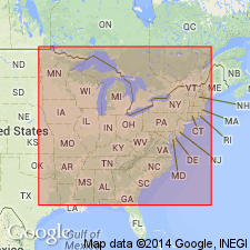
On the correlation chart for Precambrian rocks of the conterminous United States, the Potsdam Sandstone in the northern Laurentian Appalachians is of Late Cambrian age.
Source: GNU records (USGS DDS-6; Reston GNULEX).
For more information, please contact Nancy Stamm, Geologic Names Committee Secretary.
Asterisk (*) indicates published by U.S. Geological Survey authors.
"No current usage" (†) implies that a name has been abandoned or has fallen into disuse. Former usage and, if known, replacement name given in parentheses ( ).
Slash (/) indicates name conflicts with nomenclatural guidelines (CSN, 1933; ACSN, 1961, 1970; NACSN, 1983, 2005, 2021). May be explained within brackets ([ ]).