

- Usage in publication:
-
- Midway stage
- Modifications:
-
- Named
- AAPG geologic province:
-
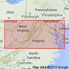
- Mid-Gulf Coast basin
Summary:
Midway used as both a stratigraphic and paleontologic unit. Midway stage includes Matthew's Landing marl (substage), Black Bluff clays (substage), and Midway clay and limestone (substage). Assigned to basal Eocene. [See Wilmarth (1938, US geologic names lexicon, USGS Bull. 896) for clarification.]
Source: GNU records (USGS DDS-6; Reston GNULEX).

- Usage in publication:
-
- Midway stage, formation*, group*
- Modifications:
-
- Overview
- AAPG geologic province:
-
- Mid-Gulf Coast basin
Summary:
The double use of Midway was employed in several publications by different authors, but since 1906 the name has been universally used in Harris's broad or group sense, the name Clayton being employed to designate the basal formation of the group. In present usage, the Midway is a group in AL, MS, southwestern TN, and eastern TX. Midway formation used in northern LA, southern AR, and parts of eastern TX. In AL, group is subdivided into Clayton formation, Sucarnoochee clay, and Naheola formation; in MS and TN, group includes Clayton formation and Porters Creek clay; and in TX, group includes Kincaid formation and Wills Point formation. Unit underlies the Wilcox group and overlies the Cretaceous. The Porters Creek clay of Midway group extends into western KY, southeastern MO, and southwestern IL.
Source: GNU records (USGS DDS-6; Reston GNULEX).

- Usage in publication:
-
- Midway Group
- Modifications:
-
- Mapped 1:250k
- Dominant lithology:
-
- Clay
- Siltstone
- Limestone
- AAPG geologic province:
-
- Arkla basin
- East Texas basin
- Ouachita folded belt
Summary:
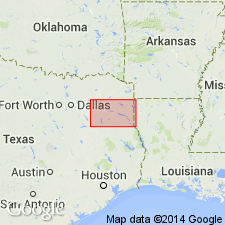
Midway Group. West of Sulphur Springs, Hopkins County, northeastern Texas, divided into (descending) Wills Point and Kincaid Formations [southwestern part of map sheet, in Hopkins and Hunt Cos., northeastern TX]. East of Sulphur Springs the Wills Point and Kincaid are indistinguishable and group is mapped undivided [in southern half of map sheet, in Bowie, Cass, Franklin, Hopkins, Morris, Red River, Titus Cos., northeastern TX, and Miller Co., southwestern AR]. Lies above Upper Cretaceous Navarro Group, undivided, and below Eocene Wilcox Group, undivided. Age is Paleocene.
Source: Publication.

- Usage in publication:
-
- Midway Group
- Modifications:
-
- Mapped 1:250k
Summary:
Midway Group. Includes (descending) Wills Point Formation and Kincaid Formation. Lies above Kemp Clay (Upper Cretaceous) and below Wilcox Group. Age is Eocene.
Mapped in Falls, Freestone, Leon, Limestone, Milam, Navarro, and Robertson Cos., eastern TX.
Source: Publication.

- Usage in publication:
-
- Midway Group
- Modifications:
-
- Mapped 1:250k
- AAPG geologic province:
-
- Gulf Coast basin
Summary:
Midway Group. Comprised of Wills Point Formation and Kincaid Formation. Overlies Navarro Group (Upper Cretaceous); underlies Wilcox Group (Eocene). Age is Eocene.
Mapped undivided in Guadalupe and Caldwell Cos., southeastern TX.
Source: Modified from GNU records (USGS DDS-6; Denver GNULEX).
- Usage in publication:
-
- Midway Group
- Modifications:
-
- Areal extent
- AAPG geologic province:
-
- East Texas basin
Summary:
Midway Group. Age is Eocene. [Age changed from Paleocene (1964 ed.).]
Not separately mapped. [Includes (descending) Wills Point Formation and Kincaid Formation (mapped in Hunt, Rains, and Van Zandt Cos., eastern TX).]
Source: Publication; supplemental information from GNU records (USGS DDS-6; Denver GNULEX).

- Usage in publication:
-
- Midway Group, undivided
- Modifications:
-
- Mapped 1:250k
- Dominant lithology:
-
- Clay
- Sand
- AAPG geologic province:
-
- Gulf Coast basin
- Ouachita folded belt
Summary:
Pamphlet [p. 4]. Midway Group, undivided. Clay and sand; clay, silty, sandy, silt and sand more abundant upward grading to mudstone and sand of Wilcox Group, light-gray to dark-gray; sand, glauconitic to very glauconitic in lower part, argillaceous, poorly sorted, phosphatic nodules and pebbles common in lowermost part, weathers to yellow and yellowish brown soil; thickness about 100 to 400 feet. Upper boundary not readily mappable because of gradation into Wilcox Group (contact taken from sources shown on Index to Geologic Mapping). Overlies Upper Cretaceous Escondido Formation, and Navarro Group and Marlbrook Marl ("upper Taylor marl"), undifferentiated. Age is Eocene.
[Mapped east of Frio River, in Uvalde, Medina, Bexar, Atascosa, Wilson, and Guadalupe Cos., southern TX. Group represented by Kincaid Formation west of Frio River. See also entry under Kincaid.]
Source: Publication.

- Usage in publication:
-
- Midway Group
- Modifications:
-
- Mapped 1:250k
- Dominant lithology:
-
- Clay
- Sand
- Limestone
- Marl
- AAPG geologic province:
-
- East Texas basin
Summary:
Midway Group. Includes (descending) Wills Point Formation and Kincaid Formation. Lies above Kemp Clay and below Wilcox Group. Age is Paleocene. [Age changed from Eocene (1972 ed.).]
[Mapped in Henderson, Hunt, Kaufman, Navarro, and Van Zandt Cos, eastern TX.]
Source: Publication; supplemental information from GNU records (USGS DDS-6; Denver GNULEX).
- Usage in publication:
-
- Midway Group
- Modifications:
-
- Revised
- AAPG geologic province:
-
- Mid-Gulf Coast basin
- Black Warrior basin
Summary:
In MS Fearn Springs removed from Wilcox Group, reduced to member status, and assigned to the top of the Naheola Formation of the Midway Group. This revision changes the Midway-Wilcox boundary in MS. Boundary now placed at the Fearn Springs-Nanafalia contact.
Source: GNU records (USGS DDS-6; Reston GNULEX).
- Usage in publication:
-
- Midway
- Modifications:
-
- Areal extent
- AAPG geologic province:
-
- South Georgia sedimentary province
Summary:
Midway beds of Applin (1964) in Gadsden Co., FL, are here considered to be sediments of the lower Wilcox Group. Reevaluation of the fauna in Applin's logs indicate that they are actually late Paleocene to early Eocene, not early Paleocene.
Source: GNU records (USGS DDS-6; Reston GNULEX).
For more information, please contact Nancy Stamm, Geologic Names Committee Secretary.
Asterisk (*) indicates published by U.S. Geological Survey authors.
"No current usage" (†) implies that a name has been abandoned or has fallen into disuse. Former usage and, if known, replacement name given in parentheses ( ).
Slash (/) indicates name conflicts with nomenclatural guidelines (CSN, 1933; ACSN, 1961, 1970; NACSN, 1983, 2005, 2021). May be explained within brackets ([ ]).