

- Usage in publication:
-
- Mark's Head phase
- Modifications:
-
- Named
- Dominant lithology:
-
- Marl
- AAPG geologic province:
-
- Atlantic Coast basin
Summary:
South Carolina Geol. Survey geognostic map of South Carolina, 1905, advance copies; published in 1908, in South Carolina Geol. Survey Bull., 4th ser., no. 2; Summary of mineral resources of South Carolina, 1907, p. 12, 18, 19.
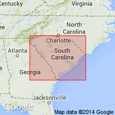
Mark's Head phase. Consists of soft blue marls with characteristic bed of shells embedded in a sandy blue mud matrix. Thickness 27 feet. Extends from Mark's Head, on scarp of Savannah River Swamp, northwest of Porter's Landing, [Effingham County, Georgia], by Raysor's Bridge, South Carolina, and thence below Mount Hope on Santee River, South Carolina. Underlies the Edisto phase (Miocene) and overlies Parachucla phase (Oligocene). Age is Miocene.
Named for Mark's Head on the Savannah River Swamp, Effingham Co., GA.
Source: US geologic names lexicon (USGS Bull. 1200, p. 1303); GNU records (USGS DDS-6; Reston GNULEX).
- Usage in publication:
-
- Marks Head marl
- Modifications:
-
- Revised
- AAPG geologic province:
-
- South GA-North FL sedimentary province
Summary:
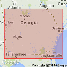
Pg. 60, 363+, map, etc. Marks Head marl. Very sandy greenish or drab clay, fine gray or brownish phosphatic sand and sandy laminated clays with calcareous nodules. Thickness in Georgia 45 feet. Rests unconformably on Alum Bluff formation (Oligocene). Overlain unconformably by Duplin marl (late Miocene), which Sloan erroneously correlated with Edisto marl of Edisto River, South Carolina. Age is early Miocene.
Source: US geologic names lexicon (USGS Bull. 896, p. 1303).
- Usage in publication:
-
- Marks Head marl†
- Modifications:
-
- Abandoned
- AAPG geologic province:
-
- Atlantic Coast basin
Summary:
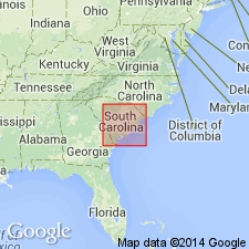
The early Miocene beds in eastern Georgia and South Carolina that have heretofore been called "Marks Head marl," "Edisto marl," "Parchucla shale," "Parchucla marl," and "Combahee shale" are in this report included in Hawthorn formation, a Florida name that is here extended into eastern Georgia and South Carolina. In eastern Georgia, the Hawthorn is represented by †Marks Head marl and part of Alum Bluff formation of Veatch and Stephenson, whose Marks Head marl included, although unwittingly, the †Parachucla marl and †Parachucla shale of Sloan. The Hawthorn is in Georgia, and in most places in South Carolina, overlain by Duplin marl ([late] Miocene), but in a small area in northeast part of Colleton County, South Carolina, it is locally separated from the Duplin by a deposit of [late] Miocene age to which the name Raysor marl is here applied. The Hawthorn rests unconformably on Glendon formation (Oligocene) and older formations; in Georgia and Florida it rests on Tampa limestone ([early] Miocene).
Source: US geologic names lexicon (USGS Bull. 896, p. 1303).
- Usage in publication:
-
- Marks Head Formation
- Modifications:
-
- Revised
- Areal extent
- Biostratigraphic dating
Summary:
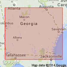
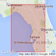
Marks Head Marl of Sloan (1908) is here "reintroduced" as Marks Head Formation and assigned to the Hawthorne Group as the middle formation in GA. Unit occurs in the Savannah River area from northern Effingham Co. southeastward to the offshore, inner continental shelf of GA, and it underlies the coastal area from Chatham Co. to Camden Co. Extends southward into northeastern FL and is tentatively recognized in the subsurface as far north as the Coosawhatchie River in Jasper Co., SC. Unit consists of slightly dolomitic (rarely calcareous), phosphatic, argillaceous sand and sandy clay with scattered beds of dolostone, limestone, and siliceous claystone. Quartz sand is the dominant lithic component and clay is considered a major and characteristic component. Disconformably overlies the Parachucla Formation in most areas. Disconformably underlies the Cypresshead (new name) or Raysor Formations in northern and central Effingham Co., and the Coosawhatchie elsewhere in GA. Correlates with Torreya Formation of western FL and southwestern GA. Environment of deposition was broadly marine, nearshore, inner continental shelf. Age is late early Miocene (Burdigalian) based on Foraminifera and mollusks.
Source: GNU records (USGS DDS-6; Reston GNULEX).
- Usage in publication:
-
- Marks Head Formation
- Modifications:
-
- Principal reference
Summary:
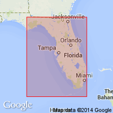
Marks Head Formation is here extended from GA to encompass primarily subsurface middle unit of Hawthorn Group in northern FL. A FL reference section is designated in the Jennings #1 core, W-14219, Clay Co., SE1/4SE1/4 sec. 27, T4S, R24E. Interval is between -29 m and -58 m. Unit is the most lithologically variable formation of Hawthorn in northern FL. It consists of interbedded sands, clays, and dolostones throughout its extent. Carbonate beds in the Marks Head are more common in FL than in GA. Unit reaches a maximum thickness of 40 m in Bradford Co. Disconformably overlies the Penney Farms Formation (new name) and disconformably underlies the Coosawhatchie Formation. Correlates with upper part of the Arcadia Formation (redefined) of southwest FL. Age is late early Miocene.
Source: GNU records (USGS DDS-6; Reston GNULEX).
- Usage in publication:
-
- Marks Head Formation*
- Modifications:
-
- Overview
- Dominant lithology:
-
- Sand
- Clay
- AAPG geologic province:
-
- Atlantic Coast basin
Summary:
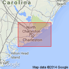
Marks Head Formation as used by Abbott and Huddlestun (1980) is here adopted for use by the U.S.G.S. Consists of two interbedded lithofacies, fine-grained phosphatic quartz sand and "cheese-textured" clay. Found at the surface in GA, but in SC is subsurface only. Thickness up to 15 m in the Charleston area. Underlies Coosawhatchie Formation (rank raised) and overlies Edisto Formation. Age is early Miocene. [Marks Head marl was used in early reports of the USGS, but according to GNU records was abandoned in 1933.]
Source: GNU records (USGS DDS-6; Reston GNULEX).
- Usage in publication:
-
- Marks Head Formation
- Modifications:
-
- Biostratigraphic dating
- AAPG geologic province:
-
- Florida platform
Summary:
The Brooks Sink Local Fauna has been recovered from the Marks Head Formation in Bradford Co., in the northern peninsula of FL, which indicates a late Hemingfordian (late early Miocene) age. This is closely correlated with the Midway Local Fauna (late Burdigalian, 18-16.5 Ma) found in the Torreya Formation and corroborates the correlation of the two formations suggested by Huddlestun (1988).
Source: GNU records (USGS DDS-6; Reston GNULEX).
For more information, please contact Nancy Stamm, Geologic Names Committee Secretary.
Asterisk (*) indicates published by U.S. Geological Survey authors.
"No current usage" (†) implies that a name has been abandoned or has fallen into disuse. Former usage and, if known, replacement name given in parentheses ( ).
Slash (/) indicates name conflicts with nomenclatural guidelines (CSN, 1933; ACSN, 1961, 1970; NACSN, 1983, 2005, 2021). May be explained within brackets ([ ]).