


- Usage in publication:
-
- Little Falls dolomite
- Modifications:
-
- Original reference
- Dominant lithology:
-
- Dolomite
- AAPG geologic province:
-
- Appalachian basin
Summary:
Pg. 16 and chart. Little Falls dolomite is employed to express the highly magnesian, sparsely fossiliferous phase of "Calciferous sandrock" [Beekmantown] in Mohawk Valley, New York. [Assigned to "Champlainic or Lower Siluric," and shown as unconformably underlying Lowville limestone and overlying Greenfield limestone (Cambrian). The latter he defined as heavy beds of limestone overlying the shore deposits of Potsdam sandstone in Saratoga County. Greenfield being preoccupied, it was in 1910 replaced by Hoyt limestone, which has been both included in and excluded from Little Falls dolomite, as explained in GNC remark (ca. 1905-1927).]
Source: US geologic names lexicon (USGS Bull. 896, p. 1194-1196).

- Usage in publication:
-
- Little Falls dolomite*
- Modifications:
-
- Overview
- AAPG geologic province:
-
- Adirondack uplift*
- New England province*
- Appalachian basin*
Summary:
In 1905 (New York State Mus. Bull., no. 77, map) H.P. Cushing mapped Beekmantown formation and Little Falls dolomite in Little Falls quadrangle, and assigned them to Lower Silurian [Ordovician]. In 1907 (New York State Mus. Bull., no. 114) C.A. Hartnagel assigned Beekmantown dolomite (Little Falls dolomite) to "Champlainic or Lower Siluric." In 1908 (GSA Bull., v. 19, p. 171) H.P. Cushing excluded Little Falls dolomite from Beekmantown, and stated that it is unconformable with overlying Beekmantown. In 1909 (Sci., n.s., v. 29, p. 351-356) A.W. Grabau considered Little Falls dolomite a local subdivision of the Beekmantown. In 1910 (GSA Bull., v. 21, p. 780-781) E.O. Ulrich and H.P. Cushing restricted Little Falls dolomite of Mohawk Valley (type region) to lower part of the formation as heretofore defined, as explained in item 11 under Beekmantown group, and assigned it to "late Cambrian (Saratogan or Ozarkian)." The same year (New York State Mus. Bull., no. 140) they described Little Falls dolomite as thus restricted as consisting of (descending): (1) dolomite, largely dark-gray, finely crystalline beds running up into more coarsely crystalline very light-gray beds which are apt to be full of chert and containing a ponderous CRYPTOZOON reef 30 feet below top at Little Falls and other CRYPTOZOON reefs lower down; (2) Hoyt limestone, a local basal phase, called Greenfield limestone by Clarke, which rests on Theresa formation (passage beds to Potsdam sandstone). They assigned the Little Falls to "Saratoga (Ozarkic)," stated that it is everywhere unconformable with overlying Tribes Hill limestone, gave many details and several sections, and stated that "the gastropods described by Cleland from the upper chert zone of the Little Falls dolomite at Little Falls are clearly Ozarkic types."
In 1910 (New York State Mus. Bull., no. 145, p. 97) H.P. Cushing and R. Ruedemann treated Hoyt limestone as [a] distinct formation between Little Falls dolomite and Theresa formation and assigned all three to Saratogan. In 1911 (Amer. Jour. Sci., 4th ser., v. 31, p. 135-144) H.P. Cushing treated Hoyt limestone "as a local calcareous phase of basal portion of Little Falls dolomite," assigned it to Saratogan, stated that Walcott had determined its fauna to be Upper Cambrian, and that it was very local, its exposures being confined to immediate vicinity of Saratoga. In 1911 (GSA Bull., v. 22, p. 643) E.O. Ulrich treated Hoyt limestone as distinct from Little Falls dolomite and from Theresa passage beds, although on plate 27 of that volume he placed it as = lower part of [typical] Little Falls dolomite of east-central New York; and he assigned Little Falls, Hoyt, Theresa, and Potsdam sandstone to Saratogan epoch of his Ozarkian system. He showed Little Falls dolomite of Champlain Valley as = division A and lower part of division B of Beekmantown [of Brainerd and Seely (1891, Amer. Hist. Nat. Hist. Bull., v. 3, p. 1-3)] and as unconformably below Beekmantown, which he restricted to divisions E, D, C, and upper part of B. He also showed basal part of Chepultepec dolomite of Alabama = top part of Little Falls dolomite, the rest of the Chepultepec being absent in both type Little Falls region and in Champlain Valley. In 1912 (Smithsonian Misc. Coll., v. 57, no. 9) C.D. Walcott assigned Hoyt limestone fauna to Upper Cambrian. In 1912 (New York State Mus. Hdbk., no. 19) C.A. Hartnagel treated Hoyt limestone as a formation between Little Falls dolomite (above) and Theresa dolomite, and assigned all three to Cambrian. He stated that the name is now extended to stratigraphic equivalent of the formation in Champlain Valley. In 1914 (New York State Mus. Bull., no. 169) H.P. Cushing and R. Ruedemann transferred Hoyt limestone to Theresa formation, calling it Hoyt limestone member, and classified the Little Falls and Theresa as "Upper Cambric or Ozarkic of Ulrich."
In 1915 (US Nat. Mus. Bull. 92, v. 1, p. vii, and v. 2, pls. 1 and 2) R.S. Bassler, who collaborated with Ulrich, correlated top part only of Little Falls dolomite of Champlain Valley, New York, with Chepultepec of Alabama and with Gasconade of Missouri, placed them all as older than Beekmantown, and showed a big hiatus in midst of Little Falls dolomite. The part of the Little Falls beneath this hiatus he assigned to division A and lower part of division B of Brainerd and Seely's subdivisions of Beekmantown, which parts have not for many years been included in Beekmantown.
In 1916 W.J. Miller (New York State Mus. Bull., no. 182) included Little Falls and Theresa in Cambrian. The same year (GSA Bull., v. 27, p. 589) A.W. Grabau stated that Little Falls dolomite is lowest Beekmantown and that Theresa or Hoyt limestones are transitional beds to Little Falls dolomite. In 1919 (New York State Mus. Bull., no. 213, 214) W.J. Miller assigned Little Falls dolomite to Upper Cambrian.
In 1919 (Maryland Geol. Survey Cambrian and Ordovician vol., p. 51) R.S. Bassler divided Little Falls dolomite of Champlain Valley into: "Little Falls dolomite (top bed), upper Ozarkian," lying unconformably below Beekmantown (including divisions E, D, C, and part of B) and separated by a big hiatus from "Little Falls dolomite (division A and B), lower Ozarkian." Bassler correlated this top bed of Little Falls dolomite with Gasconade of Missouri and Chepultepec of Alabama, and showed it as absent in "east-central New York," where occurs type locality of Little Falls dolomite. He placed all of his Ozarkian in the Cambrian, including the top bed of Little Falls dolomite of Champlain Valley. The latter bed is not shown as = any part of division B.
In 1923 (Smithsonian Misc. Coll., v. 67, no. 8) C.D. Walcott treated Hoyt limestone as a formation between Little Falls and Theresa dolomites, and assigned Hoyt, Theresa and Potsdam to "Ozarkian," which he recognized as a distinct system, although he stated (p. 469, 470) that fauna of Hoyt limestone and upper part of Potsdam sandstone is comparable with that of lower Mons of Alberta, and that fauna of lower Mons is "predominantly Upper Cambrian."
In 1924 (Tennessee Dept. Ed., Div. Geol. Bull., no. 28, p. 34 and Bull., no. 31, p. 16) Ulrich showed Tribes Hill as basal formation of his Canadian system, and unconformably on Chepultepec, top formation of his Ozarkian system.
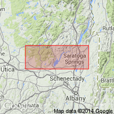
Reports give thicknessess of Little Falls dolomite of 74 to 124 feet in Hamilton County; 160 to 200 in Broadalbin quadrangle (Fulton and Saratoga Counties); and 300 to 400 at Saratoga Springs and vicinity; and of Hoyt limestone as 100+ and 120 feet in Saratoga County, and 300+ feet in Dutchess County, where according to E.B. Knopf (1927, Amer. Jour. Sci., 5th ser., v. 14, p. 429-458) it consists of arenaceous limestone and dolomite carrying Hoyt fauna, overlain by Rochdale limestone and disconformably underlain by Stissing dolomite.
Source: US geologic names lexicon (USGS Bull. 896, p. 1194-1196).
- Usage in publication:
-
- Little Falls dolomite*
- Modifications:
-
- Revised
- AAPG geologic province:
-
- New England province
Summary:
Pg. 412, 414. Assigned Little Falls dolomite to Upper Cambrian and placed it above Theresa formation and unconformably below Amsterdam limestone (Black River).
Source: US geologic names lexicon (USGS Bull. 896, p. 1194-1196).
- Usage in publication:
-
- Little Falls dolomite*
- Modifications:
-
- Revised
- AAPG geologic province:
-
- Appalachian basin
Summary:
Late studies show Little Falls dolomite (formerly included in Beekmantown) to be uppermost member of Lower Ozarkian series in New York and to be separated from overlying Tribes Hill limestone of Canadian system by unconformity. It overlies Hoyt limestone, which is a more calcareous and more fossiliferous phase of lower part of Little Falls dolomite. [On p. 233 she stated Hoyt is "basal phase" of Little Falls. In tables on p. 191 and 194 she assigned Little Falls dolomite to "Ozarkian (Saratogan) = Uppermost Cambrian of authors," and placed it above Hoyt limestone, which she excluded from Theresa. The USGS treats Hoyt as a member of Theresa formation.] She also stated: The Little Falls consists of light-gray to dark-gray crystalline or subcrystalline dolomite; black and gray cherts are found frequently at certain horizons, and certain layers are full of nodules of crystalline calcite; the summit is very apt to be formed of a massive CRYPTOZOON reef, often heavily silicified; maximum thickness of formation 200+/- feet; except for the CRYPTOZOON, fossils are very scarce.
Source: US geologic names lexicon (USGS Bull. 896, p. 1194-1196).
- Usage in publication:
-
- Little Falls dolomite*
- Modifications:
-
- Adopted
- AAPG geologic province:
-
- Adirondack uplift*
- New England province*
- Appalachian basin*
Summary:
In Jan. 1936 the USGS further restricted Little Falls dolomite to the lower (major) part of the beds included in it since 1910, as explained under Beekmantown group.
The USGS treats Hoyt limestone as a member of Theresa dolomite and classifies it and Little Falls dolomite restricted as Upper Cambrian.
Source: US geologic names lexicon (USGS Bull. 896, p. 1194-1196).
- Usage in publication:
-
- Little Falls dolomite*
- Modifications:
-
- Revised
- AAPG geologic province:
-
- Adirondack uplift
- New England province
Summary:
Pg. 1576. Discussion of upper Champlain Valley. Name Little Falls proposed by Clarke (1903) for pre-Tribes Hill Calciferous of Mohawk Valley. Ulrich and Cushing, 1911 (New York State Mus. Bull., no. 140) extended name into Champlain Valley to include all of division A and part of division B, of Brainerd and Seely [1891] (Amer. Mus. Nat. Hist. Bull., v. 3). There is a significant unconformity 35 feet below base of division B, and this break seems to correspond with break above the Little Falls in Mohawk Valley. Beds of division B together with upper 35 feet of division A are here named Whitehall formation.
Source: US geologic names lexicon (USGS Bull. 1200, p. 2188-2189).
- Usage in publication:
-
- Little Falls dolomite*
- Modifications:
-
- Revised
- AAPG geologic province:
-
- New England province
Summary:
Cambro-Ordovician correlations revised in Champlain, Hudson, Mohawk, and St. Lawrence Valleys. Revisions involve definitions and successions of previously accepted Cambro-Ordovician formations (Upper Cambrian Potsdam, Theresa, Hoyt, and Little Falls and Lower Ordovician Whitehall, Tribes Hill, and Beekmantown). "Typical" Theresa is physically and faunally differentiated from "Upper Theresa" (now Huevelton member of Tribes Hill formation); Hoyt fauna occurs in lower half of emended Whitehall formation above Little Falls dolomite; a new upper (Skene) member of Whitehall formation represents late Cambrian offlap; two marine cycles, represented by Tribes Hill formation (containing the Norton-Heuvelton, Fort Ann-Bucks Bridge, Benson-Ogdensburg members) and the Cassin formation, constitute the Beekmantown series. Oneota, Stonehenge, Van Buren, and Gasconade faunas occur in Tribes Hill formation, not in Little Falls as generally believed. Each revised unit is tied in with the divisions A through E of original "Calciferous" formation (Brainerd and Seely, [1891]).
Source: US geologic names lexicon (USGS Bull. 1200, p. 2188-2189).
- Usage in publication:
-
- Little Falls dolomite*
- Modifications:
-
- Revised
- AAPG geologic province:
-
- New England province
Summary:
Pg. 522-523. Base of Whitehall formation is raised to coincide with contact of Little Falls dolomite and Hoyt limestone, and latter is redefined as a lower member of Whitehall formation. In corrected Skene Mountain section, Little Falls formation, about 210 feet thick, overlies Theresa formation.
Source: US geologic names lexicon (USGS Bull. 1200, p. 2188-2189).
- Usage in publication:
-
- Little Falls dolomite
- Modifications:
-
- Revised
- AAPG geologic province:
-
- Appalachian basin
Summary:
Pg. 795-813. Evidence presented to substantiate radical change in interpretation of Paleozoic stratigraphy of Saratoga Springs region, New York. Previously accepted sequence of beds (Potsdam sandstone, Theresa formation, Hoyt limestone, Little Falls dolomite, Amsterdam limestone, Trenton limestone, Canajoharie shale) is revised to read Potsdam sandstone, Galway formation, Hoyt limestone, Ritchie limestone (new), Mosherville sandstone (new), Gailor dolomite (new), Lowville limestone, Amsterdam limestone, Trenton limestone (Rockland(?), Hull, Sherman Fall representatives) and Canajoharie shale. Term "Theresa" is not applicable in this area; hence, name Galway is reintroduced for strata younger than Potsdam and older than Hoyt. Lower Ordovician beds have been traced into Saratoga region from Mohawk Valley and constitute most of dolomite which has heretofore been regarded as Little Falls dolomite (Upper Cambrian). Wheeler was first to suggest that the long-accepted stratigraphy of region was not true one. He stated that Hoyt limestone overlay Little Falls dolomite in Saratoga region and that the dolomite which overlay the Hoyt was a younger formation to which he applied name Skene. He classified Hoyt limestone as basal member of the Whitehall and Skene as upper member, the latter being a very late Upper Cambrian offlapping unit. He mistook Ordovician Gailor dolomite for the older Little Falls dolomite, for the Hoyt and his supposed "Little Falls" are in fault contact in his "unfaulted" area 4 miles west of Saratoga Springs. Tracing of Little Falls dolomite from its type locality at Little Falls, eastward into Saratoga region shows that it is absent there as such, but that its correlatives are facies equivalents, namely, Potsdam sandstone, Galway formation, and perhaps even a part of Hoyt limestone. Little Falls dolomite (restricted) thus represents and offshore, more carbonate phase of the aforementioned formations. Absence of these formations within Mohawk Valley further corroborates this interpretation; wherever exposed, the Little Falls rests directly on the Precambrian.
Source: US geologic names lexicon (USGS Bull. 1200, p. 2188-2189).
- Usage in publication:
-
- Little Falls Dolostone*
- Modifications:
-
- Principal reference
- AAPG geologic province:
-
- Appalachian basin
Summary:
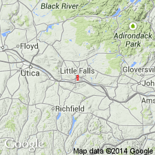
Composite type section designated here consists of six localities, illustrated on sketch map, and all within Little Falls 7.5-min quadrangle. Upper contact with Tribes Hill Formation exposed at Locs. 13 and 17. Basal nonconformable contact with Proterozoic gneiss exposed at Loc. 15.
Loc. 13 (W/2): upper 90 feet of unit exposed along south-flowing stream south of Little Falls Reservoir and east of Top Notch Road, in and above Buttermilk Falls.
Loc 14 (W/2): 205 feet of section, partly covered, along secondary road (leading to Burrell's Mansion) and along hillside north of road beginning at elevation of about 590 feet at northern end of Williams Street.
Loc. 15 (SW/4): base of unit exposed at top of south side of railroad cut just south of old Jefferson Street School, on south side of Mohawk River and Barge Canal; top of cut at about 400 feet.
Loc. 16 (SW/4): lower 65 feet of unit exposed in steep face just south of NY Route 167, 0.5 mile east of north-flowing tributary at loc. 17; base of measured section at about 410 feet elevation.
Loc. 17 (SW/4): 300 feet of section along northwest-flowing tributary of Mohawk River, directly southwest of steep bluff termed "Rollaway."; measured section begins at 420 feet elevation.
Loc. 18 (SW/4): 200 feet of middle Little falls exposed along another northwest-flowing tributary of Mohawk River, about 1.2 miles southwest of city hall and 0.5 mile west of Loc. 17; section begins just southeast of NY Route 167 at about 410 feet elevation.
Source: Modified from GNU records (USGS DDS-6; Reston GNULEX).
- Usage in publication:
-
- Little Falls Dolostone
- Modifications:
-
- Overview
- Dominant lithology:
-
- Dolostone
- Sandstone
- AAPG geologic province:
-
- Appalachian basin
Summary:
Unit is well known for its exceptionally clear, doubly terminated quartz crystals, known as "diamonds" and for the irregular masses of algal stromatolites, which occur at several levels, particularly in informal unit B. Brachiopods have been reported at several localities, but except for the stromatolites, the unit, for the most part, is unfossiliferous. Lithology is quite varied. Though dolostone is predominant, sandstone and mixed sandstone and dolostone beds are common. The mineralogy of the Little Falls is extremely varied. Unit includes quartz, calcite, dolomite, pyrite, marcasite, galena, sphalerite, limonite, chalcopyrite, hematite, glauconite, and anthraxolite. Inferred age of the quartz crystals is Carboniferous, while deposition of the limestone occurred during the Late Cambrian.
Source: GNU records (USGS DDS-6; Reston GNULEX).
For more information, please contact Nancy Stamm, Geologic Names Committee Secretary.
Asterisk (*) indicates published by U.S. Geological Survey authors.
"No current usage" (†) implies that a name has been abandoned or has fallen into disuse. Former usage and, if known, replacement name given in parentheses ( ).
Slash (/) indicates name conflicts with nomenclatural guidelines (CSN, 1933; ACSN, 1961, 1970; NACSN, 1983, 2005, 2021). May be explained within brackets ([ ]).