

- Usage in publication:
-
- Lincolnshire limestone member
- Modifications:
-
- Named
- Dominant lithology:
-
- Limestone
- AAPG geologic province:
-
- Appalachian basin
Summary:
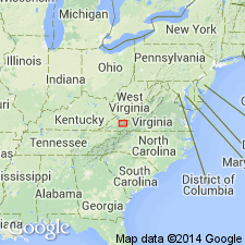
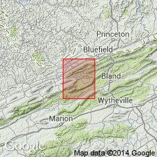
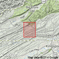
Named Lincolnshire limestone member of the Cliffield formation for a branch tributary of the Clinch River called Lincolnshire in Tazewell Co., VA. In Tazewell Co., the Chazyan and Black River groups of Butts (1940) are subdivided into 29 zones. The Lincolnshire limestone member of the Cliffield formation (zones 1-9) is proposed for zone 5, which consists of brownish-gray to black medium-grained irregularly bedded limestone averaging 60 feet thick (thickness at type locality is 102 feet). The Lincolnshire limestone member overlies the Five Oaks limestone member and underlies the Ward Cove limestone member, both of the Cliffield formation. The Lincolnshire is of Middle Ordovician age.
Source: GNU records (USGS DDS-6; Reston GNULEX).
- Usage in publication:
-
- Lincolnshire limestone
- Modifications:
-
- Revised
- AAPG geologic province:
-
- Appalachian basin
Summary:
The Lincolnshire is raised to formation rank as the Lincolnshire limestone of the Cliffield group in the valley between Brushy and Walker Mountains. The Lincolnshire is the Leonir of Butts in belts southwest of Clinch Mountain but not the same as the Lenoir identified by Butts in some areas north of Clinch Mountain.
Source: GNU records (USGS DDS-6; Reston GNULEX).
- Usage in publication:
-
- Lincolnshire limestone
- Modifications:
-
- Areal extent
- AAPG geologic province:
-
- Appalachian basin
Summary:
The Lincolnshire limestone is geographically extended to northeastern TN.
Source: GNU records (USGS DDS-6; Reston GNULEX).
- Usage in publication:
-
- Lincolnshire formation
- Modifications:
-
- Revised
- AAPG geologic province:
-
- Appalachian basin
Summary:
Named the Eidson member of the Lincolnshire formation for Eidson, Hawkins Co., northeastern TN. Member is thin part of Lincolnshire that underlies the Hogskin shale. Consists of dark limestone containing black chert. Unit is present in Clinch, Hogskin, and Beaver Valleys. The Eidson is of Middle Ordovician age. Also named the Hogskin member of the Lincolnshire formation in Grainger Co., northeastern TN. Derivation of name not stated but name is credited to B.N. Cooper. Consists of yellow-weathering shale and cobbly limestone, both of "Ottosee type" and usually confused with that formation. Member overlies Eidson member of the Lincolnshire and underlies the Ward Cove or Rockdell formations. The Hogskin is of Middle Ordovician age.
Source: GNU records (USGS DDS-6; Reston GNULEX).
- Usage in publication:
-
- Lincolnshire limestone*
- Modifications:
-
- Overview
- AAPG geologic province:
-
- Appalachian basin
Summary:
The Lincolnshire limestone of Middle Ordovician age is adopted for use by the U.S. Geological Survey for that part of the Duffield quadrangle southeast of the Clinchport fault. Unit is 45 feet thick and consists of dark-gray arenite-textured limestone with abundant olive-black chert nodules and wavy partings spaced 1 inch apart.
Source: GNU records (USGS DDS-6; Reston GNULEX).
- Usage in publication:
-
- Lincolnshire Formation
- Modifications:
-
- Revised
- AAPG geologic province:
-
- Appalachian basin
Summary:
On the Geologic map of Virginia, the Lincolnshire is revised as the Lincolnshire Formation.
Source: GNU records (USGS DDS-6; Reston GNULEX).
- Usage in publication:
-
- Lincolnshire Formation
- Modifications:
-
- Revised
- AAPG geologic province:
-
- Appalachian basin
Summary:
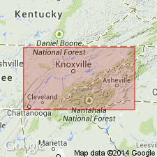
The Lincolnshire Formation is considered one of nine formations in the Chickamauga Group in northeastern TN. Consists of thick-bedded, light gray to pink, medium- to coarse-grained limestone of constant 100 meter thickness. Unit thins to southeast where it grades into Lenoir Formation. The Lincolnshire overlies the Five Oaks Formation and underlies the Rockdell Formation, both of the Chickamauga Group.
Source: GNU records (USGS DDS-6; Reston GNULEX).
- Usage in publication:
-
- Lincolnshire Limestone*
- Modifications:
-
- Areal extent
- AAPG geologic province:
-
- Appalachian basin
Summary:
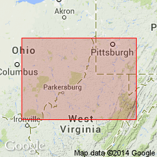
In cross-section E-E', extended into WV subsurface, in Pendleton Co. drillhole. In vicinity of Harrisonburg, VA, the Lincolnshire is not a member of Black River Group but is its equivalent.
Source: GNU records (USGS DDS-6; Reston GNULEX).
For more information, please contact Nancy Stamm, Geologic Names Committee Secretary.
Asterisk (*) indicates published by U.S. Geological Survey authors.
"No current usage" (†) implies that a name has been abandoned or has fallen into disuse. Former usage and, if known, replacement name given in parentheses ( ).
Slash (/) indicates name conflicts with nomenclatural guidelines (CSN, 1933; ACSN, 1961, 1970; NACSN, 1983, 2005, 2021). May be explained within brackets ([ ]).