

- Usage in publication:
-
- Garita Creek Formation
- Modifications:
-
- Named
- Dominant lithology:
-
- Sandstone
- Mudstone
- Conglomerate
- AAPG geologic province:
-
- Palo Duro basin
Summary:
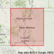
Name newly applied to some rocks in the Tucumcari basin of NM formerly assigned to the lower shale member of the Chinle Formation. Named for Garita Creek, an intermittent tributary of Conchas Lake, northern San Miguel Co, NM in the Palo Duro basin. Type section is along and south of La Garita Creek about 0.25 km southwest of State Hwy 105 in sec 4 [or 10?], T12N, R24E. Extensively exposed in drainage of Conchas River and its tributaries south and west of Conchas Lake. Is 71 m thick at its type measured section where it conformably overlies Tres Lagunas Member of Santa Rosa Formation and disconformably underlies Trujillo Formation. Basal contact red brown, very calcareous mudstone (Garita Creek) on gray quartzose, micaceous, fine- to medium-grained sandstone (Tres Lagunas). Consists mostly of mudstone (gray red to red brown, mottled gray green, calcareous, limestone nodules). Massive, laminar fine-grained gray red sandstone makes up 25 percent of the formation. Thin intraformational conglomerates found at base of channel-sandstone make up 2 percent of the formation. Has maximum thickness of 122-152 m. Present in parts of San Miguel and Guadalupe Cos. Nomenclature chart. Vertebrate fossils of Carnian age. Columnar section.
Source: GNU records (USGS DDS-6; Denver GNULEX).
- Usage in publication:
-
- Garita Creek Formation
- Modifications:
-
- Areal extent
- AAPG geologic province:
-
- Palo Duro basin
- Las Vegas-Raton basin
Summary:
The mudstone between the Santa Rosa (below) and the Trujillo (above) Formations from Montezuma Creek in San Miguel Co, NM in the Palo Duro basin to Uracca Creek, Colfax Co, NM in the Las Vegas-Raton basin, is assigned to the Garita Creek Formation. The formation ranges from 7.8 to 26 m thick; it forms soil and vegetation covered strike valleys. Identified in measured sections at Montezuma Gap and San Sebastian Canyon, San Miguel Co, Palo Duro basin, and north into Mora Co at La Cueva and Colfax Co at Rayado and Uracca Creeks, Las Vegas-Raton basin. Cross sections. Nomenclature chart. Overlies Tres Lagunas Member of Santa Rosa Formation. Underlies Trujillo Formation. Of Late Triassic, Carnian age in this report.
Source: GNU records (USGS DDS-6; Denver GNULEX).
For more information, please contact Nancy Stamm, Geologic Names Committee Secretary.
Asterisk (*) indicates published by U.S. Geological Survey authors.
"No current usage" (†) implies that a name has been abandoned or has fallen into disuse. Former usage and, if known, replacement name given in parentheses ( ).
Slash (/) indicates name conflicts with nomenclatural guidelines (CSN, 1933; ACSN, 1961, 1970; NACSN, 1983, 2005, 2021). May be explained within brackets ([ ]).