


- Usage in publication:
-
- Elgin sandstone*
- Modifications:
-
- Original reference
- Dominant lithology:
-
- Sandstone
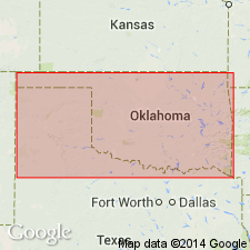
- AAPG geologic province:
-
- Cherokee basin
Summary:
Pg. 64. Name suggested by G.I. Adams. Elgin sandstone. Sandstones, within Lecompton shales in southern part of State, which have great development around Elgin. Age is Pennsylvanian. [Lecompton shales of early Kansas reports has been replaced by Kanwaka shale.]
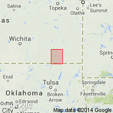
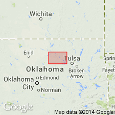
[Elgin is in Chautauqua Co., southern KS, just north of KS-OK line.]
Source: US geologic names lexicon (USGS Bull. 896, p. 667-668).
- Usage in publication:
-
- Elgin sandstone*
- Modifications:
-
- Areal extent
- AAPG geologic province:
-
- Cherokee basin
Summary:
Elgin sandstone. Hard ferruginous sandstone that weathers rough. Thickness 10 feet in this quadrangle. Rests conformably on Oread limestone. Age is Pennsylvanian.
Source: US geologic names lexicon (USGS Bull. 896, p. 667-668).
- Usage in publication:
-
- Elgin sandstone*
- Modifications:
-
- Areal extent
- AAPG geologic province:
-
- Chautauqua platform
Summary:
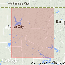
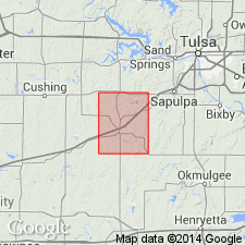
Pg. 12-13. Elgin sandstone. Is 50 to 40 feet thick. It crops out in eastern part of Osage County, Oklahoma, and extends across Osage and Pawnee Counties. Rests on Oread limestone and is overlain by 700 feet of Pennsylvanian shales with thin limestones. Age is Pennsylvanian.
Source: US geologic names lexicon (USGS Bull. 896, p. 667-668).
- Usage in publication:
-
- Elgin sandstone*
- Modifications:
-
- Areal extent
- AAPG geologic province:
-
- Cherokee basin
- Chautauqua platform
Summary:
Pg. 44-49. Elgin sandstone. Is 50 to 140 feet thick. Is 140 feet thick near Elgin, Kansas, where it consists of an upper and lower sandstone member separated by shaly sandstone. Rests on Oread limestone. [Age is Pennsylvanian.]
Source: US geologic names lexicon (USGS Bull. 896, p. 667-668).
- Usage in publication:
-
- Elgin sandstone*
- Modifications:
-
- Areal extent
- AAPG geologic province:
-
- Cherokee basin
- Chautauqua platform
Summary:
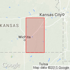
In northern Kansas the Kanwaka shale is calcareous and locally includes thin beds of impure limestone, but to south it becomes very sandy and may well be called a sandstone. The name Elgin sandstone has been suggested by Haworth (1898) for this phase, on account of expousres near Elgin, Chautauqua County, where it is nearly 140 feet thick, but to south it becomes thinner. Age is Pennsylvanian.
Source: US geologic names lexicon (USGS Bull. 896, p. 667-668).
- Usage in publication:
-
- Elgin sandstone*
- Modifications:
-
- Areal extent
- AAPG geologic province:
-
- Chautauqua platform
Summary:
Pg. 12. Elgin sandstone has been traced across Pawhuska and Hominy, Oklahoma, quadrangles by C.D. Smith and R.H. Wood, to whose unpublished maps writer has had access. In Bristow quadrangle, Oklahoma, it is a friable gray to yellowish brown sandstone 50 to 80+/- feet thick. Is exposed near western margin of quadrangle and is highest sandstone of considerable thickness in stratigraphic section. In west-central part of quadrangle it is differentiated with difficulty from underlying Bristow formation. Its upper surface is distinct across the quadrangle and is a good stratigraphic boundary. It is separated from overlying Permian beds by several hundred feet of Pennsylvanian shale, sandstone, and limestone. Age is Pennsylvanian.
Source: US geologic names lexicon (USGS Bull. 896, p. 667-668).
- Usage in publication:
-
- Elgin sandstone*
- Modifications:
-
- Areal extent
- AAPG geologic province:
-
- Chautauqua platform
Summary:
Pg. 75, 77. Elgin sandstone is a massive sandstone, consisting usually of but a single member, but it is more shaly to north. Thickness 50 to 210 feet. It rests on Nelagoney formation. Age is Pennsylvanian.
Source: US geologic names lexicon (USGS Bull. 896, p. 667-668).
- Usage in publication:
-
- Elgin sandstone*
- Modifications:
-
- Areal extent
- AAPG geologic province:
-
- Chautauqua platform
Summary:
Elgin sandstone underlies Pawhuska formation and overlies Nelagoney formation across central northern and part of central Oklahoma. Age is Pennsylvanian.
Source: US geologic names lexicon (USGS Bull. 896, p. 667-668).

- Usage in publication:
-
- Elgin sandstone*
- Modifications:
-
- Overview
- AAPG geologic province:
-
- Cherokee basin
Summary:
Pg. 67. In southern Kansas, much of the interval between the Lecompton and Oread formations is occupied by sandstone, sandy shale, and red shale collectively called Elgin sandstone. Age is Late Pennsylvanian (Virgilian).
Source: US geologic names lexicon (USGS Bull. 1200, p. 1228-1229).
- Usage in publication:
-
- Elgin sandstone member*
- Modifications:
-
- Revised
- Mapped 1:500k
- AAPG geologic province:
-
- Chautauqua platform
Summary:
Mapped as Elgin sandstone member of Vamoosa formation. Age is Late Pennsylvanian (Virgilian).
Source: US geologic names lexicon (USGS Bull. 1200, p. 1228-1229).
- Usage in publication:
-
- Elgin sandstone member*
- Modifications:
-
- Areal extent
- AAPG geologic province:
-
- Chautauqua platform
Summary:
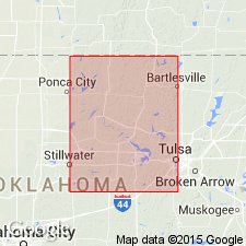
Pg. 32-34. Elgin sandstone member of Vamoosa formation. Elgin in Pawnee County, Oklahoma, consists of four sandstone beds and numerous sandstone lenses within Kanwaka shale member of Vamoosa. Age is Pennsylvanian (Virgilian).
Source: US geologic names lexicon (USGS Bull. 1200, p. 1228-1229).

- Usage in publication:
-
- Elgin sandstone
- Modifications:
-
- Revised
- AAPG geologic province:
-
- Cherokee basin
Summary:
(Paleozoic Era; Pennsylvanian System by J.M Jewett, H.G. O'Connor, and D.E. Zeller, p. 36.) Follows Moore and others (1951) definition, but considers Elgin sandstone an informal (or local) unit below member rank.
Source: Publication.
For more information, please contact Nancy Stamm, Geologic Names Committee Secretary.
Asterisk (*) indicates published by U.S. Geological Survey authors.
"No current usage" (†) implies that a name has been abandoned or has fallen into disuse. Former usage and, if known, replacement name given in parentheses ( ).
Slash (/) indicates name conflicts with nomenclatural guidelines (CSN, 1933; ACSN, 1961, 1970; NACSN, 1983, 2005, 2021). May be explained within brackets ([ ]).