

- Usage in publication:
-
- Chester amphibolite member
- Modifications:
-
- Revised
- AAPG geologic province:
-
- New England province
Summary:
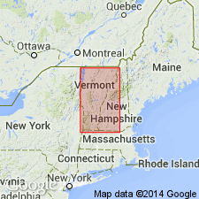
Revised to the Chester amphibolite member of the Pinney Hollow formation in southern and central VT. Consists of thin-layered, ligniform amphibolite and hornblende schist and includes actinolitic greenstone and greenstone north of Windham. Unit is of Early Cambrian age.
Source: GNU records (USGS DDS-6; Reston GNULEX).
- Usage in publication:
-
- Chester Amphibolite Member*
- Modifications:
-
- Revised
- Age modified
- Areal extent
- AAPG geologic province:
-
- New England province
Summary:
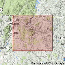
Rowe Schist revised in northwestern MA to include all strata between top of Hoosac Schist and bottom of Moretown Formation. Mapping has shown that amphibolite mapped by Emerson (1898) as one continuous unit is actually a series of beds distributed over a considerable stratigraphic interval; similar strata occur above and below Emerson's Chester Amphibolite, making upper contact of Rowe tenuous and usefulness of Chester as a formation doubtful. In addition, mapping has shown that upper part of Savoy Schist of MA is equivalent to Moretown Formation of VT; lower part of Savoy correlates with Stowe and Ottauquechee Formations in VT. This new mapping allows revision of Rowe Schist to include all of Emerson's original Rowe plus his Chester Amphibolite, and lower schistose part of his Savoy Schist. It also includes MA equivalents of Pinney Hollow Formation and its Chester Amphibolite Member, and Ottauquechee and Stowe Formations of VT. Chester Amphibolite Member is retained as a member of Rowe but only for proven continuations of amphibolite from VT to its type locality in Chester, MA. Includes rocks ranging in age from Early to Late Cambrian and possibly Early Ordovician. [Fig. 5 shows definite range of Rowe Schist into Early Ordovician, but amphibolite remains in Cambrian section.]
Source: GNU records (USGS DDS-6; Reston GNULEX).

- Usage in publication:
-
- Chester Amphibolite Member*
- Modifications:
-
- Overview
- AAPG geologic province:
-
- New England province
Summary:
Rowe Schist of Cambrian and Early Ordovician age. Informal amphibolite-rich member includes Chester Amphibolite Member at its type locality in Chester, MA. Age of Chester not specified.
Source: GNU records (USGS DDS-6; Reston GNULEX).
For more information, please contact Nancy Stamm, Geologic Names Committee Secretary.
Asterisk (*) indicates published by U.S. Geological Survey authors.
"No current usage" (†) implies that a name has been abandoned or has fallen into disuse. Former usage and, if known, replacement name given in parentheses ( ).
Slash (/) indicates name conflicts with nomenclatural guidelines (CSN, 1933; ACSN, 1961, 1970; NACSN, 1983, 2005, 2021). May be explained within brackets ([ ]).