


- Usage in publication:
-
- Breckenridge limestone member
- Modifications:
-
- Original reference
- Dominant lithology:
-
- Limestone
- AAPG geologic province:
-
- Bend arch
Summary:
Pg. 152, 154, 155, 160; Jour. Geol., v. 30, no. 1, p. 24, 31, 1922. Breckenridge limestone member of Thrifty formation of Cisco group. Gray, massive, and resistant limestone, 3 to 5 feet thick, forming top member of Thrifty formation. Makes prominent escarpment in and about town of Breckenridge, Stephens County, and is typically exposed south of Main Street. Lies 25 to 45 feet above Blach Ranch limestone member of Thrifty, the two limestones being separated by shale. [Age is Pennsylvanian.]
Named from Breckenridge, Stephens Co., Brazos River region, central northern TX.
Source: US geologic names lexicon (USGS Bull. 896, p. 258).
- Usage in publication:
-
- Breckenridge limestone member
- Modifications:
-
- Areal extent
- AAPG geologic province:
-
- Bend arch
- Llano uplift
Summary:
Pg. 197+. Used Breckenridge limestone for top member of Thrifty formation in Colorado River region.
Source: US geologic names lexicon (USGS Bull. 896, p. 258).

- Usage in publication:
-
- Breckenridge limestone member
- Modifications:
-
- Not used
Summary:
The U.S. Geological Survey at present [ca. 1938] treats Chaffin limestone as top member of Thrifty formation in Colorado River region. Some geologists regard Chaffin limestone as = Breckenridge limestone.
Source: US geologic names lexicon (USGS Bull. 896, p. 258).
- Usage in publication:
-
- Breckenridge limestone member
- Modifications:
-
- Areal extent
- Dominant lithology:
-
- Limestone
Summary:
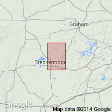
Pg. 54, 61. [Breckenridge limestone member], upper part of Thrifty formation, in Brazos River area, contains serveral beds of limestone, including Ivan and Blach Ranch members and, at top, Breckenridge limestone member. Thickness of Breckenridge varies from 5 feet near Crystal Falls to 1.5 feet near McCann Bridge. Underlies Harpersville formation.
Source: US geologic names lexicon (USGS Bull. 1200, p. 464-466).

- Usage in publication:
-
- Breckenridge formation
- Modifications:
-
- Revised
Summary:
Pg. 66 (fig. 1), 91. Breckenridge formation of Thrifty group. Rank raised. Underlies Chaffin formation; overlies Speck Mountain formation.
Source: US geologic names lexicon (USGS Bull. 1200, p. 464-466).
- Usage in publication:
-
- Breckenridge limestone member*
- Modifications:
-
- Biostratigraphic dating
- AAPG geologic province:
-
- Bend arch
Summary:
Breckenridge limestone member of Thrifty formation of Cisco group. Consists of several beds of limestone separated by shale, which at some places, is calcareous. Thickness about 5 to 9+ feet. Separated from underlying Speck Mountain member by 22 to 34 feet of shale with minor amounts of sandstone, and from overlying Chaffin limestone member by 30 to 50 feet of shale with minor amounts of sandstone. Fusulinid fauna is dominated by TRITICITES PLUMMERI Dunbar and Condra, 1927. Age is Late Pennsylvanian.
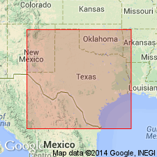
Recognized in Coleman, Brown, Eastland, and Stephens Cos., central TX.
Source: Publication; US geologic names lexicon (USGS Bull. 1200, p. 464-466).
- Usage in publication:
-
- Breckenridge limestone member
- Modifications:
-
- Principal reference
- Dominant lithology:
-
- Limestone
- AAPG geologic province:
-
- Bend arch
Summary:
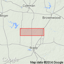
Pg. 7 (fig. 2), 8 (fig. 3), 18-20, pls. 1, 2. Breckenridge limestone member of Thrifty formation. Plummer (1919) applied name "Breckenridge formation" to a section containing three persistent limestone beds and one local limestone, thick shale beds, and lenticular sandstones above his "Gunsight" limestone. The three limestone beds which "form escarpments around east end of Breckenridge oil field" (idem) are the Breckenridge, Blach Ranch, and Ivan limestones of Plummer and Moore's [1922] classification. Breckenridge limestone member was defined by Plummer and Moore as upper limestone of Thrifty formation. It was described as gray, massive, and resistant, from 3 to 4 feet thick, and lying 25 to 45 feet above Blach Ranch member. Plummer and Moore did not include measured section of Breckenridge limestone in its type area, and nearest sections to it were measured at type Blach Ranch area, 10.5 miles northeast of Breckenridge and "in escarpment 2 miles northeast of Harpersville" (idem. p. 156), about 8 or 9 miles south of Breckenridge. Line labeled "Breckenridge limestone" on Plummer and Moore's plate 1 is not outcrop of Breckenridge limestone according to their type description but is the outcrop of Blach Ranch limestone. Bradish (1937, Geologic map of Brown County) and Plummer and others (1949, Texas Univ. Bur. Econ. Geol. Pub. 4915, pl. 4) traced outcrop of type Breckenridge limestone in type area and Lee (1938) traced Breckenridge limestone in northern Stephens County. Mapping for present report shows that the limestone which Plummer and Moore labeled "Breckenridge" in each of their measured sections in Stephens and Young Counties correlates with their type Breckenridge. Hence, the inconsistency between type description of Breckenridge limestone and outcrop map is interpreted as mislabeling and not an error in type description. Type reference section herein described. Breckenridge outcrop is prominent escarpment throughout most of area. The resistant massive mottled bed of Breckenridge member that caps this escarpment and many outliers is of uniform lithology and thickness. This limestone bed averages 1.8 feet and weathers into angular fragments, usually mottled gray to orange or reddish brown. About 1 foot of nodular or irregularly bedded limestone occurs above and below the massive mottled bed except near Breckenridge, where these limestone units thicken to 3 or 4 feet. Overlies unnamed shale member; underlies Quinn clay member of Harpersville formation.
Type reference section: on Harris Veale property, near south city limits of Breckenridge, west of US Hwy 183, Stephens Co., Brazos River region, central northern TX. Lower part of section measured from base of Blach Ranch limestone at road level on west side US Hwy 183 westward to pond excavated in Breckenridge limestone at top of prominent escarpment (fig. 5, beds 1A-5A). Upper part of section offset westward along outcrop of massive mottled bed of Breckenridge (fig. 5, bed 5A); upper interval measured from base of bioclastic limestone bed of Breckenridge, exposed in gully 1, northwest 20 yards, then southwest to sandstone above Crystal Falls limestone at top of isolated hill (fig. 5, beds 5B-12). All three units of Breckenridge (beds 5A, B, and C) are partly exposed in gullies 2 and 3, beds 5B and 5C are best exposed in gully 1. Makes prominent escarpment in and about town of Breckenridge, Stephens Co., Brazos River region, central northern TX.
Source: US geologic names lexicon (USGS Bull. 1200, p. 464-466).
- Usage in publication:
-
- Breckenridge limestone member*
- Modifications:
-
- Areal extent
- Dominant lithology:
-
- Limestone
- AAPG geologic province:
-
- Bend arch
Summary:
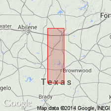
Pg. 72-73, pl. 27. Breckenridge limestone member of Thrifty formation. Named by Plummer and Moore [1922] for a gray massive resistant limestone, 3 or 4 feet thick, forming prominent escarpment in and about Breckenridge in Stephens County. They considered it easily traceable to northeast and south and possibly identifiable with upper Chaffin bed of Drake (1893) in Colorado River valley. Bullard and Cuyler (Univ. Texas Bull. 3501, 1935) followed Plummer and Moore's correlations, and the bed they mapped as Breckenridge through northern McCulloch County is the Chaffin limestone of Drake (1893). Cheney and Eargle (1951, Geologic map of Brown County) mapped the Breckenridge and showed it in the interval between their Chaffin and Speck Mountain limestones. Breckenridge was mapped for present report as far southwest as Home Creek and was found to be correlative with the bed Drake considered the lower Chaffin limestone. From vicinity of Home Creek southwest to Colorado River in southeastern Coleman County, this limestone and shale immediately above and below it is removed by channel erosion and channel filled by Parks Mountain sandstone member. Breckenridge not recognized south of Colorado River. Breckenridge is 20 to 40 feet above Speck Mountain limestone member. Beds that intervene between Breckenridge and Chaffin members in Brown County and north of Home Creek in eastern Coleman County are red clay. Plummer and Bradley (1949) named this Quinn clay for exposures in Eastland County.
Source: US geologic names lexicon (USGS Bull. 1200, p. 464-466).

- Usage in publication:
-
- Breckenridge Limestone
- Modifications:
-
- Revised
- Mapped
- AAPG geologic province:
-
- Fort Worth syncline
- Bend arch
Summary:
Breckenridge Limestone [unranked]. Up to 3 beds of gray to yellowish-brown, fine-grained, thin- to irregularly bedded limestone interstratified with thin, gray to pale-green shale. Thickness 1 to 3.5 feet. Defines base of Markley Formation of Bowie Group, except along southern border of quadrangle where it defines base of partly equivalent Harpersville Formation of Cisco Group. Overlies Thrifty and Graham Formations (undivided) of Cisco Group. Occurs below Crystal Falls Limestone [unranked] in Harpersville. Earlier workers included these rocks at top of Thrifty Formation. Sparsely fossiliferous. Age is Late Pennsylvanian (Virgil).
Forms slight escarpment to low bench in Young and Jack Cos., northern central TX; northern termination northeast of Graham, near Jermyn, in western Jack Co.
Source: Publication.
For more information, please contact Nancy Stamm, Geologic Names Committee Secretary.
Asterisk (*) indicates published by U.S. Geological Survey authors.
"No current usage" (†) implies that a name has been abandoned or has fallen into disuse. Former usage and, if known, replacement name given in parentheses ( ).
Slash (/) indicates name conflicts with nomenclatural guidelines (CSN, 1933; ACSN, 1961, 1970; NACSN, 1983, 2005, 2021). May be explained within brackets ([ ]).