

- Usage in publication:
-
- Blackwater Draw Formation
- Modifications:
-
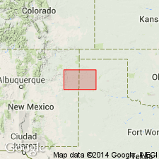
- Areal extent
- Overview
- AAPG geologic province:
-
- Palo Duro basin
Summary:
Is Pleistocene formation mapped in Deaf Smith and northwestern Randall Cos, TX (Palo Duro basin), TX panhandle. Previously mapped as windblown cover sand. Map unit described as sand, fine- to medium-grained quartz, silty, calcareous, locally clayey, caliche nodules, massive, grayish-red; distinct surface soil profile and buried paleosols; thickness as much as 90 ft in northwestern Randall Co, feathers out locally. Assigned to Pleistocene (mostly Illinoian).
Source: GNU records (USGS DDS-6; Denver GNULEX).

- Usage in publication:
-
- Blackwater Draw Formation
- Modifications:
-
- Mapped 1:250k
- Dominant lithology:
-
- Sand
- AAPG geologic province:
-
- Permian basin
Summary:
Blackwater Draw Formation. Sand, fine- to medium-grained quartz, silty, calcareous, caliche nodules, massive, grayish-red. Distinct soil profile. Thickness 25 feet; feathers out locally. Age is Pleistocene (mostly Illinoian, may include younger deposits).
[Mapped in western half of sheet, in Crosby, Dickens, Floyd, Garza, Hale, Lubbock, Lynn, and Motley Cos., TX.]
Source: Publication.
For more information, please contact Nancy Stamm, Geologic Names Committee Secretary.
Asterisk (*) indicates published by U.S. Geological Survey authors.
"No current usage" (†) implies that a name has been abandoned or has fallen into disuse. Former usage and, if known, replacement name given in parentheses ( ).
Slash (/) indicates name conflicts with nomenclatural guidelines (CSN, 1933; ACSN, 1961, 1970; NACSN, 1983, 2005, 2021). May be explained within brackets ([ ]).