

- Usage in publication:
-
- Bigelow Brook Formation*
- Modifications:
-
- Named
- Dominant lithology:
-
- Schist
- Gneiss
- AAPG geologic province:
-
- New England province
Summary:
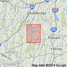
Bigelow Brook Formation of Brimfield Group here named in northeastern CT and adjacent MA. Composite type section designated. Lower and middle members in lower section northeast of Black Pond fault along line from point on Crystal Brook Pond trending N. 29 deg. W. to where unpaved road crosses quad. border in Eastford quad, Windham Co., CT. Middle and upper members in upper section along line from intersection of North Ashford Road and unnamed road trending N. 54 deg. W. to point northwest of Lead Mine Brook and south of Susstek Road in Westford quad., Windham Co., CT. Unit described as brown to gray schist and banded gneiss. Thickness greater than 5200 m. Underlies Hamilton Reservoir Formation, also of Brimfield Group. In fault contact with Southbridge Formation on northwest. Age uncertain. Currently interpreted as Ordovician(?) to Silurian(?).
Source: GNU records (USGS DDS-6; Reston GNULEX).
- Usage in publication:
-
- Bigelow Brook Member*
- Modifications:
-
- Revised
- Age modified
- AAPG geologic province:
-
- New England province
Summary:
Paxton Formation divided into (ascending): Bigelow Brook Member (now reduced in rank from Bigelow Brook Formation, removed from Brimfield Group, and reassigned to Paxton) and Southbridge Member (now reduced in rank from Southbridge Formation). Age of Paxton and Southbridge changed from Ordovician or older to probably Silurian; age of Bigelow Brook changed from Ordovician(?) to Early Devonian(?) to probable Silurian. Bigelow Brook and Southbridge Formations remain good usage in northeastern CT. Paxton Formation remains good usage in south-central NH where it is not subdivided formally.
Source: GNU records (USGS DDS-6; Reston GNULEX).

- Usage in publication:
-
- Bigelow Brook Member*
- Modifications:
-
- Overview
- AAPG geologic province:
-
- New England province
Summary:
Used as Bigelow Brook Member of Paxton Formation of Silurian age.
Source: GNU records (USGS DDS-6; Reston GNULEX).
- Usage in publication:
-
- Bigelow Brook Formation*
- Modifications:
-
- Age modified
- AAPG geologic province:
-
- New England province
Summary:
The age of the Brimfield Group and its Bigelow Brook, Hamilton Reservoir, and Mount Pisgah Formations in this area is considered to be Cambrian(?) based on the intrusion of 440 m.y. Hedgehog Hill gneiss emplaced near the top of the Hamilton Reservoir Formation in the upper part of the Brimfield, although the top of the Brimfield, at least, may be Ordovician or older Paleozoic.
Source: GNU records (USGS DDS-6; Reston GNULEX).
For more information, please contact Nancy Stamm, Geologic Names Committee Secretary.
Asterisk (*) indicates published by U.S. Geological Survey authors.
"No current usage" (†) implies that a name has been abandoned or has fallen into disuse. Former usage and, if known, replacement name given in parentheses ( ).
Slash (/) indicates name conflicts with nomenclatural guidelines (CSN, 1933; ACSN, 1961, 1970; NACSN, 1983, 2005, 2021). May be explained within brackets ([ ]).