

- Usage in publication:
-
- Bell Ranch formation*
- Modifications:
-
- Original reference
- Dominant lithology:
-
- Sandstone
- Siltstone
- AAPG geologic province:
-
- Palo Duro basin
Summary:
Pg. 2006, fig. 2. Bell Ranch formation of San Rafael group. Alternating sequence of light-gray sandstone and brownish-red siltstone beds. The alternating, parallel beds are 2 to 10 feet thick, in sharp contrast to massive Entrada sandstone below and poorly bedded Morrison formation above. Small nodules of gypsum present in uppermost bed of siltstone in northeastern part of area, and in vicinity of Colorado line, thin beds of gypsum found within beds of siltstone. Thickness 66 feet at type locality; ranges from 0 to about 65 feet in the area. Formerly called Wanakah formation in this area. Age is Late Jurassic.
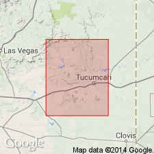
Type section: at Carpenter's Point, 18 mi southeast of Bell Ranch headquarters and 13 mi northwest of Tucumcari, [San Miguel Co.], northeastern NM. Named from Bell Ranch and proposed that name be used in Tucumcari-Sabinoso area and in northeastern NM.
Source: US geologic names lexicon (USGS Bull. 1200, p. 291).
- Usage in publication:
-
- Bell Ranch Formation
- Modifications:
-
- Revised
- Reference
- Dominant lithology:
-
- Siltstone
- Sandstone
- AAPG geologic province:
-
- Sierra Grande uplift
- Palo Duro basin
Summary:
Revised in that Bell Ranch Formation overlies Entrada Sandstone (formerly called Exeter Sandstone) in east-central NM in the Sierra Grande uplift and Palo Duro basin. Reference section designated at Punta de Gallegos [not located on map in text] where Bell Ranch is composed of siltstone and gypsiferous sandstone. Distinguished from underlying Entrada by its laterally continuous bedding, red color, lack of large-scale crossbeds, and poorer sorting. Interfingers with Exeter Member (reduced in rank and restricted to upper part of former Exeter). Underlies Morrison Formation unconformably. Varies from 0 to about 20 m in thickness. May be a regressive facies of the Todilto. Probably late Callovian, Middle Jurassic age. Of lacustrine origin. Correlation chart. Columnar section.
Source: GNU records (USGS DDS-6; Denver GNULEX).
- Usage in publication:
-
- Bell Ranch Formation*
- Modifications:
-
- Areal extent
- AAPG geologic province:
-
- Las Vegas-Raton basin
- Sierra Grande uplift
Summary:
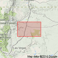
Mapped along the Canadian River from T24N, R23E, Colfax Co, NM in Las Vegas-Raton basin to T21N, R24E on the Mora-Harding Co line, on the Sierra Grande uplift. Averages 50 ft thick in map area. Overlies Exeter Sandstone (not Entrada Sandstone) and underlies Morrison Formation. Assigned a Middle Jurassic age. Name used in map area [which is northwest of its type at Bell Ranch] in preference to Wanakah Formation, a southwest CO and northwest NM name, because the stratigraphic meaning of Bell Ranch-Wanakah correlation is not well understood.
Source: GNU records (USGS DDS-6; Denver GNULEX).
For more information, please contact Nancy Stamm, Geologic Names Committee Secretary.
Asterisk (*) indicates published by U.S. Geological Survey authors.
"No current usage" (†) implies that a name has been abandoned or has fallen into disuse. Former usage and, if known, replacement name given in parentheses ( ).
Slash (/) indicates name conflicts with nomenclatural guidelines (CSN, 1933; ACSN, 1961, 1970; NACSN, 1983, 2005, 2021). May be explained within brackets ([ ]).