

- Usage in publication:
-
- Alligator Back Formation*
- Modifications:
-
- Original reference
- Dominant lithology:
-
- Gneiss
- Schist
- Amphibolite
- AAPG geologic province:
-
- Piedmont-Blue Ridge province
Summary:
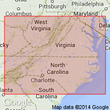
Pg. 17-19. Alligator Back Formation. Gneiss with interlayered schist and amphibolite. Conformably overlies Ashe Formation. Intruded by Spruce Pine plutonic group. Recognized in northwestern North Carolina and southwestern Virginia. Age is Precambrian Y and (or) early Paleozoic.
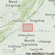
Type locality: exposures on Bluff Mountain (Alligator Back), Lat. 36 deg. 25 min. 02 sec. N., Long. 81 deg. 11 min. 02 sec. W., Whitehead quadrangle, Alleghany Co., northwestern NC.
Source: US geologic names lexicon (USGS Bull. 1520, p. 8); supplemental information from GNU records (USGS DDS-6; Reston GNULEX).
- Usage in publication:
-
- Alligator Back Formation*
- Modifications:
-
- Revised
- Areal extent
- AAPG geologic province:
-
- Piedmont-Blue Ridge province
Summary:
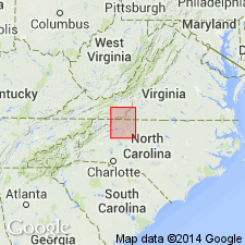
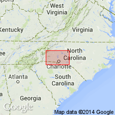
Occurs in northeast-southwest-trending belt along Blue Ridge in Carroll, Floyd, Franklin, and Patrick Cos., north-central NC, and in Allegheny, Surry, and Wilkes Cos., south-central VA. Equals laminated gneiss and schist unit of companion map I-709-A by Rankin and others (1972). Units abg = pg, aba = pa, and abs = ps of Map I-709-A. Main part of unit typically consists of finely laminated gneiss composed of quartzo-feldspathic layers a few millimeters thick separated by very thin micaceous partings; rock has pinstripe appearance. Thicker schist or phyllite and amphibolite or greenstone layers are common. Some massive gneiss layers and micaceous granule conglomerate present. Gneiss is generally more micaceous than similar units in Ashe Formation. Calcsilicate lenses locally abundant. Several parts of Alligator Back separately mapped. Unit abs consists of mica schist and phyllite typically containing garnet and magnetite, interlayered with minor biotite-muscovite gneiss and amphibolite. Unit aba consists of amphibolite, garnet amphibolite, and greenstone interlayered with biotite-muscovite gneiss and metapelite. Unit abm consists of layered impure marble and calc-schist. Age is Precambrian and (or) Paleozoic.
Source: GNU records (USGS DDS-6; Reston GNULEX).

- Usage in publication:
-
- Alligator Back Formation
- Modifications:
-
- Age modified
- Geochronologic dating
- AAPG geologic province:
-
- Piedmont-Blue Ridge province
Summary:
Pegmatites from the area around Spruce Pine, NC, similar to the type intruding Alligator Back, yield an age of 350 m.y. (Lesure, 1968); therefore, minimum age of Alligator Back could be implied. Authors date gneiss and schist samples of Alligator Back using Rb-Sr methods with the following results. Location 1, sample 906 (Alligator Back Formation in Wilkes Co., NC) and its biotite separate, yields an age of 317 m.y. Location 4, sample 1156, (Alligator Back Formation in Carroll Co., VA) is a gneiss which yields a biotite-whole rock age of 329 m.y. Biotite from location 3, sample 518 (Ashe Formation of Carroll Co., VA) yields a mineral whole rock age of 337 m.y. Of note is that stratigraphically younger Alligator Back Formation does not yield significantly younger whole rock ages than Ashe Formation.
Source: GNU records (USGS DDS-6; Reston GNULEX).
- Usage in publication:
-
- Alligator Back Formation*
- Modifications:
-
- Age modified
- AAPG geologic province:
-
- Piedmont-Blue Ridge province
Summary:
Age changed from Precambrian and (or) Paleozoic to Proterozoic Z and (or) Paleozoic based on its position overlying Ashe Formation and in accordance with accepted subdivisions of the Precambrian.
Source: GNU records (USGS DDS-6; Reston GNULEX).
- Usage in publication:
-
- Alligator Back Formation
- Modifications:
-
- Mapped
- AAPG geologic province:
-
- Piedmont-Blue Ridge province
Summary:
Alligator Back Formation subdivided into three unnamed units: mica schist and phyllite, gneiss, and amphibolite. Age is Late Proterozoic.
Source: GNU records (USGS DDS-6; Reston GNULEX).
- Usage in publication:
-
- Alligator Back Formation
- Modifications:
-
- Revised
- Dominant lithology:
-
- Marble
- AAPG geologic province:
-
- Piedmont-Blue Ridge province
Summary:
In this report, Lynchburg Group consists of typical Lynchburg, Ashe, and Alligator Back Formations. Alligator Back applied to interlayered schist-gneiss sequence containing mafic and ultramafic rocks, graphite schists, and marble that forms top of Lynchburg.
Source: GNU records (USGS DDS-6; Reston GNULEX).
- Usage in publication:
-
- Alligator Back Formation*
- Modifications:
-
- Areal extent
- Age modified
- AAPG geologic province:
-
- Piedmont-Blue Ridge province
Summary:
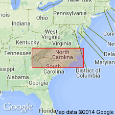
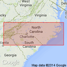
Mapped in narrow belt in Caldwell Co., central NC, in Blue Ridge belt. Age refined to Late Proterozoic and (or) early Paleozoic. Consists of laminated quartzofeldspathic gneiss with thin micaceous partings and local thick lenses of phyllite, schist, and amphibolite; also includes mica schist and phyllite containing garnet and magnetite interlayered with subordinate biotite-muscovite gneiss and amphibolite.
Source: GNU records (USGS DDS-6; Reston GNULEX).
- Usage in publication:
-
- Alligator Back Metamorphic Suite
- Modifications:
-
- Revised
- Age modified
- AAPG geologic province:
-
- Piedmont-Blue Ridge province
Summary:
Because of its lithologic heterogeneity and metamorphic character, unit is here renamed Alligator Back Metamorphic Suite. Part of Toe terrane (of Raymond, 1987), which also includes Ashe Metamorphic Suite, Coweeta Group, and Tallulah Falls Metamorphic Suite. Age given as Late Proterozoic.
Source: GNU records (USGS DDS-6; Reston GNULEX).

- Usage in publication:
-
- Alligator Back Formation
- Modifications:
-
- Revised
- AAPG geologic province:
-
- Piedmont-Blue Ridge province
Summary:
Alligator Back Formation is mapped as part of the Lynchburg Group. It is divided into three unnamed lithologic map units: actinolite schist, banded marble, and feldspathic metagraywacke. The actinolite schist in the Lynchburg quad. was previously mapped as part of the Catoctin Formation or the Slippery Creek Greenstone by Brown (1958). The banded marble includes the Arch Marble of Brown (1958) and the Archer Creek Formation of Espenshade (1954). Metagraywacke units here mapped as Alligator Back Formation were previously mapped as Mount Athos Formation and Pelier Schist of the Evington Group and considered to be younger than the Lynchburg Group. However, recent mapping by Henika (1991) indicates that rocks assigned to Alligator Back by Rankin and others (1973) are continuous with the upper part of the Lynchburg in the type section along the James River. They dip southeast beneath the overlying Candler Formation from the VA-NC border to the Lynchburg. Rock units immediately southeast of the Candler Formation in an outcrop belt from Stapleton on the James River, southwest to Leesville Dam on the Roanoke River, are older than the Candler and although previously mapped as upper Evington Group, these rocks are herein correlated with the Alligator Back Formation of the Lynchburg Group. Rocks southeast of the Bowens Creek fault, originally mapped as Evington are also assigned to the Alligator Back. Age of the Alligator Back is shown here as Late Proterozoic and Cambrian.
Source: GNU records (USGS DDS-6; Reston GNULEX).
For more information, please contact Nancy Stamm, Geologic Names Committee Secretary.
Asterisk (*) indicates published by U.S. Geological Survey authors.
"No current usage" (†) implies that a name has been abandoned or has fallen into disuse. Former usage and, if known, replacement name given in parentheses ( ).
Slash (/) indicates name conflicts with nomenclatural guidelines (CSN, 1933; ACSN, 1961, 1970; NACSN, 1983, 2005, 2021). May be explained within brackets ([ ]).