The National Geologic Map Database is migrating to a new infrastructure. We apologize for any service disruptions during this process.
|
|---|


- Usage in publication:
-
- Ammonoosuc volcanics
- Modifications:
-
- Original reference
- Dominant lithology:
-
- Schist
- AAPG geologic province:
-
- New England province
Summary:
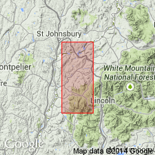
Ammonoosuc volcanics. Chlorite and sericite schists, of volcanic origin, 2,500 feet thick, underlying Partridge slate and overlying Albee quartzite in Littleton and Moosilauke quadrangles, Ammonoosuc River region, northwestern New Hampshire. No fossils, but are pre-Silurian (Late Ordovician?).
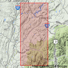
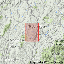
Named from old Ammonoosuc mining district of Hitchcock (1878) [a 100+ sq mi area situated northwest of Ammonoosuc River (btw. Woodsville and Littleton), south of Moore Reservoir, and east-southeast of Connecticut River, covering parts of Littleton, St. Johnsbury, Woodsville, and Moosilauke 15-min quadrangles, Grafton Co., northern NH].
Source: US geologic names lexicon (USGS Bull. 896, p. 47).
- Usage in publication:
-
- Ammonoosuc volcanics
- Modifications:
-
- Mapped
- AAPG geologic province:
-
- New England province
Summary:
Pg. 13-15. Ammonoosuc volcanics. Marland P. Billings mapped the rocks of parts of Littleton and Moosilauke quadrangles, and his map shows Ammonoosuc River flowing through his Ammonoosuc volcanics at and around Littleton and to southward. [Age is pre-Silurian (Late Ordovician?).] The name replaces what he called "Swiftwater-Lyman formation" in February 1933 issue of Amer. Jour. Sci., according to letter dated July 19, 1935.
Source: US geologic names lexicon (USGS Bull. 896, p. 47).
- Usage in publication:
-
- Ammonoosuc volcanics
- Modifications:
-
- Principal reference
- AAPG geologic province:
-
- New England province
Summary:
Pg. 10, 20. Ammonoosuc volcanics. Type locality in district bounded on north by Slate Ledge School and Partridge Lake and on south by Youngs Pond (Ogontz Lake) and Tinkerville, New Hampshire. The formation is also well exposed along Ammonoosuc River but with a different metamorphic character. Most of material would be classified as tuff, breccia, or volcanic conglomerate, and was largely deposited by streams flowing westward from active volcanoes to east. It includes a number of rock types which grade into one another. Believed to be Late Ordovician.
Source: US geologic names lexicon (USGS Bull. 896, p. 47).
- Usage in publication:
-
- Ammonoosuc volcanics*
- Modifications:
-
- Mapped
- Dominant lithology:
-
- Gneiss
- Schist
- AAPG geologic province:
-
- New England province
Summary:
Ammonoosuc volcanics. Geographically extended into Franklin and Worcester Counties, central northern Massachusetts, where it underlies Clough formation. Rocks previously included in Dana diorite by Emerson, 1915 (USGS Bull. 597). Consists of (separately mapped): mostly fine-grained, light-gray or white quartz-feldspar gneiss, containing small amounts of layered quartz-feldspar-diopside granulite; lesser hornblende gneiss and schist; and tentatively, a narrow belt of quartz-mica-sillimanite schist, similar to parts of Littleton formation. Rocks are weakly to moderately foliated and generally not stratified. West of Warwick fault maximum thickness perhaps 2,500 feet; east of fault only upper part [800+/- feet] of formation exposed. Age is Ordovician; oldest rocks exposed in quadrangle.
Source: Publication; US geologic names lexicon (USGS Bull. 1200, p. 81-82).

- Usage in publication:
-
- Ammonoosuc volcanics
- Modifications:
-
- Areal extent
- AAPG geologic province:
-
- New England province
Summary:
Pg. 7 (fig. 3), 17-19, 94-98, geol. map. Ammonoosuc volcanics. Present in four zones, chiefly in western part of state. Belt that extends northeast from Woodsville includes type locality. Second belt northeast of Monroe correlated with Ammonoosuc volcanics because of its lithology and stratigraphic position above Albee formation. Third belt, extending northeast from 3 miles east of Haverhill, correlated because of its lithology and repetition of entire stratigraphic sequence from Albee to Littleton. Fourth belt extending whole length of the state, correlated because of its lithology and repetition of stratigraphic sequence, from Ammonoosuc formation through Littleton. In area southwest of Littleton, where both top and bottom of formation are present. Ammonoosuc volcanics are about 2,000 feet thick, but extensive folding makes precise determination difficult. In belt that extends north from Massachusetts to Maine, formation is thinner because only top is exposed above Oliverian plutonic series. Four miles southwest of Randolph thickness is about 5,000 feet. Summary of arguments for and against correlations with other units. Age is considered Late Ordovician(?) on geologic map, but formation may be Middle Ordovician.
Source: US geologic names lexicon (USGS Bull. 1200, p. 81-82).
- Usage in publication:
-
- Ammonoosuc volcanics
- Modifications:
-
- Areal extent
- AAPG geologic province:
-
- New England province
Summary:
Pg. 544-545, 551, 554, pl. 1. Ammonoosuc volcanics. Discussion of stratigraphic and geotectonic relationships in northern Vermont and southern Quebec. Ammonoosuc volcanics assigned to Middle Ordovician.
Source: US geologic names lexicon (USGS Bull. 1200, p. 81-82).

- Usage in publication:
-
- Ammonoosuc Volcanics*
- Modifications:
-
- Overview
- AAPG geologic province:
-
- New England province
Summary:
Used as Ammonoosuc Volcanics of Middle Ordovician age. Main unit consists of amphibolite, felsic gneiss, garnet-amphibole quartzite, and marble, all too thin to map separately. Hornblendite (ultramafic rock) and a basal quartzite and conglomerate separately mapped.
Source: GNU records (USGS DDS-6; Reston GNULEX).
- Usage in publication:
-
- Ammonoosuc Volcanics*
- Modifications:
-
- Revised
- Areal extent
- AAPG geologic province:
-
- New England province
Summary:
Bronson Hill autochthonous sequence, separated from Piermont allochthon by Foster Hill sole fault, consists of the mainly basaltic facies of the lower member of Ammonoosuc Volcanics (Middle Ordovician), Partridge Formation (Middle Ordovician), Clough Quartzite (Lower Silurian), Fitch Formation (Upper Silurian), and Littleton Formation (Lower Devonian). Rocks assigned to upper member of Ammonoosuc Volcanics and Quimby Formation in previous publications (Moench and others, 1987; Moench, 1989) are now assigned to lower member of Ammonoosuc and Partridge. Changes are based on mapping done in 1989 on Sunday Mountain (fig. 2 of report) where lower basaltic Ammonoosuc is overlain by black schist of the Partridge, which is in turn overlain by felsic and mixed metavolcanics of upper Ammonoosuc. About 15 km northeast of fig. 2 area, upper member of Ammonoosuc is overlain by black sulfidic schist and metagraywacke of Quimby Formation (which differs only in minor ways from Partridge). About 60 km northeast of fig. 2 area, Ammonoosuc is underlain by interbedded schist and quartzite of Upper Cambrian(?) and Lower Ordovician Dead River Formation, which is remarkably similar to Perry Mountain Formation of Piermont allochthon. Previous reports (mentioned above) incorrectly assign rocks to Dead River Formation that actually belong to Perry Mountain. Report includes geologic map and correlation chart.
Source: GNU records (USGS DDS-6; Reston GNULEX).
- Usage in publication:
-
- Ammonoosuc Volcanics
- Modifications:
-
- Age modified
- Geochronologic dating
- AAPG geologic province:
-
- New England province
Summary:
U-Pb zircon ages suggest that the Ammonoosuc Volcanics and tuffs of the Partridge Formation were erupted 453 to 449 Ma meaning they are of late Middle Ordovician and earliest Late Ordovician age. The stratigraphic relationships of these two units is very complex with current thought being that the Partridge lies between the lower and upper members of the Ammonoosuc Volcanics.
Source: GNU records (USGS DDS-6; Reston GNULEX).

- Usage in publication:
-
- Ammonoosuc Volcanics*
- Modifications:
-
- Revised
- Age modified
- Geochronologic dating
- Areal extent
- AAPG geologic province:
-
- New England province
Summary:
Geographically extended into western ME. Divided into seven, mostly intergradational facies. Basaltic facies in Cupsuptic, Oquossoc, and Rangeley, ME, 15-min quads was previously mapped as part of Dixville Formation by Harwood (1973) and Guidotti (1977), and as unnamed mafic volcanic rocks by Moench and Pankiwskyj (1988). In Milan, NH, and Old Speck Mountain, ME, 15-min quads, was previously mapped as Middle Ordovician mixed volcanic rocks by Moench and Pankiwskyj (1988). Sedimentary and basaltic facies in Littleton and Whitefield, NH, 15-min quads was previously mapped as Albee Formation by Billings (1956) and later as Dead River Formation by Moench and others (1987). Other subdivisions include felsic volcanic facies, proximal bimodal volcanic facies, volcaniclastic graywacke facies, silicate iron-formation and quartz-gneiss, and pyritic alteration facies. Ordovician (Whiterockian and Mohawkian) age is based on 1) early Mohawkian graptolites (Harwood and Berry, 1967) found in black slate of Partridge Formation, which intertongues with basaltic facies of Ammonoosuc in Cupsuptic, ME, 15-min quad; 2) early Mohawkian or late Whiterockian U-Pb zircon age of 461 +/-8 Ma obtained from felsic metatuff (J.N. Aleinikoff, this report); 3) Whiterockian age of 467 +/-3 Ma obtained from Chickwolnepy intrusions (interpreted to be comagmatic with early Ammonoosuc eruptions) (Aleinikoff and Moench, 1992); and 4) Whiterockian age of 469 +/-1.3 Ma obtained from tonalite of Joslin Turn pluton, (also considered to be comagmatic with early Ammonoosuc eruptions) (Aleinikoff and Moench, 1992). Author uses time scale of Ross and others (1982, modified by Ross, 1992, written commun.).
Source: GNU records (USGS DDS-6; Reston GNULEX).

- Usage in publication:
-
- Ammonoosuc Volcanics*
- Modifications:
-
- Geochronologic dating
- Age modified
- AAPG geologic province:
-
- New England province
Summary:
Used as Middle and Late Ordovician Ammonoosuc Volcanics. Mapped as nine informal subdivisions, including bimodal volcanic rocks and metasedimentary rocks within upper part of Ammonoosuc, and metavolcanic and metasedimetary rocks (undivided), metabasalt, bimodal volcanic rocks, volcaniclastic metagraywacke, metasedimentary rocks, felsic metavolcanic rocks, and white quartz-kyanite rock and silicate iron formation within lower part of Ammonoosuc. Middle and Late Ordovician Partridge Formation lies stratigraphically between upper and lower parts of the Ammonoosuc. Upper part of Ammonoosuc is probably equivalent to Partridge Formation in MA. Middle and Late Ordovician age is based on isotopic age of 444 +/-4 Ma by U/Pb methods from Ammonoosuc at Bath, NH (J.N. Aleinikoff, oral commun., 1991), and 461 +/-8 Ma by U/Pb methods (J.N. Aleinikoff, oral commun., 1994). Report includes geologic map, cross sections, correlation chart, and four 1:500,000-scale derivative maps.
Source: GNU records (USGS DDS-6; Reston GNULEX).
- Usage in publication:
-
- Ammonoosuc Volcanics of Billings (1935)*
- Modifications:
-
- Mapped
- Dominant lithology:
-
- Tuff
- Tuff breccia
- AAPG geologic province:
-
- New England province
Summary:
Ammonoosuc Volcanics of Billings (1935). Divided into, and separately mapped: (1) greenish- and bluish-gray metarhyolite tuff, lapilli tuff, tuff breccia, and lava, strongly foliated with waxy sheen on foliation surfaces; (2) greenish- to bluish-gray metamorphosed andesitic and basaltic tuff, crystal tuff, and tuff breccia, contains minor pillow lava; (3) coarsely porphyritic greenish- and bluish-gray metarhyolite tuff, lapilli tuff, and tuff breccia; (4) metamorphosed aphyric rhyolite tuff; (5) bluish-, greenish-, and dark-gray metasiltstone and phyllite, and medium-gray feldspathic metawacke, purple tinge common; (6) siliceous and argillaceous dolomite and calcareous pelite; and (7) dark-gray to grayish-black, rusty-weathering sulfidic slate and phyllite interlayered with felsic tuffs, locally forms base of Ammonoosuc Volcanics. Where Ammonoosuc undivided, consists of heterogeneous interlayered and interfingering metamorphosed volcanic, volcaniclastic, and sedimentary rocks; compositions range from basalt to sodic rhyolite; fragmental rocks dominate (tuff to tuff breccia). Age is Middle to Late Ordovician.
Notable exposures in Bronson Hill arch and Sawyer Mountain belt.
Source: Publication.
- Usage in publication:
-
- Ammonoosuc Volcanics
- Modifications:
-
- Mapped
- Age modified
- AAPG geologic province:
-
- New England province
Summary:
Ammonoosuc Volcanics. Dominantly metamorphosed rhyolite tuff, lapilli tuff, tuff breccia, and rhyolite, strongly foliated with waxy sheen on foliation surfaces. Approximate age of lower part 480 to 462 Ma (Early to Middle Ordovician), upper part 458 to 445 Ma (Late Ordovician); citing Aleinikoff and others, 2015, GSA Abs. w/ Prog., v. 47, no. 3, p. 41.
Source: Publication.
For more information, please contact Nancy Stamm, Geologic Names Committee Secretary.
Asterisk (*) indicates published by U.S. Geological Survey authors.
"No current usage" (†) implies that a name has been abandoned or has fallen into disuse. Former usage and, if known, replacement name given in parentheses ( ).
Slash (/) indicates name conflicts with nomenclatural guidelines (CSN, 1933; ACSN, 1961, 1970; NACSN, 1983, 2005, 2021). May be explained within brackets ([ ]).