

- Usage in publication:
-
- Hanna formation
- Modifications:
-
- Original reference
- Dominant lithology:
-
- Shale
- Sandstone
- Conglomerate
- Coal
- AAPG geologic province:
-
- Green River basin
Summary:
Pg. 228, 231, etc. Hanna formation. Alternating beds of shale, sandstone, conglomerate, and numerous coal beds. The shale is dark-gray, yellowish and carbonaceous; the sandstones are white, gray and brown, massive to thin-bedded and cross-bedded; the conglomeratic sandstones contain pebbles of chert, granite, quartzite, sandstone, Mowry shale, Cloverly conglomerate, etc. Contains fossil leaves. Thickness 7,000+/- feet. Unconformably underlies North Park formation and unconformably overlies Ferris formation. Is well exposed to west and north of town of Hanna, Carbon County. Is upper part of "Upper Laramie" of Veatch, the lower part of that unit being Ferris formation of this report. Age is Eocene.
Source: US geologic names lexicon (USGS Bull. 896, p. 906).
- Usage in publication:
-
- Hanna Formation*
- Modifications:
-
- Areal extent
- AAPG geologic province:
-
- Green River basin
Summary:
Areally restricted from Laramie and Carbon basins of the Greater Green River basin, southern and western WY. Outcrops of Hanna (as shown on WY State Geologic Map, 1954) cannot be traced nor are the thicknesses compatible from the Hanna basin into the Laramie and Carbon basins. Names Foote Creek and Dutton Creek Formations (new units) replace Hanna.
Source: GNU records (USGS DDS-6; Denver GNULEX).

- Usage in publication:
-
- Hanna Formation*
- Modifications:
-
- Overview
- AAPG geologic province:
-
- Green River basin
Summary:
No type locality or type section described in earlier reports. Studied only in the Hanna and Carbon basins of the Greater Green River basin for this report. Is of continental origin. Consists of conglomerate, sandstone, shale, and coal, thought to be as much as 13,500 ft thick. The conglomerate has pebbles of chert, quartzite, sandstone, Mowry Shale, Cloverly Formation. Conformably overlies Ferris Formation. Has plant microfossil, invertebrate and vertebrate fossils that indicate a late Paleocene age. Could be as old as late early Paleocene or middle Paleocene.
Source: GNU records (USGS DDS-6; Denver GNULEX).
- Usage in publication:
-
- Hanna Formation*
- Modifications:
-
- Biostratigraphic dating
- AAPG geologic province:
-
- Green River basin
Summary:
Pg. 53 (table 1). Hanna Formation. Palynomorphs (identified by D.J. Nichols, USGS) from the coal-bearing strata of the Hanna indicate a middle to late Paleocene age. Palynomorphs from Brooks Rider bed, near base of formation, indicate a middle Paleocene (zone P3) age. Higher beds yielded palynomorphs of late Paleocene age (probably zone P5, late but not latest Paleocene).
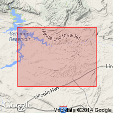
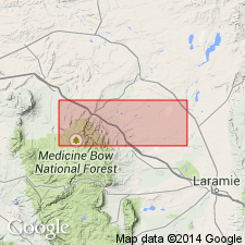
Study area in the Hanna basin, Carbon County, central southern Wyoming, where formation is up to 6,500 feet (1,981 m) thick.
For detailed descriptions of sampled intervals, see also G.B. Glass, 1975, Geol. Survey Wyoming Rpt. Inv., no. 11, 219 p., and G.B. Glass and J.T. Roberts, 1984, Geol. Survey Wyoming Rpt. Inv., no. 27, 104 p.
Source: Publication.
For more information, please contact Nancy Stamm, Geologic Names Committee Secretary.
Asterisk (*) indicates published by U.S. Geological Survey authors.
"No current usage" (†) implies that a name has been abandoned or has fallen into disuse. Former usage and, if known, replacement name given in parentheses ( ).
Slash (/) indicates name conflicts with nomenclatural guidelines (CSN, 1933; ACSN, 1961, 1970; NACSN, 1983, 2005, 2021). May be explained within brackets ([ ]).