


- Usage in publication:
-
- Reedsville shale*
- Modifications:
-
- Named
- Dominant lithology:
-
- Shale
- AAPG geologic province:
-
- Appalachian basin
Summary:
Named Reedsville shale for Reedsville, Mifflin Co., PA. Overlies Lower Trenton limestone and underlies the Oswego sandstone (Bald Eagle). Unit includes beds equivalent to Upper Trenton, Eden, and lower part of Maysville. Extends from central PA to southwestern VA. The Reedsville is of Late Ordovician age.
Source: GNU records (USGS DDS-6; Reston GNULEX).
- Usage in publication:
-
- Reedsville shale*
- Modifications:
-
- Overview
- AAPG geologic province:
-
- Appalachian basin
Summary:
In central PA the Reedsville shale consists of dark calcareous shale with thin layers of fossiliferous limestone; top 40 feet consists of thick-bedded calcareous sandstone containing ORTHORHYNCHULA and BYSSONICHIA (ORTHORHYNCHULA zone). Thickness is 1000 feet. Overlies the Trenton limestone and underlies the Oswego sandstone.
Source: GNU records (USGS DDS-6; Reston GNULEX).
- Usage in publication:
-
- Reedsville shale
- Modifications:
-
- Revised
- AAPG geologic province:
-
- Appalachian basin
Summary:
The Reedsville shale is revised to exclude about 400 feet of dark brownish weathering shale at the base of the unit. This shale is named the Antes shale.
Source: GNU records (USGS DDS-6; Reston GNULEX).
- Usage in publication:
-
- Reedsville shale
- Modifications:
-
- Areal extent
- AAPG geologic province:
-
- Appalachian basin
Summary:
Geographically extended the Reedsville shale to eastern TN where it is mapped east of Kingston fault. Thickness is 250 to 400 feet. Overlies unit 4 of Chickamauga limestone and underlies the Sequatchie formation. The Reedsville was called Athens shale by Hayes (USGS Geol. Atlas of the US, Kingston folio, no. 4, 1894; USGS Geol. Atlas of the US, Cleveland folio, no. 20, 1895) and Sevier shale by Keith (USGS Geol. Atlas of the US, Maynardville folio, no. 75, 1901).
Source: Modified from GNU records (USGS DDS-6; Reston GNULEX).
- Usage in publication:
-
- Reedsville Formation
- Modifications:
-
- Revised
- AAPG geologic province:
-
- Appalachian basin
Summary:
Revised the Reedsville to the Reedsville Formation. Consists of medium to dark gray, fissile shale at the base which grades into olive gray, thin-bedded shales, siltstones, and fine-grained sandstones which dominate in the upper part. The Reedsville is fossiliferous, especially in the upper part which contains the index fossil ORTHORHYNCHULA STEVENSONI. Thickness is 1500 feet. Both the upper and lower contact are gradational with the upper contact with the Bald Eagle Formation placed at the base of the first thick-bedded, resistant sandstone above the final occurrence of ORTHORHYNCHULA. Unit overlies the Salona Formation. The Reedsville is of Late Ordovician age.
Source: GNU records (USGS DDS-6; Reston GNULEX).
- Usage in publication:
-
- Reedsville Shale*
- Modifications:
-
- Revised
- AAPG geologic province:
-
- Appalachian basin
Summary:
Revised the Reedsville Shale to be included in the Chickamauga Group in TN. Unit is uppermost formation in group. Consists of pale olive gray shale with thin platy beds of calcareous siltstone and medium gray coquinoid limestone. Thickness is about 300 feet. Overlies the Trenton Limestone of the Chickamauga Group and underlies the Sequatchie Formation. The Reedsville is of Late Ordovician age.
Source: GNU records (USGS DDS-6; Reston GNULEX).
- Usage in publication:
-
- Reedsville Shale
- Modifications:
-
- Areal extent
- AAPG geologic province:
-
- Appalachian basin
Summary:
Geographically extended the Reedsville Shale to WV. Unit appears in stratigraphic column of figure 1. Overlies the Trenton Limestone and underlies the Oswego Sandstone. The Reedsville is equivalent to most of the Martinsburg Formation of previous WV county reports.
Source: GNU records (USGS DDS-6; Reston GNULEX).
- Usage in publication:
-
- Reedsville Formation
- Modifications:
-
- Geochronologic dating
- AAPG geologic province:
-
- Appalachian basin
Summary:
Isotopic dating of shale mylonite from the Reedsville Formation in PA reveals a K-Ar age of 372+/-8 Ma.
Source: GNU records (USGS DDS-6; Reston GNULEX).
- Usage in publication:
-
- Reedsville Formation
- Modifications:
-
- Overview
- AAPG geologic province:
-
- Appalachian basin
Summary:
The Reedsville Formation in eastern WV consists of dark shale that weathers to light yellow, tan, and red; sparsely fossiliferous and well developed cleavage. Thickness is 1500 to 2000 ft. Underlies the Oswego Sandstone and is equivalent to the Martinsburg Formation.
Source: GNU records (USGS DDS-6; Reston GNULEX).
- Usage in publication:
-
- Reedsville Formation
- Modifications:
-
- Overview
- AAPG geologic province:
-
- Appalachian basin
Summary:
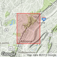
Reedsville has been traced throughout the Valley and Ridge province from central PA southwestward to western VA and eastern TN. Consists predominantly of medium-gray shale, which weathers to olive gray. Shale is quite fissile with no obvious bedding in lower part. Higher in the section, shale becomes slightly silty and unit becomes thin to medium bedded. At the top, siltstone constitutes more than 75 percent of the sequence. Only fossils found in study area are crinoid columnals. Gradationally overlies Antes Formation. Conformably underlies Bald Eagle Formation, where contact is placed at the base of the lowest sandstone. Thickness of 250+/-30 m calculated from dip and map-pattern width. Best exposure is along the Conrail tracks at the northeast end of Brush Mountain, in the Little Juniata River gap southeast of Tyrone, 2 km east of the eastern border of the Tipton quad. Elsewhere exposures are poor because of colluvial cover. Age is Late Ordovician.
Source: GNU records (USGS DDS-6; Reston GNULEX).
- Usage in publication:
-
- Reedsville Shale*
- Modifications:
-
- Revised
- Areal extent
- Age modified
- AAPG geologic province:
-
- Appalachian basin
Summary:
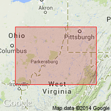
Extended from WV to subsurface of OH in cross section E-E'. Used for silty and calcareous gray shale located between Waverly arch in OH and Allegheny structural front in WV. Follows usage of Cardwell and others (1968; State map), Perry (1971, 1972), and Rader (1982). Differs from Reedsville Formation of Calvert (1964) in that his Reedsville included sediments now associated with Utica Shale of this report. Strata called Cincinnati Group by Wickstrom and Gray (1988) are here called Reedsville Shale. Correlates with Martinsburg Formation between North Mountain fault and Blue Ridge in VA. Age is Late Ordovician (approx. middle Edenian through Maysvillian) based on fossils. Conodont-based age of Shermanian through Maysvillian assigned by Diecchio (1985), and Diecchio and others (1985) is too old.
Source: GNU records (USGS DDS-6; Reston GNULEX).
For more information, please contact Nancy Stamm, Geologic Names Committee Secretary.
Asterisk (*) indicates published by U.S. Geological Survey authors.
"No current usage" (†) implies that a name has been abandoned or has fallen into disuse. Former usage and, if known, replacement name given in parentheses ( ).
Slash (/) indicates name conflicts with nomenclatural guidelines (CSN, 1933; ACSN, 1961, 1970; NACSN, 1983, 2005, 2021). May be explained within brackets ([ ]).