

- Usage in publication:
-
- Partridge slate
- Modifications:
-
- Original reference
- Dominant lithology:
-
- Slate
- AAPG geologic province:
-
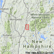
- New England province
Summary:
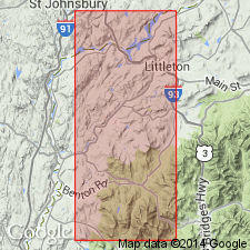
Partridge slate. Black slate, 0 to 2,000 feet thick, of pre-Silurian (Late Ordovician?) age. Unconformably underlies Clough conglomerate and overlies Ammonoosuc volcanics in Littleton and Moosilauke quadrangles, Ammonoosuc River region, northwestern New Hampshire. [Appears to replace what he called West Bath slate in his Feb. 1933 paper (Amer. Jour. Sci., 5th ser., v. 25, no. 146, p. 149).]
Source: US geologic names lexicon (USGS Bull. 896, p. 1607).

- Usage in publication:
-
- Partridge Formation*
- Modifications:
-
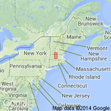
- Areal extent
- Overview
- AAPG geologic province:
-
- New England province
Summary:
Used as Partridge Formation of Middle Ordovician age. Includes rocks mapped as Brimfield Schist by Emerson (1917). Occurs in MA and along borders in CT and VT as shown on overlapping areas on map. Subdivided into 11 unnamed units. Also mapped as intimately interfolded with Lower Devonian Littleton Formation.
Source: GNU records (USGS DDS-6; Reston GNULEX).
- Usage in publication:
-
- Partridge Formation*
- Modifications:
-
- Revised
- AAPG geologic province:
-
- New England province
Summary:
Partridge Formation as mapped by Zen and others (1983) includes typical sulfidic mica schist and a variety of other lithic types, among them many but not all of the rocks formerly mapped in MA and CT as Brimfield Schist by Emerson (1898, 1917). Brimfield was raised to group rank by Peper and others (1975) to include Bigelow Brook, Hamilton Reservoir, and Mount Pisgah Formations. Bigelow Brook was removed from Brimfield Group and reassigned to Paxton Formation as Bigelow Brook Member by Goldsmith and others (1982). Brimfield Group not used by Zen and others (1983) on State Geologic Map because the unit can be shown to be a complex tectonic interlayering, by both folding and faulting, of a wide variety of Ordovician, Silurian, and Early Devonian rocks. Only a fraction of Brimfield Group was assigned to Partridge by Zen and others (1983); remainder was assigned to Silurian Paxton Formation and Lower Devonian Littleton Formation. In areas of poor exposure and incomplete mapping in northern Worcester Co., MA, Partridge is intimately interfolded with Littleton Formation and could not be shown separately by Zen and others (1983).
Source: GNU records (USGS DDS-6; Reston GNULEX).
- Usage in publication:
-
- Partridge Formation*
- Modifications:
-
- Revised
- Areal extent
- AAPG geologic province:
-
- New England province
Summary:
Footnotes [added to report just before it went to press] indicate that parts of the Littleton and Partridge Formations, and Clough Quartzite in MA are here assigned to the Rangeley Formation [here geographically extended to MA]. Littleton Formation rocks in the belt that enters MA from NH east of the Keene gneiss dome and extending to SW of Ware, and rocks in the Amherst inlet where Littleton and Partridge Formations are complexly interfolded, are here assigned to the Rangeley Formation. [These changes are not reflected on the MA State bedrock geologic map.] [Papers presented as chapters in U.S. Geological Survey Professional Paper 1366 are intended as explanations and (or) revisions to MA State bedrock geologic map of Zen and others (1983) at scale of 1:250,000.]
Source: GNU records (USGS DDS-6; Reston GNULEX).
- Usage in publication:
-
- Partridge Formation*
- Modifications:
-
- Revised
- Areal extent
- AAPG geologic province:
-
- New England province
Summary:
Bronson Hill autochthonous sequence, separated from Piermont allochthon by Foster Hill sole fault, consists of the mainly basaltic facies of the lower member of Ammonoosuc Volcanics (Middle Ordovician), Partridge Formation (Middle Ordovician), Clough Quartzite (Lower Silurian), Fitch Formation (Upper Silurian), and Littleton Formation (Lower Devonian). Rocks assigned to upper member of Ammonoosuc Volcanics and Quimby Formation in previous publications (Moench and others, 1987; Moench, 1989) are now assigned to lower member of Ammonoosuc and Partridge. Changes are based on mapping done in 1989 on Sunday Mountain (fig. 2 of report) where lower basaltic Ammonoosuc is overlain by black schist of the Partridge, which is in turn overlain by felsic and mixed metavolcanics of upper Ammonoosuc. About 15 km northeast of fig. 2 area, upper member of Ammonoosuc is overlain by black sulfidic schist and metagraywacke of Quimby Formation (which differs only in minor ways from Partridge). Report includes geologic map and correlation chart.
Source: GNU records (USGS DDS-6; Reston GNULEX).
- Usage in publication:
-
- Partridge Formation
- Modifications:
-
- Age modified
- Geochronologic dating
- AAPG geologic province:
-
- New England province
Summary:
U-Pb zircon ages suggest that the Ammonoosuc Volcanics and tuffs of the Partridge Formation were erupted between 453 to 449 Ma, meaning they are of late Middle Ordovician and earliest Late Ordovician age. The stratigraphic relationships of these two units is very complex with current thought being that the Partridge lies between the lower and upper members of the Ammonoosuc Volcanics.
Source: GNU records (USGS DDS-6; Reston GNULEX).

- Usage in publication:
-
- Partridge Formation*
- Modifications:
-
- Revised
- Areal extent
- Age modified
- Biostratigraphic dating
- AAPG geologic province:
-
- New England province
Summary:
Partridge Formation geographically extended into ME, in Bronson Hills-Boundary Mountains anticlinorium, in Rangeley, Cupsuptic, and Oquossoc 15-min quads where it was previously mapped as Dixville Formation by Harwood (1973) and Guidotti (1977) and as unnamed black slate by Moench and Pankiwskyj (1988). Green and Guidotti (1968) previously correlated these rocks with Partridge of Littleton and Moosilauke, NH, 15-min quads. Consists of black slate interbedded with quartzite and conglomerate. Includes lenses of basaltic greenstone too small to map as basaltic facies of Ammonoosuc Volcanics. In Old Speck Mountain, Me, 15-min quad, consists of schist interbedded with metagraywacke and amphibolite; intertongues with basaltic facies of lower part of Ammonoosuc. In Littleton and Moosilauke, NH, 15-min quads, consists of slate and schist, with local graded beds of metasiltstone and metagraywacke, thin beds of metatuff near upper contact, and intricately folded, white metachert near lower contact. Age changed to Ordovician (Whiterockian and Mohawkian) based on presence of early Mohawkian graptolite CLIMACOGRAPTUS BICORNIS (Harwood and Berry, 1967), and on Whiterockian and Mohawkian isotopic age data for intertonguing Ammonoosuc Volcanics (see Ammonoosuc GNULEX record); author uses time scale of Ross and others (1982, with modification by Ross, 1992, written commun.)
Source: GNU records (USGS DDS-6; Reston GNULEX).

- Usage in publication:
-
- Partridge Formation*
- Modifications:
-
- Overview
- Age modified
- AAPG geologic province:
-
- New England province
Summary:
Used as Middle to Late Ordovician Partridge Formation. Consists of black, rusty-weathering sulfidic-graphitic slate or schist, and sparse to abundant metagraywacke. Lies stratigraphically between upper and lower parts of Ammonoosuc Volcanics. Interstratified metavolcanics, chiefly amphibolites, within Partridge are separately mapped in southwestern NH. Age changed to Middle and Late Ordovician based on isotopic ages for Ammonoosuc Volcanics [see GNULEX record for Ammonoosuc]. Report includes geologic map, cross sections, correlation chart, and four 1:500,000-scale derivative maps.
Source: GNU records (USGS DDS-6; Reston GNULEX).
For more information, please contact Nancy Stamm, Geologic Names Committee Secretary.
Asterisk (*) indicates published by U.S. Geological Survey authors.
"No current usage" (†) implies that a name has been abandoned or has fallen into disuse. Former usage and, if known, replacement name given in parentheses ( ).
Slash (/) indicates name conflicts with nomenclatural guidelines (CSN, 1933; ACSN, 1961, 1970; NACSN, 1983, 2005, 2021). May be explained within brackets ([ ]).