The National Geologic Map Database is migrating to a new infrastructure. We apologize for any service disruptions during this process.
|
|---|


- Usage in publication:
-
- Leesburg Limestone Conglomerate Member*
- Modifications:
-
- Original reference
- Dominant lithology:
-
- Conglomerate
- Limestone
- Marble
- AAPG geologic province:
-
- Culpeper basin
Summary:
Pg. C6, pl. 1A, 1B. Leesburg Limestone Conglomerate Member of Bull Run Formation of Newark Group. Angular to subangular fragments of lower Paleozoic gray to blackish-gray, dark-gray, and pinkish-red limestone in a vein-quartz and clayey silt matrix, cemented by calcite. Is metamorphosed into a light-gray marble, called Potomac marble, where it is in contact with diabase in southeastern part of Leesburg, Virginia. Thickness 310 to 3,500 feet (190 to 1,070 m). Grades into and intertongues with the basaltic-flow-bearing clastics member of Bull Run Formation. Lower and middle part contains lenses of the underlying Balls Bluff Siltstone, also of Newark Group. Age is Late Triassic.
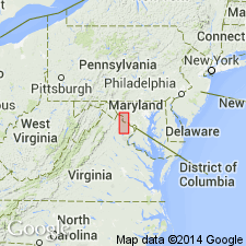
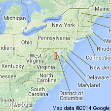
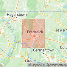
Type section: southeastern cuts at junction of U.S. Route 15 bypass and entrance road to Balls Bluff National Cemetery, Waterford quadrangle, Loudoun Co., northern VA. Named from exposures near Leesburg, Loudoun Co., northern VA. Extends northward into Frederick Co., MD.
[See also K.Y. Lee, 1979, USGS OFR-79-1557, 19 p., 16 pl. (geol. maps), scale 1:24,000.]
Source: Publication.
- Usage in publication:
-
- Leesburg Conglomerate Member
- Modifications:
-
- Revised
- AAPG geologic province:
-
- Culpeper basin
Summary:
The Leesburg is here renamed the Leesburg Conglomerate Member of the Bull Run Formation and is described as gray carbonate pebble conglomerate in a red sand-silt matrix. The pebbles are predominantly dolomite in the north and limestone in the south. The Leesburg is present from south of Leesburg northward across the Potomac River into Montgomery County, Maryland.
Source: GNU records (USGS DDS-6; Reston GNULEX).

- Usage in publication:
-
- Leesburg Member*
- Modifications:
-
- Revised
- AAPG geologic province:
-
- Culpeper basin
Summary:
The Leesburg is removed from the here abandoned Bull Run Formation and revised as the Leesburg Member of the Balls Bluff Siltstone, of which it forms the lenticular upper member in the northwestern part of the Culpeper basin. It interfingers extensively with the Balls Bluff and, to a lesser extent, with the lower part of the overlying Catharpin Creek Formation. Thickness ranges from a feather edge to 1,070 m (3,500 ft). Age is probably middle and late Norian.
Source: GNU records (USGS DDS-6; Reston GNULEX).
- Usage in publication:
-
- Leesburg Formation
- Modifications:
-
- Revised
- AAPG geologic province:
-
- Culpeper basin
For more information, please contact Nancy Stamm, Geologic Names Committee Secretary.
Asterisk (*) indicates published by U.S. Geological Survey authors.
"No current usage" (†) implies that a name has been abandoned or has fallen into disuse. Former usage and, if known, replacement name given in parentheses ( ).
Slash (/) indicates name conflicts with nomenclatural guidelines (CSN, 1933; ACSN, 1961, 1970; NACSN, 1983, 2005, 2021). May be explained within brackets ([ ]).