

- Usage in publication:
-
- Glenshaw Formation
- Modifications:
-
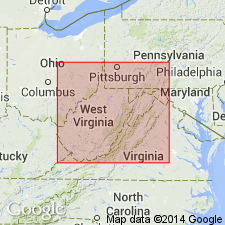
- Areal extent
- AAPG geologic province:
-
- Appalachian basin
Summary:
Geographically extended the Glenshaw Formation of the Conemaugh Group into WV. Consists of cyclic sequence of red and gray shale, siltstone, and sandstone with thin limestones and coals. The base of the Glenshaw is placed at the top of the Upper Freeport coal bed. Unit overlies the Allegheny Formation and underlies the Casselman Formation. The Glenshaw includes the Ames Limestone Member at the top.
Source: GNU records (USGS DDS-6; Reston GNULEX).
- Usage in publication:
-
- Glenshaw Formation*
- Modifications:
-
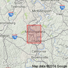
- Overview
- AAPG geologic province:
-
- Appalachian basin
Summary:
The Glenshaw Formation of the Conemaugh Group in the Monongahela quadrangle, southwestern PA, occurs only in the subsurface. Consists of limestone and calcareous shale that contain marine fossils. The Ames Limestone Member makes up the upper part of the formation. Unit underlies the Casselman Formation; no lower contact was observed. The Glenshaw is of Late Pennsylvanian age.
Source: GNU records (USGS DDS-6; Reston GNULEX).

- Usage in publication:
-
- Glenshaw Formation
- Modifications:
-
- Areal extent
- AAPG geologic province:
-
- Appalachian basin
Summary:
Glenshaw Formation is used for lower part of Conemaugh Group where Ames Limestone Member is present and forms top of formation. Extends down to top of Upper Freeport coal. Used only in PA and OH. Includes Mahoning Sandstone Member in both States.
Source: GNU records (USGS DDS-6; Reston GNULEX).
For more information, please contact Nancy Stamm, Geologic Names Committee Secretary.
Asterisk (*) indicates published by U.S. Geological Survey authors.
"No current usage" (†) implies that a name has been abandoned or has fallen into disuse. Former usage and, if known, replacement name given in parentheses ( ).
Slash (/) indicates name conflicts with nomenclatural guidelines (CSN, 1933; ACSN, 1961, 1970; NACSN, 1983, 2005, 2021). May be explained within brackets ([ ]).