

- Usage in publication:
-
- Hillier member
- Modifications:
-
- Original reference
- Dominant lithology:
-
- Limestone
- Shale
- AAPG geologic province:
-
- Appalachian basin
Summary:
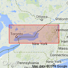
Pg. 280-281, pl. 4. Hillier member of Cobourg formation. Upper Cobourg limestone of earlier reports. Light-gray marly limestones in central Ontario and northern Michigan; darker colored limestone with shaly interbeds in New York and southeastern Ontario. Near the base, beds are argillaceous limestones in contrast to massive and resistant crystalline limestones at top of underlying Hallowell member (new); transition zone is 20 feet thick. Thickness 60 to 70 feet; thins rapidly in Lewis County, New York. Underlies Collingwood formation in central Ontario with transitional contact; disconformably underlies Deer River shales in northwestern New York.
Exposed for several mi along northern shore of Lake Ontario, west of Wellington, Hillier Twp., Prince Edward Co., Ontario, Canada. Named from the township.
Source: US geologic names lexicon (USGS Bull. 1200, p. 1763).
For more information, please contact Nancy Stamm, Geologic Names Committee Secretary.
Asterisk (*) indicates published by U.S. Geological Survey authors.
"No current usage" (†) implies that a name has been abandoned or has fallen into disuse. Former usage and, if known, replacement name given in parentheses ( ).
Slash (/) indicates name conflicts with nomenclatural guidelines (CSN, 1933; ACSN, 1961, 1970; NACSN, 1983, 2005, 2021). May be explained within brackets ([ ]).