


- Usage in publication:
-
- Conestoga limestone*
- Modifications:
-
- First used
- Dominant lithology:
-
- Limestone
- AAPG geologic province:
-
- Appalachian basin
Summary:
Conestoga limestone used for dark slaty limestone and marble conglomerate; thin-bedded, granular blue limestone; and thin graphitic slate. Overlaps southeastward on all formation from Ledger dolomite to Harpers schist. Probably older than or in part equal to Cocalico shale and probably of Chazy age. [See Knopf and Jonas, 1923, for more complete information.]
Source: GNU records (USGS DDS-6; Reston GNULEX).
- Usage in publication:
-
- Conestoga limestone*
- Modifications:
-
- Named
- Dominant lithology:
-
- Limestone
- Slate
- AAPG geologic province:
-
- Piedmont-Blue Ridge province
Summary:
Named the Conestoga limestone for Conestoga Creek, south of Lancaster, Lancaster Co., southeastern PA. Consists of strongly crumpled, gray to blue, crystalline limestone with partings of black graphitic slate. Unit is gashed by numerous veinlets of coarsely crystalline white calcite. To the south around Mine Ridge Hill it is gray or blue, micaceous, banded limestone. In some places it comprises massive beds of white marble speckled with phlogopite. Near base are lentils of coarse limestone conglomerate which are now regarded as basal conglomerates in a transgressive series of probably Chazyan age. Edgewise conglomerates occur near base in some places. The Conestoga is of Cambrian(?) and Early Ordovician age.
Source: GNU records (USGS DDS-6; Reston GNULEX).
- Usage in publication:
-
- Conestoga limestone*
- Modifications:
-
- Areal extent
- AAPG geologic province:
-
- Piedmont-Blue Ridge province
Summary:
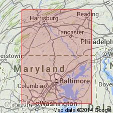
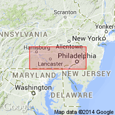
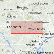
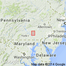
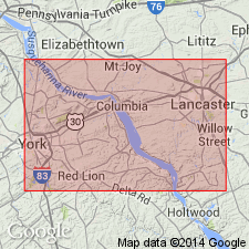
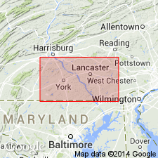
The Conestoga limestone extends from northeast of Philadelphia along Chester and Quarryville valleys to Lancaster, thence across Lancaster, York, and Hanover valleys to MD state line. Unconformably overlies formations from the Harpers schist to the Beekmantown limestone.
Source: GNU records (USGS DDS-6; Reston GNULEX).
- Usage in publication:
-
- Conestoga limestone*
- Modifications:
-
- Biostratigraphic dating
- AAPG geologic province:
-
- Piedmont-Blue Ridge province
Summary:
On basis of fossils collected at Henderson, the Conestoga limestone in Chester Valley is of late Canadian age (of Ulrich) and is equivalent to the Beekmantown formation. In Norristown area, the Conestoga overlies the Elbrook limestone and Ledger dolomite, and southwestward, near Coatesville, overlaps older limestones down to Antietam quartzite and Harpers phyllite. Chester Valley lies south of Mine Ridge anticline, which extends from New Providence eastward to Valley Forge. The Conestoga of type locality, in the Lancaster, York, and Hanover Valleys, lies north of Mine Ridge axis, and its southwestern end is in strike with Frederick Valley, although separated from it by an area of Triassic rocks. Without fossil evidence, it cannot be decided whether the Conestoga or area north of Mine Ridge is equivalent to the Beekmantown, as that of Chester Valley, or whether it is in part older, and of Late Cambrian or earliest Ordovician age, like the limestone of the Frederick Valley. The Conestoga is not known to be faunal equivalent of the Frederick limestone and cannot at present be correlated with it.
Source: GNU records (USGS DDS-6; Reston GNULEX).
- Usage in publication:
-
- Conestoga limestone
- Modifications:
-
- Age modified
- AAPG geologic province:
-
- Piedmont-Blue Ridge province
Summary:
Short discussion of Jonas and Stose (1936). This author believes Conestoga limestone is of Ordovician age, younger than the Beekmantown formation and older than the Martinsburg formation, and is correlated with the Jacksonburg formation of the Lehigh Valley.
Source: GNU records (USGS DDS-6; Reston GNULEX).
- Usage in publication:
-
- Conestoga Limestone*
- Modifications:
-
- Age modified
- AAPG geologic province:
-
- Piedmont-Blue Ridge province
Summary:
The Conestoga Limestone in southeastern PA is considered of Early Ordovician age. Consists of medium-gray, finely to coarsely crystalline limestone. Much of the limestone is graphitic and micaceous and is schistose in appearance. Base of formation usually contains pebble and boulder conglomerates and coarsely crystalline silty and sandy limestone. Unconformably overlies the Ledger, Kinzers, and Vintage Formations.
Source: GNU records (USGS DDS-6; Reston GNULEX).
- Usage in publication:
-
- Conestoga Limestone*
- Modifications:
-
- Age modified
- AAPG geologic province:
-
- Piedmont-Blue Ridge province
Summary:
The age of the Conestoga Limestone is changed from Early Ordovician to Middle(?) Cambrian to Early Ordovician(?).
Source: GNU records (USGS DDS-6; Reston GNULEX).
- Usage in publication:
-
- Conestoga Formation
- Modifications:
-
- Overview
- AAPG geologic province:
-
- Piedmont-Blue Ridge province
Summary:
The Conestoga Formation consists of light-gray, thin-bedded, impure, contorted limestone with shale partings; conglomeratic at base. In Chester Valley, includes alternating dolomite and limestone in lower part, phyllite in middle, and micaceous limestone in upper part. Unit is of Cambrian and Ordovician age.
Source: GNU records (USGS DDS-6; Reston GNULEX).
- Usage in publication:
-
- Conestoga Limestone
- Modifications:
-
- Revised
- Overview
- AAPG geologic province:
-
- Appalachian basin
Summary:
Most spectacular lithofacies of the Conestoga is the polymictic megaconglomerate or megabreccia. These debris flow deposits include clasts ranging upward to 30 ft or more. Other lithologies include lithoclastic lime grainstone, peloidal or oolitic lime grainstone, limestone-shale rhythmite, black graphitic limestone, and black phyllite. The West York Member occurs at the base of the formation in the northwestern part of the valley. This member is replace to the southeast by the Kreutz Creek Member. The Wrightsville Member overlies both the West York and the Kreutz Creek. [Members were named by G. Gohn (1976) in a Ph.D dissertation and are considered informal by the GNU.]
Source: GNU records (USGS DDS-6; Reston GNULEX).
For more information, please contact Nancy Stamm, Geologic Names Committee Secretary.
Asterisk (*) indicates published by U.S. Geological Survey authors.
"No current usage" (†) implies that a name has been abandoned or has fallen into disuse. Former usage and, if known, replacement name given in parentheses ( ).
Slash (/) indicates name conflicts with nomenclatural guidelines (CSN, 1933; ACSN, 1961, 1970; NACSN, 1983, 2005, 2021). May be explained within brackets ([ ]).